
Search
Remove Ads
Advertisement
Search Results

Image
Map of the Crusader States, 1229-1240 CE
A map indicating the territories controlled by the Crusader States or Latin East from 1229 CE to 1240 CE after the Sixth Crusade (1227-1229 CE)

Image
Kushan Empire & Neighboring States
This map shows the extent of the Kushan empire along with the various states and kingdoms that surrounded it at roughly the same time period. c. 100 - 240 CE.

Image
Map of Ancient Georgian States (600-150 BCE)
Map showing the ancient states in the western Caucasus (modern-day Georgia) from c. 600 BCE to 150 BCE.

Image
Map of Korean States in 108 BCE
A map of the Korean states in 108 BCE.
Image
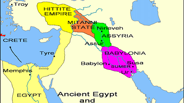
States of the Fertile Crescent, c. 1450 BCE
A map illustrating the various political states within the Fertile Crescent c. 1450 BCE.

Definition
Amistad Seizure - The Court Case that Captivated the World
The Amistad Seizure (also known as the Amistad Incident, the Amistad Rebellion, the Amistad Mutiny, and Amistad Revolt) was a conflict aboard the Spanish schooner La Amistad in July 1839, off the coast of Cuba, during which free Blacks, who...

Image
Crusader States 1200 CE
This map shows the crusader states c. 1200 CE.

Image
Baltic States 1100-1400 CE
This map illustrates the Baltic states in the period 1100-1400 CE.
Image
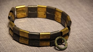
Warring States Period Dog Collar
Warring States Period dog collar.
Zhongshan State Gallery, Hebei Museum, Shijiazhuang, China.
Image
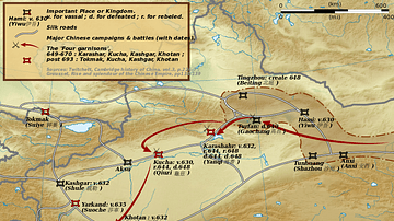
Taizong's Campaigns Against the Xiyu States
A map illustrating the campaigns of Tang Dynasty emperor Taizong (r. 626-649 CE) against the Xiyu states in China.