
Search
Remove Ads
Advertisement
Search Results

Video
History of the English East India Company
Did you know the English East India Company’s tea trade was fueled by the opium trade? The English East India Company (EIC) – also known as the British East India Company – was an immensely successful trading company founded in 1600...
Image
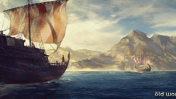
Seafaring in the Middle Ages
Artist's impression of medieval seafaring. The left ship in the foreground depicts a cog, which is a medieval ship that was widely used by traders of the Hanseatic League. The ship in the background depicts a Scandinavian or Viking ship.

Image
Middle Byzantine Medallion with the Virgin
Byzantine medallion with the Virgin from an icon frame, gold, silver, and enamel worked in cloisonné, c. 1100. The medallion was originally one of twelve that once surrounded an icon of the archangel Gabriel. Metropolitan Museum of Art...
Image
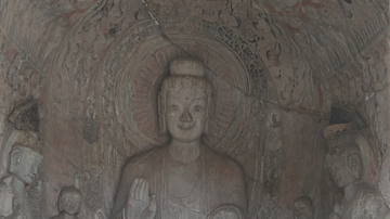
Longmen Grottoes - Middle Binyang Cave
Early Northern Wei style grotto at Longmen Grottoes, Henan Province, China. c. 500 CE

Image
Ancient Near East c.1500-1300 BCE - The Old Hittite Collapse and the Rise of Kassites, Mitanni, and the New Kingdom of Egypt
This map illustrates the geopolitical landscape of the ancient Near East following the destructive campaigns of the Old Hittite Empire (circa 1650–1500 BCE), which triggered widespread upheaval and realigned regional power structures. In...

Image
The Ancient Near East, c. 1300 BCE - On the Eve of Collapse: Power and Politics in the Late Bronze Age
This map illustrates the shifting political landscape of the Ancient Near East in the 13th century BCE, a period marked by the rise of imperial powers and the decline of older kingdoms. The expansion of the Hittite and Assyrian empires redrew...

Image
Dutch East India Company Trading Regions
Map of East India, taken from the Atlas van der Hagen, Koninklijke Bibliotheek, The Hague Part 4. This map of South East Asia was published by Nicolaas Visscher II (1649-1702). The map shows the entire trading region of the Dutch East India...

Image
Map of the East India Company Trade, c.1800
The English East India Company (EIC) was established by Royal Charter on 31 December 1600 under Queen Elizabeth I (reign 1558–1603), granting it a monopoly on English trade east of the Cape of Good Hope. Initially conceived as a commercial...

Image
Original Flag of the English East India Company
The original flag of the English East India Company (EIC), founded in 1600 by royal charter. The company later changed its name to the British East India Company and so the cross of St. George in the top right corner was replaced by a Union...

Image
Britannia Receiving the Riches of the East
A 1778 allegorical painting commissioned by the East India Company showing the riches of the East being presented to Britannia. Painted by Spyridon Romas. The goods shown include tea, porcelain, and jewels. (British Library, London)