
Search
Remove Ads
Advertisement
Search Results
Image
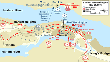
Map of the Battle of Fort Washington, 16 November 1776
A map detailing the troop movements at the Battle of Fort Washington (16 November 1776).
Made by Wikipedia user Oneam, 13 July 2013.

Image
Bombardment of Fort Sumter by Currier & Ives
Bombardment of Fort Sumter, Charleston Harbor: 12th & 13th of April, 1861, the attack that started the American Civil War, colored lithograph by Currier & Ives, 1861.
Library of Congress, Washington, D.C.
Image
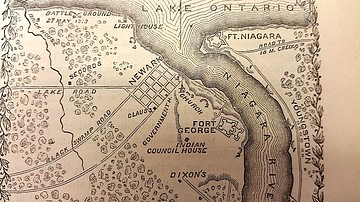
Map of Fort George, c. 1812
Map of Fort George and surrounding areas during the War of 1812, from The Pictorial Field Book of the War of 1812 by Benson Lossing.

Image
Roman Fort, Lunt
A reconstruction of the gate of the Roman fort at Lunt (Coventry, UK)

Image
Aalen Roman Limes Fort, Germany
The Aalen Roman Fort was a Roman military camp on the Upper Germanic-Rhaetian Limes, a World Heritage Site in Germany. It was built in the 2nd century CE and was the largest cavalry garrison north of the Alps. The garrison was home to 1,000...

Image
Ethan Allen Demands the Surrender of Fort Ticonderoga
Ethan Allen demands the surrender of Fort Ticonderoga 'in the name of the Great Jehovah and the Continental Congress' on 10 May 1775. Print, c. 1869. New York Public Library, Emmet Collection of Manuscripts Etc. Relating to American History...

Image
Capture of Fort Ticonderoga
A print depicting Ethan Allen demanding the surrender of Fort Ticonderoga, 10 May 1775. By John Steeple Davis, 1875. Originally published in The Aldine: the Art Journal of America. (New York: The Aldine Co., 1868-1879) New York Public Library...
Image
Vetoniana Roman Limes Fort, Germany
Vetoniana is a Roman cohort camp near Pfünz in Bavaria, Germany. Probably constructed around 90 CE as a wooden and earth structure and later rebuilt in stone, Fort Vetoniana was garrisoned by a unit of 500 men, including some cavalry. Of...

Image
Vindolanda Roman Fort
Vindolanda was one of the Stanegate forts that pre-dated Hadrian's Wall. Constructed in about 85 CE and occupied until the end of Roman Britain, Vindolanda was the longest-occupied fort on the line of the Wall.
Image
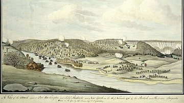
Battle of Fort Washington
Attack on the American garrison of Fort Washington by the British and Hessians, 16 November 1776. Watercolor by Thomas Davies, 1776.
New York Public Library.