
Search
Remove Ads
Advertisement
Search Results

Image
East India Company Trooper & Sepoy
An 1839 illustration showing a trooper and sepoy (Indian recruit) of the East India Company army. 27th Regiment of Madras Native Infantry. (British Library, London)

Image
Dutch East India Company Logo
Blue and white Dutch East India Company (Vereenigde Oostindische Compagnie or VOC) logo from 1650-1674. Made in Japan to order by the company's directors in Batavia (Jakarta). Date between 1615 and 1674.

Image
Maryland, Dutch East Indies
A Swiss plantation in the Dutch East Indies bought in 1881 by Karl Krüsi (1855–1925) and named after Mary, his wife. In 1893, he sold it for a fortune and built the Villa Sumatra Zurich’s Sumatrastrasse. Manager House in Deli, Karl Krüsi...

Image
Pieter de Carpentier - Governor General of the Dutch East Indies
Pieter de Carpentier (1586-1659) - Governor General of the Dutch East Indies.

Video
A New History of the Ancient Near East with Amanda Podany
Weavers, Scribes, and Kings: A New History of the Ancient Near East by Amanda H. Podany is a unique history of the ancient Near East that compellingly presents the life stories of kings, priestesses, merchants, bricklayers, and others. Rather...
![Chogha Zanbil Ziggurat [East Side], Iran](https://www.worldhistory.org/img/c/p/360x202/10670.jpg?v=1779796397)
Image
Chogha Zanbil Ziggurat [East Side], Iran
View of the east side of the ziggurat of Chogha Zanbil with the southeastern stairway which provided access to the first terrace. Chogha Zanbil is a magnificent, 3300-year-old ancient Elamite complex located 30 kilometres south-east of the...
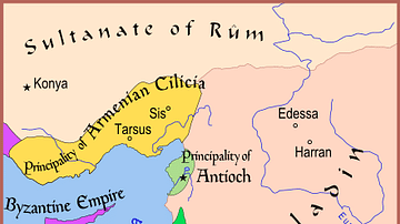
Image
Map of The Latin East, 1190 CE
A map of the Middle East showing the Crusader-held Latin East states at the time of the Third Crusade (1189-1192 CE).

Image
Jan Pieterszoon Coen, Governor General of the Dutch East Indies
Jan Pieterszoon Coen (1587-1629), an officer of the Dutch East India Company and twice the company's Governor-General in the Dutch East Indies, oil on wood portrait after Jacob Waben, 1629.
Westfries Museum, Hoorn, The Netherlands.

Image
Map of Mesopotamia and the Ancient Near East, c. 1300 BCE
Map of Mesopotamia and the Ancient Near East c. 1300 BCE, showing the period of Great Powers, with the six large kingdoms and empires (the Hittites, the Mycenaean Civilization, Assyria, Babylonia, Elam and the New Kingdom of Egypt) co-existing...

Image
Map of the Trade Links between Rome & the East
The network popularly known as the Silk Road refers not to a single route but to a shifting constellation of overland and maritime pathways that connected East and West across more than a millennium. Long before the term was coined in the...