
Search
Remove Ads
Advertisement
Search Results

Image
Map of the Greek City-states c. 500 BCE
This map illustrates the city-states of Classical Greece around 500 BCE, highlighting the rise of the polis system and the growing reach of Hellenic influence along the Mediterranean and Black Sea coasts. The period saw Athens and Sparta...

Definition
Peace of Westphalia
The Peace of Westphalia, the name given to the multiple treaties, marked the conclusion of the Thirty Years' War. Signed on 24 October 1648, it aimed to secure political autonomy for the multitude of small states that made up the Holy Roman...
Image
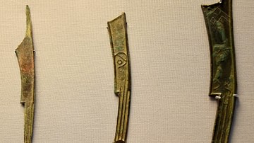
Knife Money from Ancient China
Knife money of the Warring States period retained some features of the real tools, including the ring and the strengethening ridges on the handle. The States in the north and north-east issued knife money. 1. Zhao State, circa 500 BCE...
Image
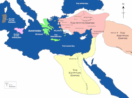
Map of the Hittite Empire and Surrounding States
A map of the Hittite Empire and surrounding states, including the Assyrian Empire, the Egyptian Empire, and Ahhiyawa.
This map is an extract from the book Empires of Bronze by Gordon Doherty, republished with permission.

Image
Map of the Crusader States, 1229-1240 CE
A map indicating the territories controlled by the Crusader States or Latin East from 1229 CE to 1240 CE after the Sixth Crusade (1227-1229 CE)
Image
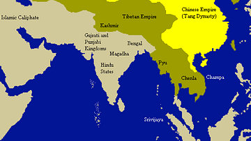
Tang Empire & Neighbouring States
A map indicating the extent of the Tang empire (618-907 CE) and its neighbouring states and tribes people.

Image
Scene at the Signing of the Constitution of the United States
A scene at the signing of the US Constitution, oil on canvas painting by Howard Chandler Christy, 1940.
United States Capitol, Washington, D.C.

Image
Map of Ancient Georgian States (600-150 BCE)
Map showing the ancient states in the western Caucasus (modern-day Georgia) from c. 600 BCE to 150 BCE.

Image
Map of Korean States in 108 BCE
A map of the Korean states in 108 BCE.

Image
Kushan Empire & Neighboring States
This map shows the extent of the Kushan empire along with the various states and kingdoms that surrounded it at roughly the same time period. c. 100 - 240 CE.