
Search
Remove Ads
Advertisement
Search Results
Image
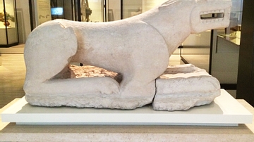
Lioness of Baena
The "Lioness of Baena" was made of limestone in the 5th century BCE by ancient Iberian people. It was found at Minguillar Hill (Baena, Córdoba), Spain. In a menacing pose with open jaws, this lioness may have been a protective element on...
Image
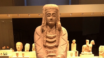
Great Lady Offerant
This almost life-sized female sculpture is carved in the round in an offerant pose. It dates from the 3rd century BCE, and it is ancient Iberian in origin. It was found at the Shrine of Cerro de los Santos (Montealegre del Castillo, Albacete...

Definition
Roman Republic
In the late 6th century BCE, the small city-state of Rome overthrew the shackles of monarchy and created a republican government that, in theory if not always in practice, represented the wishes of its citizens. From this basis the city would...

Collection
17 Campaigns & Battles of Napoleon
Napoleon Bonaparte (1769-1821), Emperor of the French, was one of the most successful military commanders of the modern era. From relatively humble beginnings, he rose to prominence during the tumultuous wars of the French Revolution, ultimately...

Definition
Rashidun Caliphate
The first four caliphs of the Islamic empire – Abu Bakr, Umar, Uthman, and Ali are referred to as Rashidun (rightly guided) Caliphs (632-661 CE) by mainstream Sunni Muslims. Their tenure started with the death of Prophet Muhammad in 632 CE...

Article
Origins of World Agriculture
Agriculture arose independently at several locations across the world, beginning about 12,000 years ago. The first crops and livestock were domesticated in six rather diffuse areas including the Near East, China, Southeast Asia, and Africa...

Definition
Roman Gaul
Roman Gaul is an umbrella term for several Roman provinces in western Europe: Cisalpine Gaul or Gallia Cisalpina, comprised a territory situated in the northernmost part of the Italian peninsula ranging from the Apennines in the west northward...

Definition
Queen Seondeok
Queen Seondeok (Sondok) ruled the ancient kingdom of Silla from 632 to 647 CE and was the first female sovereign in ancient Korea. Silla was on the verge of dominating the whole of the Korean peninsula and Seondeok helped progress her kingdom...
Definition
Baekje
Baekje (Paekche) was one of the Three Kingdoms which ruled over ancient Korea from the 1st century BCE to the 7th century CE. Controlling territory in the south-western part of the peninsula the kingdom was in constant rivalry with the other...

Definition
Taejo of Goryeo
Taejo (r. 918-943 CE), previously known as Wang Geon or Wang Kon, was the founder and first king of the Goryeo (Koryo) kingdom which unified and ruled ancient Korea from 918 CE to 1392 CE. Wang Geon was given the posthumous title of Taejo...