
Browse Content

Image
Regions of Ancient Greece
A map of the primary regions of ancient Greece's mainland along...

Image
Siege of Dunkirk and Battle of Hondschoote, August-September 1793
Map depicting the Siege of Dunkirk and Battle of Hondschoote, between...

Image
Map of the Parthian Empire in the 2nd Century
This map illustrates the Parthian Kingdom (c. 247 BCE–224 CE...

Image
Map of Roman North Africa (146 BCE - 395 CE)
This map illustrates the scope and administrative organization...

Image
Map of the New Kingdom of Egypt c. 1250 BCE
The New Kingdom of Egypt (c. 1570–1069 BCE) marks the apex of ancient...
Image
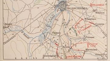
Map of Famars and Raismes
Map showing the Battle of Famars, also showing the woodlands around...