
Browse Content

Image
Map of the Two North American Voyages of Henry Hudson
Map of the two North American voyages of Henry Hudson (c. 1570-1611...

Image
Map of the Roman Rule in Britain c. 43 - 410 CE - Four Centuries of Empire at the Edge of the World
Roman rule in Britain developed between 43 and 410 CE, reshaping...

Image
Map of the Year of the Four Emperors, 69 CE
The Year of the Four Emperors (69 CE) was a moment of deep instability...
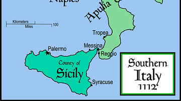
Image
Southern Italy & Sicily, 1112
Political map of southern Italy c. 1112, showing the extent of...

Image
Prominent Cities of Europe from Antiquity to the Present
A map of Europe displaying important cities that shaped its history...

Image
Napoleon: Map of the Battle of Rivoli, 14-15 Jan 1797
The Battle of Rivoli (14–15 January 1797) was a decisive confrontation...