
Browse Content

Image
Magnetic Sea Chart by Halley
A detail of a chart showing lines of magnetic compass variation...

Image
Battle of Leipzig, 16 October 1813
Actions of the first day of the Battle of Leipzig, 16 October 1813...

Image
Battle of Leipzig, 18 October 1813
Actions on the second day of the Battle of Leipzig, 18 October...

Image
Map of the Route of The Spanish Armada, Jul-Sep 1588
A map illustrating the route and failing fortunes of the Spanish...
Image
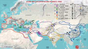
Second-Wave Civilization Natural Resources and Trade
A map illustrating the rise and spread of the Second Wave Civilizations...

Image
Ivan IV, the Terrible and the Tsardom of Russia, c. 1598
A map illustrating the rise and expansion of the Tsardom of Russia...