
Browse Content

Image
Map of the Battle of Britain, 1940
The Battle of Britain (July - October 1940) was a pivotal air campaign...

Image
Europe on the Eve of WWII, 1939
A map illustrating the growing instability in Europe in the lead-up...

Image
World War II in Europe, November 1942
A map depicting the strategic situation in Europe and the Mediterranean...

Image
Map of Roman Rule in Asia Minor, c. 200 CE
This map illustrates the geopolitical landscape of Asia Minor during...

Image
Troop Movements at the First Battle of Saratoga, 19 September 1777
Troop movements before the First Battle of Saratoga (or the Battle...
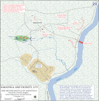
Image
Troop Movements at the Second Battle of Saratoga, 7 October 1777
Troop movements at the Second Battle of Saratoga (or Battle of...