
Browse Content
Image
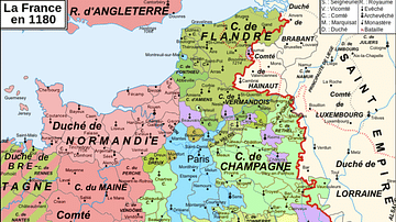
Map of 12th-Century France
A map showing the various counties and duchies of France at the...

Image
Poland-Lithuania at its Greatest Extent, 1619
A map showing the Polish-Lithuanian Republic at its greatest territorial...

Image
Map of the Four Khanates of the Mongol Empire, c. 1300
This map illustrates the four major khanates that emerged from...

Image
Map of the Russian Revolution of 1905
This map illustrates the Russian Revolution of 1905, a wave of...

Image
Map of the Russian Empire on the Eve of World War I, 1914 - A Eurasian Giant at the Brink
The Russian Empire on the eve of World War I (1914) represented...

Image
New Orleans Battle Map
A depiction of the British assault during the Battle of New Orleans...