---
title: Map of the Norman Conquest of England, 1066–1086: From Hastings to Domesday – The Making of Norman England
author: Simeon Netchev
source: https://www.worldhistory.org/image/9862/map-of-the-norman-conquest-of-england-1066-1086/
format: machine-readable-alternate
license: Creative Commons Attribution-NonCommercial-NoDerivs (https://creativecommons.org/licenses/by-nc/4.0)
updated: 2026-09-09
---
# Map of the Norman Conquest of England, 1066–1086: From Hastings to Domesday – The Making of Norman England
_Authored by [Simeon Netchev](https://www.worldhistory.org/user/simeonnetchev/)_
## Image File
[](https://www.worldhistory.org/uploads/images/9862.png)
## Image Caption
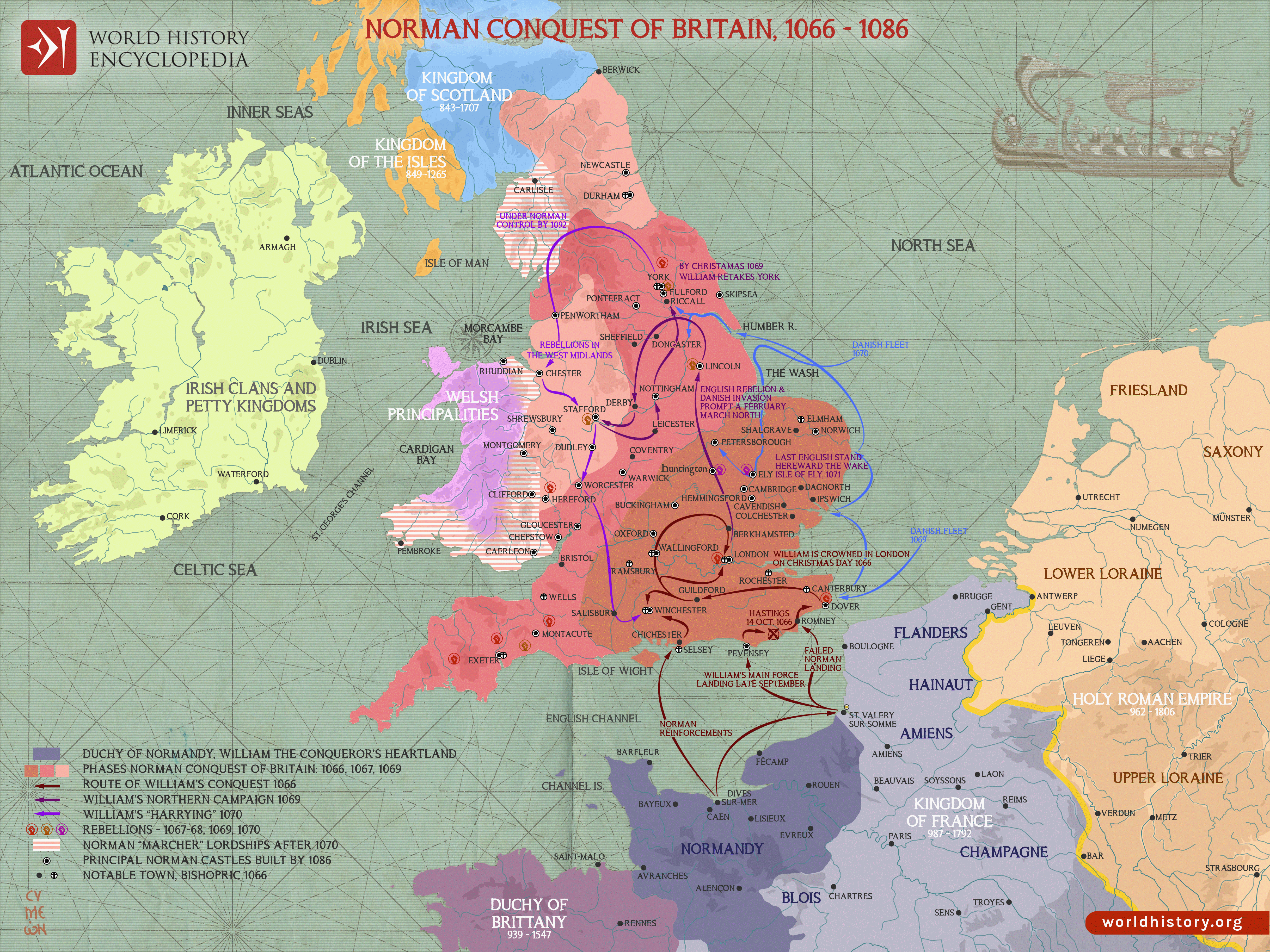
The [Norman Conquest of England](https://www.worldhistory.org/Norman_Conquest_of_England/) began in 1066 after the [death](https://www.worldhistory.org/disambiguation/Death/) of [Edward the Confessor](https://www.worldhistory.org/Edward_the_Confessor/) (reign 1042–1066) without a direct heir, creating a disputed royal succession. [Harold Godwinson](https://www.worldhistory.org/Harold_Godwinson/) was chosen and crowned Harold II (reign January–October 1066), but his claim was challenged by Harald Hardrada of Norway and William, Duke of Normandy. After defeating Hardrada and Harold’s brother Tostig at the [Battle of Stamford Bridge](https://www.worldhistory.org/article/1306/battle-of-stamford-bridge/) on 25 September, Harold marched south to confront William, whose army had landed at Pevensey on 28 September. At the [Battle of Hastings](https://www.worldhistory.org/Battle_of_Hastings/) on 14 October 1066, Harold was defeated and killed. William was crowned William I of [England](https://www.worldhistory.org/disambiguation/england/) (reign 1066–1087) at Westminster on Christmas Day, although winning the crown proved only the beginning of establishing control over the kingdom.
Between 1067 and 1071, rebellions in western, northern and eastern England, together with Danish intervention, forced William to combine military campaigns with negotiated submission, castle-building, land confiscation and the redistribution of estates to Norman and other continental followers. The Harrying of the North (1069–1070) and the defeat of the remaining major resistance at Ely in 1071 marked crucial stages in the consolidation of Norman power. The [conquest](https://www.worldhistory.org/warfare/) replaced most of the Anglo-[Saxon](https://www.worldhistory.org/Saxons/) secular elite and much of the higher clergy, transformed patterns of aristocratic landholding, expanded castle construction and created a new cross-Channel Anglo-Norman ruling class. Yet Norman government also built upon England’s already sophisticated Anglo-Saxon institutions rather than replacing them wholesale. By the Domesday Survey of 1086, the scale of the transformation in landholding and political authority was unmistakable, making the conquest a major case study in causation, state-building, resistance, continuity and change, and cultural interaction.
#### Editorial Review
This human-authored image has been reviewed by our editorial team before publication to ensure accuracy, reliability and adherence to academic standards in accordance with our [editorial policy](https://www.worldhistory.org/static/editorial-policy/).
## About the Author
Simeon is a freelance visual designer and history educator, passionate about the human stories that shape the past.
- [Linkedin Profile](https://www.linkedin.com/in/simeon-netchev/)
## Cite This Work
### APA
Netchev, S. (2026, September 09). Map of the Norman Conquest of England, 1066–1086: From Hastings to Domesday – The Making of Norman England. *World History Encyclopedia*.
### Chicago
Netchev, Simeon. "Map of the Norman Conquest of England, 1066–1086: From Hastings to Domesday – The Making of Norman England." *World History Encyclopedia*, September 09, 2026. .
### MLA
Netchev, Simeon. "Map of the Norman Conquest of England, 1066–1086: From Hastings to Domesday – The Making of Norman England." *World History Encyclopedia*, 09 Sep 2026, .
## License & Copyright
Submitted by [Simeon Netchev](https://www.worldhistory.org/user/simeonnetchev/ "User Page: Simeon Netchev"), published on 09 September 2026. The copyright holder has published this content under the following license: [Creative Commons Attribution-NonCommercial-NoDerivs](https://creativecommons.org/licenses/by-nc/4.0deed.en). This licence only allows others to download this content and share it with others as long as the author is credited, but they can't change the content in any way or use it commercially. When republishing on the web a hyperlink back to the original content source URL must be included. Please note that content linked from this page may have different licensing terms.