---
title: Map of the Greenland-Vinland Voyage
author: Finn Bjørklid
source: https://www.worldhistory.org/image/9190/map-of-the-greenland-vinland-voyage/
format: machine-readable-alternate
license: Creative Commons Attribution-ShareAlike (https://creativecommons.org/licenses/by-sa/4.0)
updated: 1970-01-01
---
# Map of the Greenland-Vinland Voyage
_Authored by Finn Bjørklid_
## Image File
[](https://www.worldhistory.org/uploads/images/9190.jpg)
## Image Caption
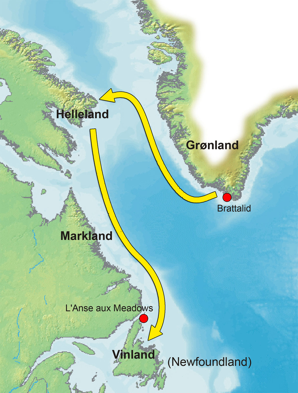
Map showing the reconstructed route Norse [Vikings](https://www.worldhistory.org/Vikings/) sailed in the [Vinland](https://www.worldhistory.org/Vinland/) sagas on their way to Vinland (Newfoundland, Canada), where they founded a settlement at the site of L'Anse aux Meadows. The sagas describe the Vikings first coming across a stone-slab land they name Helluland, then a wooded area they name Markland, and finally a lush, green land they call Vinland ('Wine Land'). To explain the areas on the map: - Brattahlid in Greenland is the estate of Erik the Red (whose son [Leif Erikson](https://www.worldhistory.org/Leif_Erikson/) sailed to Vinland arguably via a similar route to the one depicted here) in Norse Greenland's Eastern Settlement. - Helleland refers to the Helluland mentioned in the Vinland sagas and probably corresponds with northern Labrador and/or Baffin Island. - The Markland mentioned in the sagas is mirrored in the central forest belt of Labrador - L'Anse aux Meadows on the northern tip of Newfoundland is the [saga](https://www.worldhistory.org/Saga/)-site of Leifsbúðir/Straumfjǫrðr. - Vinland: It is generally thought that the Vinland from the sagas encompassed the whole area from the Strait of Belle Isle in Newfoundland to the Gulf of St Lawrence and its southern shores, perhaps stretching to Prince Edward Island and New Brunswick. The journey from Greenland to the settlement in Vinland is more than 3000 km long and would likely have taken the Vikings a minimum of two weeks (and possibly even six weeks or longer) to complete, one-way.
## Cite This Work
### APA
Bjørklid, F. (2018, September 07). Map of the Greenland-Vinland Voyage. *World History Encyclopedia*.
### Chicago
Bjørklid, Finn. "Map of the Greenland-Vinland Voyage." *World History Encyclopedia*, September 07, 2018. .
### MLA
Bjørklid, Finn. "Map of the Greenland-Vinland Voyage." *World History Encyclopedia*, 07 Sep 2018, .
## License & Copyright
[Original image](https://commons.wikimedia.org/wiki/File:Vinland-travel.jpg) by [**Finn Bjørklid**](https://commons.wikimedia.org/wiki/File:Vinland-travel.jpg). Submitted by [Emma Groeneveld](https://www.worldhistory.org/user/emmagroeneveld1/ "User Page: Emma Groeneveld"), published on 07 September 2018. The copyright holder has published this content under the following license: [Creative Commons Attribution-ShareAlike](https://creativecommons.org/licenses/by-sa/4.0deed.en). This license lets others remix, tweak, and build upon a work even for commercial reasons, as long as they credit the author and license their new creations under the identical terms. When republishing on the web a hyperlink back to the original content source URL must be included. Please note that content linked from this page may have different licensing terms.