---
title: Map of Ireland c. 950 CE
author: Threewolves
source: https://www.worldhistory.org/image/7748/map-of-ireland-c-950-ce/
format: machine-readable-alternate
updated: 1970-01-01
---
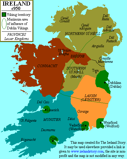
# Map of Ireland c. 950 CE
_Authored by Threewolves_
## Image File
[](https://www.worldhistory.org/uploads/images/7748.gif)
## Image Caption
Map of [Ireland](https://www.worldhistory.org/disambiguation/Ireland/) around 950 CE, showing both the local Irish kingdoms and the [Viking](https://www.worldhistory.org/Vikings/) territories. Map credited to www.irelandhistory.com
## Cite This Work
### APA
Threewolves. (2017, December 08). Map of Ireland c. 950 CE. *World History Encyclopedia*.
### Chicago
Threewolves. "Map of Ireland c. 950 CE." *World History Encyclopedia*, December 08, 2017. .
### MLA
Threewolves. "Map of Ireland c. 950 CE." *World History Encyclopedia*, 08 Dec 2017, .
## License & Copyright
[Original image](https://commons.wikimedia.org/wiki/File:Map_of_Ireland_and_Cenel_nEogain.gif) by [**Threewolves**](https://commons.wikimedia.org/wiki/File:Map_of_Ireland_and_Cenel_nEogain.gif). Submitted by [Emma Groeneveld](https://www.worldhistory.org/user/emmagroeneveld1/ "User Page: Emma Groeneveld"), published on 08 December 2017. The copyright holder has published this content under the following license: [Public Domain](http://en.wikipedia.org/wiki/Public_domain). This item is in the public domain, and can be used, copied, and modified without any restrictions. Please note that content linked from this page may have different licensing terms.