---
title: Map of the British Isles in AD 43
author: P L Kessler
source: https://www.worldhistory.org/image/742/map-of-the-british-isles-in-ad-43/
format: machine-readable-alternate
updated: 1970-01-01
---
# Map of the British Isles in AD 43
_Authored by P L Kessler_
## Image File
[](https://www.worldhistory.org/uploads/images/742.jpg)
## Image Caption
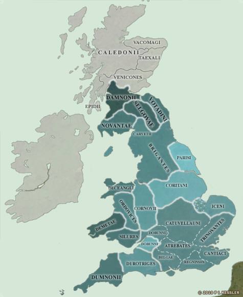
On the eve of the [Roman](https://www.worldhistory.org/disambiguation/Roman/) [Conquest](https://www.worldhistory.org/warfare/), the south-east was dominated completely by the Catuvellauni. They, if any, could claim the legendary High Kingship of [Britain](https://www.worldhistory.org/disambiguation/Britain/). As well as having conquered the Cantiaci, the Trinovantes, and the Atrebates and their subsidiary branch, the Belgae (the Regninses may not have borne a separate identity until after the Conquest), the Dobunni tribe also seem to have developed a north-south divide thanks to their powerful neighbours. The northern half was being heavily influenced by the Catuvellauni, while the southern half was clearly trying to retain some level of independence. But for the invasion, it was an independence which was unlikely to last. One wonders how long it would have been before Britain was formed of just three kingdoms: the dominating Catuvellauni; the Welsh-based tribes, having formed an alliance of necessity in the face of the threat; and the Brigantes uniting and ruling the north. It may have taken another century but the evidence suggests that it was a possibility. However, the Romans were coming...
## Cite This Work
### APA
Kessler, P. L. (2012, July 06). Map of the British Isles in AD 43. *World History Encyclopedia*.
### Chicago
Kessler, P L. "Map of the British Isles in AD 43." *World History Encyclopedia*, July 06, 2012. .
### MLA
Kessler, P L. "Map of the British Isles in AD 43." *World History Encyclopedia*, 06 Jul 2012, .
## License & Copyright
© P L Kessler / [The History Files](http://www.historyfiles.co.uk/). Republished with the author's permission. [Original image](http://www.historyfiles.co.uk/FeaturesBritain/BritishMap55BC-AD43.htm) by [**P L Kessler**](http://www.historyfiles.co.uk/FeaturesBritain/BritishMap55BC-AD43.htm). Submitted by [Jan van der Crabben](https://www.worldhistory.org/user/jvdc/ "User Page: Jan van der Crabben"), published on 06 July 2012. The copyright holder has published this content under the following license: [Copyright](http://en.wikipedia.org/wiki/Copyright). You cannot use, copy, distribute, or modify this item without explicit permission from the author. Please note that content linked from this page may have different licensing terms.