---
title: Map of the British Isles in AD 10
author: P L Kessler
source: https://www.worldhistory.org/image/740/map-of-the-british-isles-in-ad-10/
format: machine-readable-alternate
updated: 1970-01-01
---
# Map of the British Isles in AD 10
_Authored by P L Kessler_
## Image File
[](https://www.worldhistory.org/uploads/images/740.jpg)
## Image Caption
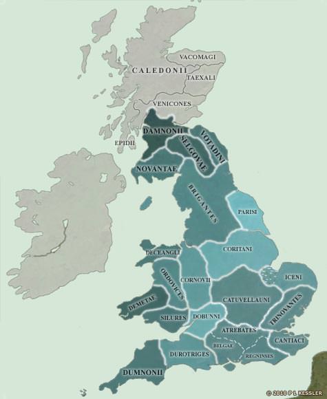
[Rome](https://www.worldhistory.org/Rome/) maintained trading and political links of a sort with the Britons, and were able to observe the slow coalescence of the south-east towards the creation of a unified kingdom. The Catuvellauni, who had already proved themselves to be national leaders in times of external threat, were starting to make their presence felt far and wide. By about AD 1 they had already placed a Catuvellauni prince, Cunobelinus, as ruler of the Trinovantes, and in circa AD 10 he became king of the Catuvellauni themselves, uniting the two kingdoms. In around AD 25 the Catuvellauni also seem to have gained control of the Cantiaci, and Cunobelinus' brother seized the throne of the Atrebates, fighting a [war](https://www.worldhistory.org/disambiguation/War/) to dislodge the ruling house from the southern half (the territory of the Belgae) and gaining it all by AD 43. The tribes further north and west had still not been identified by the Romans in the form that they are shown here, but whatever names they were using, they certainly existed, and were becoming more sophisticated as [Roman](https://www.worldhistory.org/disambiguation/Roman/) imports made their way inland from the kingdoms on the coast.
## Cite This Work
### APA
Kessler, P. L. (2012, July 06). Map of the British Isles in AD 10. *World History Encyclopedia*.
### Chicago
Kessler, P L. "Map of the British Isles in AD 10." *World History Encyclopedia*, July 06, 2012. .
### MLA
Kessler, P L. "Map of the British Isles in AD 10." *World History Encyclopedia*, 06 Jul 2012, .
## License & Copyright
© P L Kessler / [The History Files](http://www.historyfiles.co.uk/). Republished with the author's permission. [Original image](http://www.historyfiles.co.uk/FeaturesBritain/BritishMap55BC-AD43.htm) by [**P L Kessler**](http://www.historyfiles.co.uk/FeaturesBritain/BritishMap55BC-AD43.htm). Submitted by [Jan van der Crabben](https://www.worldhistory.org/user/jvdc/ "User Page: Jan van der Crabben"), published on 06 July 2012. The copyright holder has published this content under the following license: [Copyright](http://en.wikipedia.org/wiki/Copyright). You cannot use, copy, distribute, or modify this item without explicit permission from the author. Please note that content linked from this page may have different licensing terms.