---
title: Map of the British Isles in 54 BC
author: P L Kessler
source: https://www.worldhistory.org/image/739/map-of-the-british-isles-in-54-bc/
format: machine-readable-alternate
updated: 1970-01-01
---
# Map of the British Isles in 54 BC
_Authored by P L Kessler_
## Image File
[](https://www.worldhistory.org/uploads/images/739.jpg)
## Image Caption
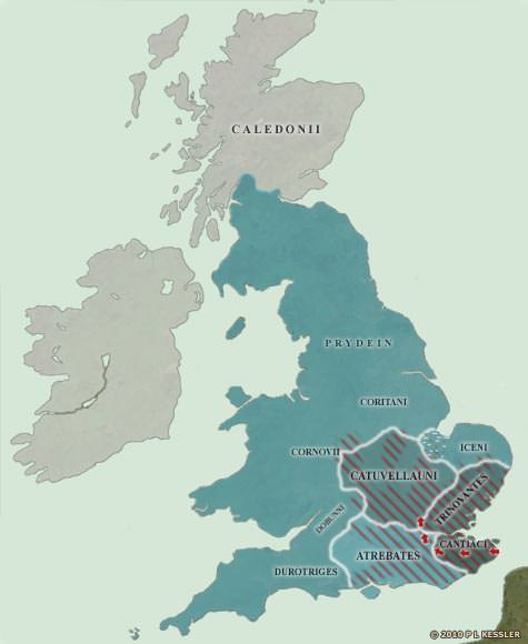
When [Julius Caesar](https://www.worldhistory.org/Julius_Caesar/) landed on the Kent coast in 55 BC, he had a basic knowledge of what to expect of the south-eastern Britons from his dealings with their close relatives on the Continent. What he wasn't prepared for was the English Channel, and some bad weather almost cost him dear. His expedition doesn't seem to have made it out of Kent's borders on this occasion. However, when he returned a year later, it was with a much larger force and a much better idea of how to deal with some of the problems. He quickly defeated the Cantiaci and advanced towards the Thames, crossing it at modern-day Brentford in Essex. He received envoys and offers of friendship from six tribes in the south, although the British tribal names that are mentioned (not shown) cannot be tied in with any later information. Then he marched on the Catuvellauni stronghold near St Albans, and his victory over them would have delivered him the entire south-east, had he stayed. Instead, he decided to winter in [Gaul](https://www.worldhistory.org/gaul/), and events there conspired to prevent him ever returning to [Britain](https://www.worldhistory.org/disambiguation/Britain/).
## Cite This Work
### APA
Kessler, P. L. (2012, July 06). Map of the British Isles in 54 BC. *World History Encyclopedia*.
### Chicago
Kessler, P L. "Map of the British Isles in 54 BC." *World History Encyclopedia*, July 06, 2012. .
### MLA
Kessler, P L. "Map of the British Isles in 54 BC." *World History Encyclopedia*, 06 Jul 2012, .
## License & Copyright
© P L Kessler / [The History Files](http://www.historyfiles.co.uk/). Republished with the author's permission. [Original image](http://www.historyfiles.co.uk/FeaturesBritain/BritishMap55BC-AD43.htm) by [**P L Kessler**](http://www.historyfiles.co.uk/FeaturesBritain/BritishMap55BC-AD43.htm). Submitted by [Jan van der Crabben](https://www.worldhistory.org/user/jvdc/ "User Page: Jan van der Crabben"), published on 06 July 2012. The copyright holder has published this content under the following license: [Copyright](http://en.wikipedia.org/wiki/Copyright). You cannot use, copy, distribute, or modify this item without explicit permission from the author. Please note that content linked from this page may have different licensing terms.