---
title: Map of Mesopotamia, 2000-1600 BCE
author: P L Kessler
source: https://www.worldhistory.org/image/588/map-of-mesopotamia-2000-1600-bce/
format: machine-readable-alternate
updated: 1970-01-01
---
# Map of Mesopotamia, 2000-1600 BCE
_Authored by P L Kessler_
## Image File
[](https://www.worldhistory.org/uploads/images/588.jpg)
## Image Caption
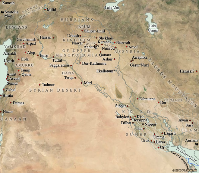
A general map of [Mesopotamia](https://www.worldhistory.org/Mesopotamia/) and its neighbouring territories which roughly covers the period from 2000-1600 BCE reveals the concentration of [city](https://www.worldhistory.org/city/) states in [Sumer](https://www.worldhistory.org/sumer/), in the south. This is where the first true city-states arose, although the [cities](https://www.worldhistory.org/city/) of northern Mesopotamia and [Syria](https://www.worldhistory.org/syria/) were roughly contemporaneous. However, the latter remained relatively minor states with a less intensive level of development until the collapse of [Sumerian](https://www.worldhistory.org/Sumerians/) [civilization](https://www.worldhistory.org/civilization/). In the ensuing power vacuum, cities such as [Ashur](https://www.worldhistory.org/ashur/) (one of the three main Assyrian cities), and Ebla and [Babylon](https://www.worldhistory.org/babylon/) (both [Amorite](https://www.worldhistory.org/amorite/) cities) quickly grew in wealth and strength. Shubat-[Enlil](https://www.worldhistory.org/Enlil/), in the Khabur river valley in northern Mesopotamia, was the rapidly developed capital of Shamshi-Adad's kingdom of Upper Mesopotamia in the 19th century BCE. Before that it had been a Halaf [Culture](https://www.worldhistory.org/disambiguation/culture/) town and the capital of a minor state called Apum.
## Bibliography
- Anonymous. *Bartholomew's World Atlas.*
- [Christopher Scarre. *Past Worlds.* Times Books, 1995.](https://www.worldhistory.org/books/0723008108/)
- Croft, John D. *Map of Sumer.*
## Cite This Work
### APA
Kessler, P. L. (2012, April 26). Map of Mesopotamia, 2000-1600 BCE. *World History Encyclopedia*.
### Chicago
Kessler, P L. "Map of Mesopotamia, 2000-1600 BCE." *World History Encyclopedia*, April 26, 2012. .
### MLA
Kessler, P L. "Map of Mesopotamia, 2000-1600 BCE." *World History Encyclopedia*, 26 Apr 2012, .
## License & Copyright
© P L Kessler / [The History Files](http://www.historyfiles.co.uk/). Republished with the author's permission. [Original image](http://www.historyfiles.co.uk/FeaturesMiddEast/MesopotamiaMap.htm) by [**P L Kessler**](http://www.historyfiles.co.uk/FeaturesMiddEast/MesopotamiaMap.htm). Submitted by [Jan van der Crabben](https://www.worldhistory.org/user/jvdc/ "User Page: Jan van der Crabben"), published on 26 April 2012. The copyright holder has published this content under the following license: [Copyright](http://en.wikipedia.org/wiki/Copyright). You cannot use, copy, distribute, or modify this item without explicit permission from the author. Please note that content linked from this page may have different licensing terms.