---
title: Babylonian Map of the World
author: Trustees of the British Museum
source: https://www.worldhistory.org/image/526/babylonian-map-of-the-world/
format: machine-readable-alternate
updated: 1970-01-01
---
# Babylonian Map of the World
_Authored by Trustees of the British Museum_
## Image File
[](https://www.worldhistory.org/uploads/images/526.jpg)
## Image Caption
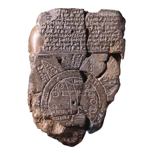
Babylonian, about 700-500 BCE
Probably from Sippar, southern Iraq
A unique ancient map of the Mesopotamian world
This tablet contains both a [cuneiform](https://www.worldhistory.org/cuneiform/) inscription and a unique map of the Mesopotamian world. [Babylon](https://www.worldhistory.org/babylon/) is shown in the centre (the rectangle in the top half of the circle), and [Assyria](https://www.worldhistory.org/assyria/), [Elam](https://www.worldhistory.org/elam/) and other places are also named. The central area is ringed by a circular waterway labelled 'Salt-Sea'. The outer rim of the sea is surrounded by what were probably originally eight regions, each indicated by a triangle, labelled 'Region' or 'Island', and marked with the distance in between. The cuneiform text describes these regions, and it seems that strange and mythical beasts as well as great heroes lived there, although the text is far from complete.
The regions are shown as triangles since that was how it was visualized that they first would look when approached by water.
The map is sometimes taken as a serious example of ancient geography, but although the places are shown in their approximately correct positions, the real purpose of the map is to explain the Babylonian view of the mythological world.
I.L. Finkel, 'A join to the Map of the World: a notable discovery', British Museum Magazine: the-5 (Winter 1995), pp. 26-27
W. Horowitz, Mesopotamian cosmic geography (Winona Lake, Eisenbrauns, 1998)
I.L. Finkel, [Gilgamesh](https://www.worldhistory.org/gilgamesh/): the hero king (London, The British Museum Press, 1998)
## Cite This Work
### APA
Museum, T. o. t. B. (2012, April 26). Babylonian Map of the World. *World History Encyclopedia*.
### Chicago
Museum, Trustees of the British. "Babylonian Map of the World." *World History Encyclopedia*, April 26, 2012. .
### MLA
Museum, Trustees of the British. "Babylonian Map of the World." *World History Encyclopedia*, 26 Apr 2012, .
## License & Copyright
© Trustees of the [British Museum](http://www.britishmuseum.org/). Republished under the British Museum [Standard Terms of Use](http://www.britishmuseum.org/about_this_site/terms_of_use.aspx) for non-profit educational purposes. [Original image](http://www.britishmuseum.org/explore/galleries/middle_east/room_55_mesopotamia.aspx) by [**Trustees of the British Museum**](http://www.britishmuseum.org/explore/galleries/middle_east/room_55_mesopotamia.aspx). Submitted by [Jan van der Crabben](https://www.worldhistory.org/user/jvdc/ "User Page: Jan van der Crabben"), published on 26 April 2012. The copyright holder has published this content under the following license: [Copyright](http://en.wikipedia.org/wiki/Copyright). You cannot use, copy, distribute, or modify this item without explicit permission from the author. Please note that content linked from this page may have different licensing terms.