---
title: Map of the Korean War, 1950–1953: Major Campaigns and Front-Line Movements
author: Simeon Netchev
source: https://www.worldhistory.org/image/22121/map-of-the-korean-war-1950-1953/
format: machine-readable-alternate
license: Creative Commons Attribution-NonCommercial-NoDerivs (https://creativecommons.org/licenses/by-nc/4.0)
updated: 2026-09-14
---
# Map of the Korean War, 1950–1953: Major Campaigns and Front-Line Movements
_Authored by [Simeon Netchev](https://www.worldhistory.org/user/simeonnetchev/)_
## Image File
[](https://www.worldhistory.org/uploads/images/22121.png)
## Image Caption
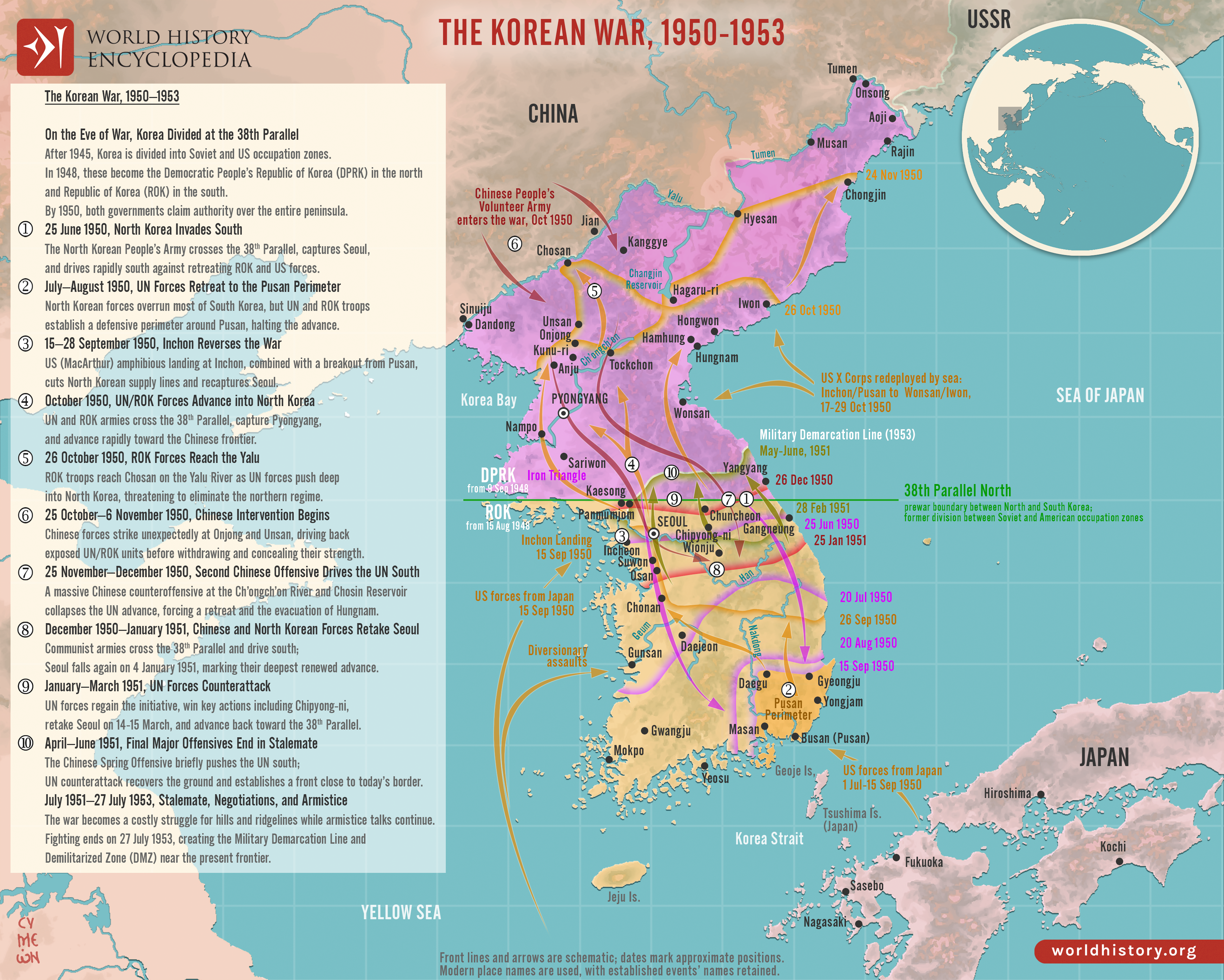
The Korean [War](https://www.worldhistory.org/disambiguation/War/) (1950–1953) began on 25 June 1950 when communist North [Korea](https://www.worldhistory.org/Korea/), the Democratic People’s Republic of Korea (DPRK), invaded South Korea, the Republic of Korea (ROK), across the 38th Parallel. United Nations forces led by the United States intervened in support of South Korea, halting the North Korean advance at the Pusan Perimeter before the Inchon Landing reversed the campaign. UN and ROK forces then advanced into North Korea toward the Yalu River, prompting large-scale Chinese intervention in October and November 1950.
The conflict became a major confrontation of the Cold War, linking Korean political division and competing claims to reunification with the wider struggle between communist and Western-aligned powers. After repeated advances and retreats, the front stabilized near the 38th Parallel in mid-1951, followed by two years of positional [warfare](https://www.worldhistory.org/warfare/) and armistice negotiations. Fighting ended on 27 July 1953 with the Korean Armistice Agreement, establishing the Military Demarcation Line and Demilitarized Zone (DMZ). No permanent peace treaty followed, leaving Korea divided between North and South.
#### Editorial Review
This human-authored image has been reviewed by our editorial team before publication to ensure accuracy, reliability and adherence to academic standards in accordance with our [editorial policy](https://www.worldhistory.org/static/editorial-policy/).
## About the Author
Simeon is a freelance visual designer and history educator, passionate about the human stories that shape the past.
- [Linkedin Profile](https://www.linkedin.com/in/simeon-netchev/)
## Cite This Work
### APA
Netchev, S. (2026, September 14). Map of the Korean War, 1950–1953: Major Campaigns and Front-Line Movements. *World History Encyclopedia*.
### Chicago
Netchev, Simeon. "Map of the Korean War, 1950–1953: Major Campaigns and Front-Line Movements." *World History Encyclopedia*, September 14, 2026. .
### MLA
Netchev, Simeon. "Map of the Korean War, 1950–1953: Major Campaigns and Front-Line Movements." *World History Encyclopedia*, 14 Sep 2026, .
## License & Copyright
Submitted by [Simeon Netchev](https://www.worldhistory.org/user/simeonnetchev/ "User Page: Simeon Netchev"), published on 14 September 2026. The copyright holder has published this content under the following license: [Creative Commons Attribution-NonCommercial-NoDerivs](https://creativecommons.org/licenses/by-nc/4.0deed.en). This licence only allows others to download this content and share it with others as long as the author is credited, but they can't change the content in any way or use it commercially. When republishing on the web a hyperlink back to the original content source URL must be included. Please note that content linked from this page may have different licensing terms.