---
title: Map of the Allied Pacific Counteroffensive, 1942–1945: WWII's Pacific War
author: Simeon Netchev
source: https://www.worldhistory.org/image/22056/map-of-the-allied-pacific-counteroffensive-1942-19/
format: machine-readable-alternate
license: Creative Commons Attribution-NonCommercial-NoDerivs (https://creativecommons.org/licenses/by-nc/4.0)
updated: 2026-08-25
---
# Map of the Allied Pacific Counteroffensive, 1942–1945: WWII's Pacific War
_Authored by [Simeon Netchev](https://www.worldhistory.org/user/simeonnetchev/)_
## Image File
[](https://www.worldhistory.org/uploads/images/22056.png)
## Image Caption
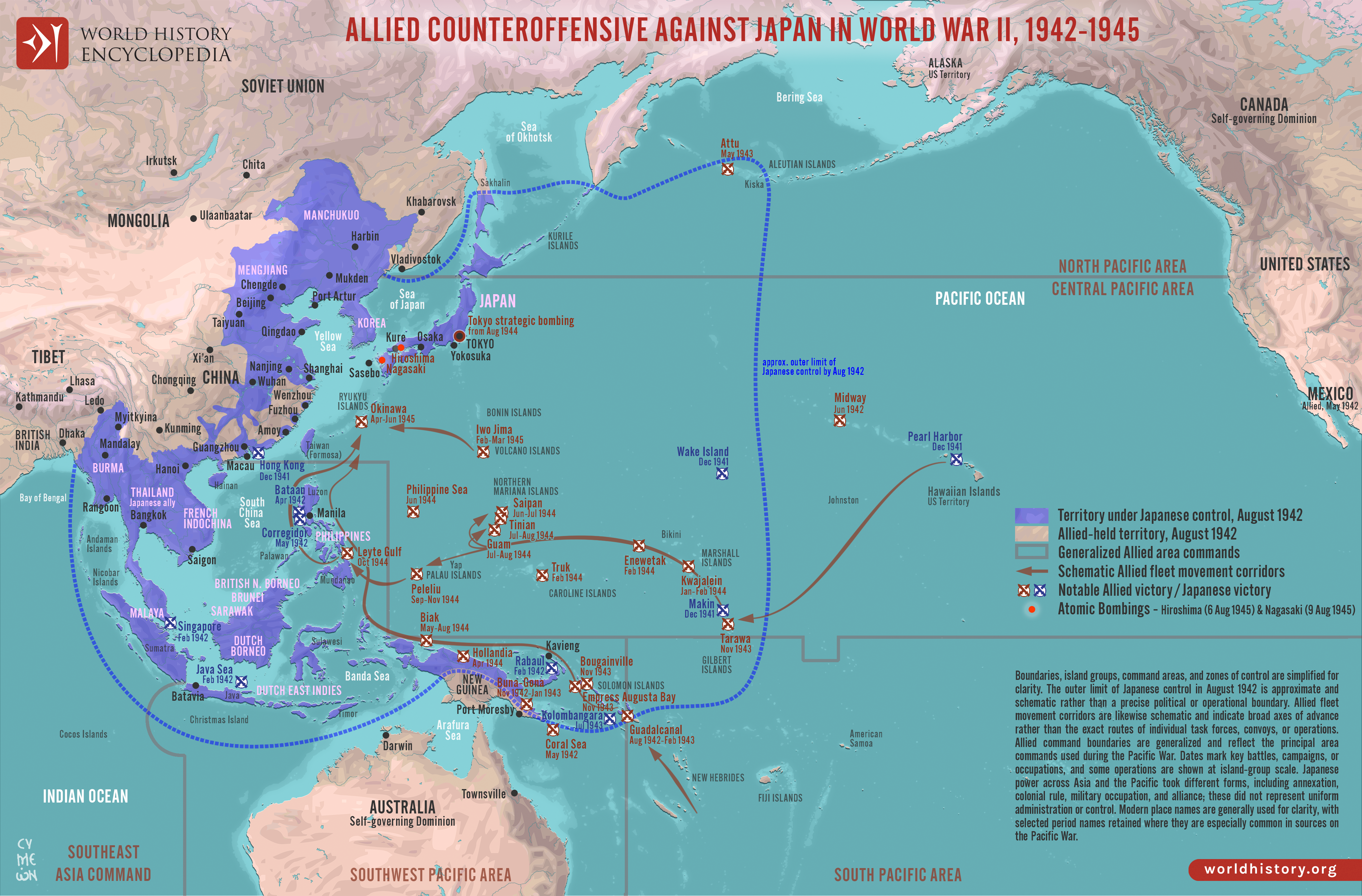
From mid-1942, the Allied [war](https://www.worldhistory.org/disambiguation/War/) against [Japan](https://www.worldhistory.org/disambiguation/Japan/) shifted from containing expansion to sustained counteroffensive. The [Battle of the Coral Sea](https://www.worldhistory.org/article/2957/battle-of-the-coral-sea/) (May 1942) checked the seaborne advance toward Port Moresby, while Midway (June 1942) severely weakened Japanese carrier strength. The [Guadalcanal campaign](https://www.worldhistory.org/Guadalcanal_Campaign/) (August 1942–February 1943) then opened the first major Allied offensive against Japan. Across New Guinea and the [Solomon](https://www.worldhistory.org/solomon/) Islands, growing Allied air and naval power, amphibious [warfare](https://www.worldhistory.org/warfare/), improved logistics, and the deliberate bypassing of heavily defended positions such as Rabaul gradually undermined Japan’s outer defensive perimeter. Rather than forming a single continuous front, the Pacific War developed along parallel axes determined by geography, command structures, airfields, naval bases, and control of long-distance supply routes.
By 1944, the U.S.-led advance through the Marshall, Mariana, and Palau islands was converging with the Southwest Pacific drive through New Guinea and back toward the Philippines. Saipan, the Philippine Sea, and Leyte Gulf weakened Japan’s ability to defend its maritime [empire](https://www.worldhistory.org/empire/), while the [battle](https://www.worldhistory.org/disambiguation/battle/) of Iwo Jima (February–March 1945) and the battle of Okinawa (April–June 1945) brought Allied forces close to the Japanese home islands. Strategic bombing, submarine blockade, severe losses of ships and aircraft, and dwindling access to resources intensified the pressure on Japan under Emperor Hirohito (reign 1926–1989). Japan surrendered in August 1945 following the atomic bombings of Hiroshima and Nagasaki and Soviet entry into the war, against the background of cumulative military and economic collapse.
#### Editorial Review
This human-authored image has been reviewed by our editorial team before publication to ensure accuracy, reliability and adherence to academic standards in accordance with our [editorial policy](https://www.worldhistory.org/static/editorial-policy/).
## About the Author
Simeon is a freelance visual designer and history educator, passionate about the human stories that shape the past.
- [Linkedin Profile](https://www.linkedin.com/in/simeon-netchev/)
## Cite This Work
### APA
Netchev, S. (2026, August 25). Map of the Allied Pacific Counteroffensive, 1942–1945: WWII's Pacific War. *World History Encyclopedia*.
### Chicago
Netchev, Simeon. "Map of the Allied Pacific Counteroffensive, 1942–1945: WWII's Pacific War." *World History Encyclopedia*, August 25, 2026. .
### MLA
Netchev, Simeon. "Map of the Allied Pacific Counteroffensive, 1942–1945: WWII's Pacific War." *World History Encyclopedia*, 25 Aug 2026, .
## License & Copyright
Submitted by [Simeon Netchev](https://www.worldhistory.org/user/simeonnetchev/ "User Page: Simeon Netchev"), published on 25 August 2026. The copyright holder has published this content under the following license: [Creative Commons Attribution-NonCommercial-NoDerivs](https://creativecommons.org/licenses/by-nc/4.0deed.en). This licence only allows others to download this content and share it with others as long as the author is credited, but they can't change the content in any way or use it commercially. When republishing on the web a hyperlink back to the original content source URL must be included. Please note that content linked from this page may have different licensing terms.