---
title: Map of European Exploration of Africa, c. 1434-1877: From Coastal Voyages to Continental Expeditions
author: Simeon Netchev
source: https://www.worldhistory.org/image/21831/map-of-european-exploration-of-africa-c-1434-1877/
format: machine-readable-alternate
license: Creative Commons Attribution-NonCommercial-NoDerivs (https://creativecommons.org/licenses/by-nc/4.0)
updated: 2026-05-31
---
# Map of European Exploration of Africa, c. 1434-1877: From Coastal Voyages to Continental Expeditions
_Authored by [Simeon Netchev](https://www.worldhistory.org/user/simeonnetchev/)_
## Image File
[](https://www.worldhistory.org/uploads/images/21831.png)
## Image Caption
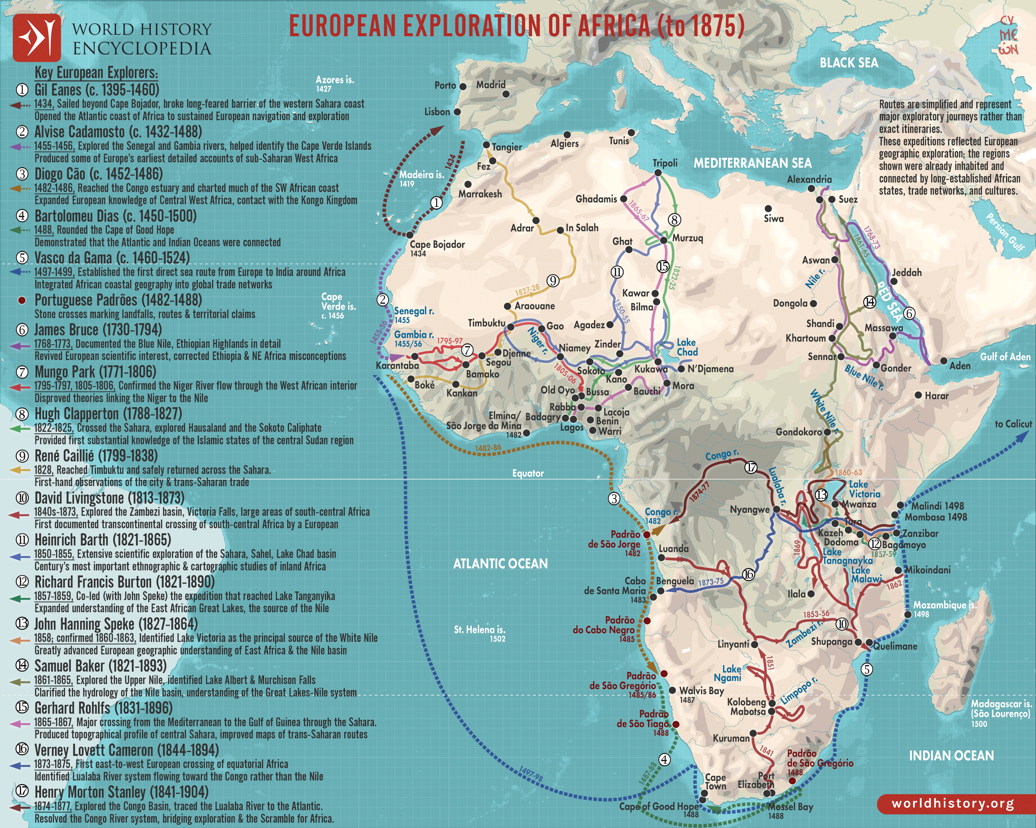
From the voyages of the Portuguese navigators under the patronage of Henry the Navigator in the 15th century to the transcontinental expeditions of Henry Morton Stanley in the 1870s, European exploration of [Africa](https://www.worldhistory.org/disambiguation/africa/) gradually transformed European geographic knowledge of the continent. Early expeditions focused primarily on maritime navigation and access to the [gold](https://www.worldhistory.org/gold/), spice, and Indian Ocean [trade](https://www.worldhistory.org/disambiguation/trade/) networks. Explorers such as Gil Eanes, Bartolomeu Dias, and [Vasco da Gama](https://www.worldhistory.org/Vasco_da_Gama/) established new Atlantic and Indian Ocean sea routes during the reigns of John I of Portugal (reign 1385–1433), John II of Portugal (reign 1481–1495), and Manuel I of Portugal (reign 1495–1521). During the 18th and 19th centuries, scientific curiosity, missionary activity, commercial ambition, and competition between European states drove explorers deeper into the Sahara, the Niger Basin, the [Nile](https://www.worldhistory.org/nile/) system, and the African Great Lakes. Expeditions by Mungo Park, Heinrich Barth, Richard Francis Burton, John Hanning Speke, and David Livingstone helped resolve long-standing European geographical questions concerning the Niger River, the source of the Nile, and the river systems of Central Africa.
These expeditions did not “discover” empty lands, but rather introduced European audiences to regions already inhabited and connected by long-established African states, caravan routes, trade networks, and intellectual traditions. Explorers frequently depended on African guides, interpreters, merchants, rulers, and existing transportation corridors to survive and travel across the continent. The routes shown here therefore reflect changing European understanding of African geography rather than the first human knowledge of these regions. By the time of Stanley’s Congo expedition (1874–1877), exploration increasingly overlapped with imperial ambition and geopolitical competition, foreshadowing the Scramble for Africa formalized after the Berlin Conference.
#### Editorial Review
This human-authored image has been reviewed by our editorial team before publication to ensure accuracy, reliability and adherence to academic standards in accordance with our [editorial policy](https://www.worldhistory.org/static/editorial-policy/).
## About the Author
Simeon is a freelance visual designer and history educator, passionate about the human stories that shape the past.
- [Linkedin Profile](https://www.linkedin.com/in/simeon-netchev/)
## Cite This Work
### APA
Netchev, S. (2026, May 31). Map of European Exploration of Africa, c. 1434-1877: From Coastal Voyages to Continental Expeditions. *World History Encyclopedia*.
### Chicago
Netchev, Simeon. "Map of European Exploration of Africa, c. 1434-1877: From Coastal Voyages to Continental Expeditions." *World History Encyclopedia*, May 31, 2026. .
### MLA
Netchev, Simeon. "Map of European Exploration of Africa, c. 1434-1877: From Coastal Voyages to Continental Expeditions." *World History Encyclopedia*, 31 May 2026, .
## License & Copyright
Submitted by [Simeon Netchev](https://www.worldhistory.org/user/simeonnetchev/ "User Page: Simeon Netchev"), published on 31 May 2026. The copyright holder has published this content under the following license: [Creative Commons Attribution-NonCommercial-NoDerivs](https://creativecommons.org/licenses/by-nc/4.0deed.en). This licence only allows others to download this content and share it with others as long as the author is credited, but they can't change the content in any way or use it commercially. When republishing on the web a hyperlink back to the original content source URL must be included. Please note that content linked from this page may have different licensing terms.