---
title: Map of Southern Levant c.1200 BCE: Emerging Societies in the Early Iron Age
author: Simeon Netchev
source: https://www.worldhistory.org/image/21764/map-of-southern-levant-c1200-bce/
format: machine-readable-alternate
license: Creative Commons Attribution-NonCommercial-NoDerivs (https://creativecommons.org/licenses/by-nc/4.0)
updated: 2026-04-29
---
# Map of Southern Levant c.1200 BCE: Emerging Societies in the Early Iron Age
_Authored by [Simeon Netchev](https://www.worldhistory.org/user/simeonnetchev/)_
## Image File
[](https://www.worldhistory.org/uploads/images/21764.png)
## Image Caption
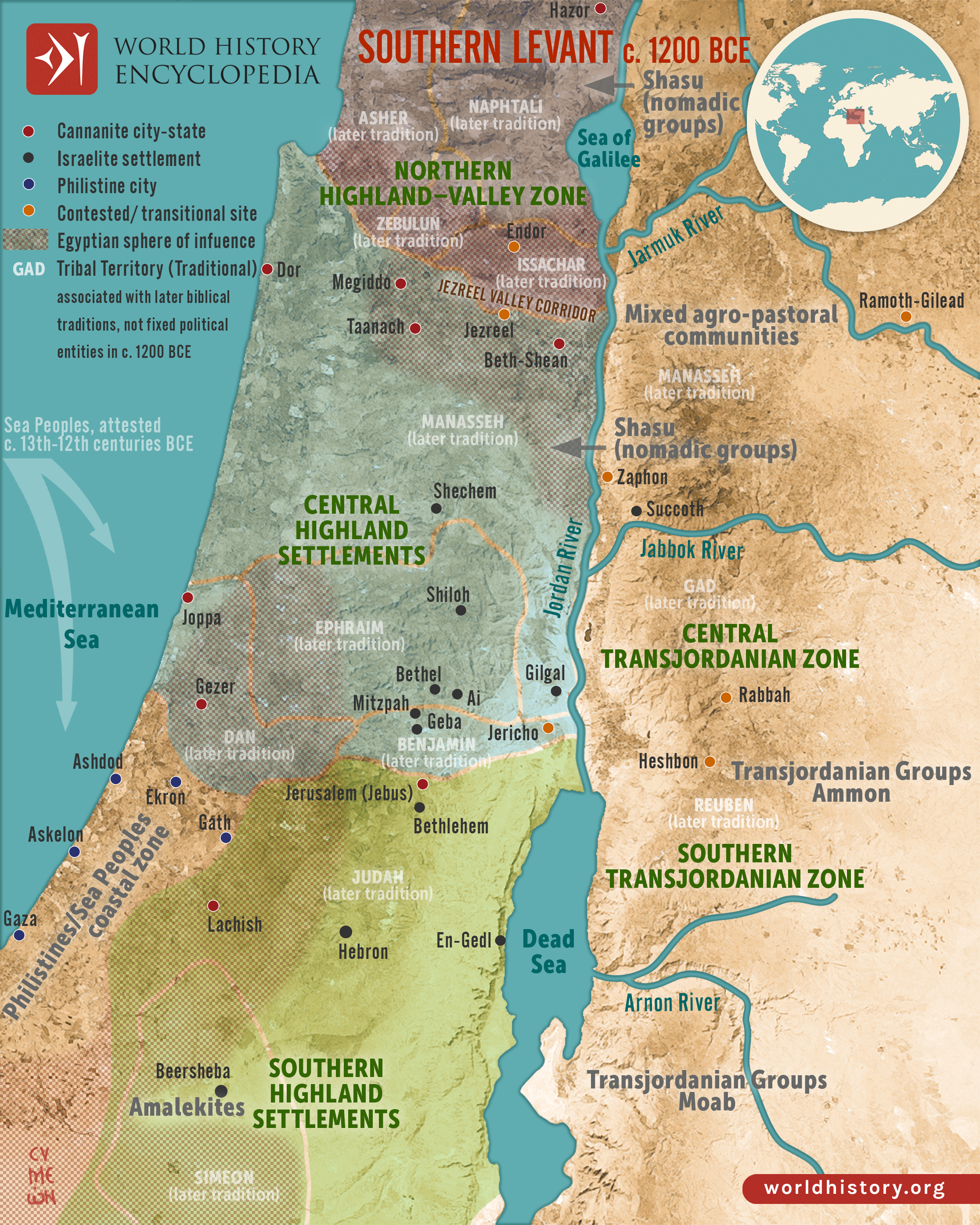
Around c. 1200 BCE, the southern [Levant](https://www.worldhistory.org/levant/) stood at a critical point of transformation following the decline of Late [Bronze Age](https://www.worldhistory.org/disambiguation/Bronze_Age/) systems. For centuries, [Egyptian](https://www.worldhistory.org/disambiguation/Egyptian/) hegemony under rulers such as [Ramesses II](https://www.worldhistory.org/Ramesses_II/) (reign 1279–1213 BCE) and his successors had structured the region through a network of Canaanite [city](https://www.worldhistory.org/city/)-states. By the late 13th and early 12th centuries BCE, this imperial framework weakened, leaving key urban centers, such as Hazor, Megiddo, and Lachish, to persist with varying degrees of autonomy, while Egyptian influence survived only in limited administrative strongholds. At the same time, coastal regions witnessed the arrival and gradual settlement of groups associated with the [Sea Peoples](https://www.worldhistory.org/Sea_Peoples/) migrations, including the [Philistines](https://www.worldhistory.org/Philistines/), marking a significant shift in the balance of power along the eastern [Mediterranean](https://www.worldhistory.org/disambiguation/mediterranean/).
Rather than clearly defined states, the region formed a [mosaic](https://www.worldhistory.org/Mosaic/) of overlapping and fluid zones. Archaeological evidence points to the growth of dispersed highland settlements in the central and southern uplands, often linked in later traditions to early Israelite identity, while the Transjordan remained dominated by fragmented agro-pastoral communities and nomadic groups, including those identified in Egyptian sources as Shasu. In this transitional landscape, older urban systems, emerging rural communities, and mobile populations coexisted, illustrating a gradual and regionally varied transformation that would shape the political and cultural developments of the Early [Iron Age](https://www.worldhistory.org/disambiguation/Iron_Age/).
*Special thanks to Patrick Scott Smith, M.A. for his research and input.*
#### Editorial Review
This human-authored image has been reviewed by our editorial team before publication to ensure accuracy, reliability and adherence to academic standards in accordance with our [editorial policy](https://www.worldhistory.org/static/editorial-policy/).
## About the Author
Simeon is a freelance visual designer and history educator, passionate about the human stories that shape the past.
- [Linkedin Profile](https://www.linkedin.com/in/simeon-netchev/)
## Cite This Work
### APA
Netchev, S. (2026, April 29). Map of Southern Levant c.1200 BCE: Emerging Societies in the Early Iron Age. *World History Encyclopedia*.
### Chicago
Netchev, Simeon. "Map of Southern Levant c.1200 BCE: Emerging Societies in the Early Iron Age." *World History Encyclopedia*, April 29, 2026. .
### MLA
Netchev, Simeon. "Map of Southern Levant c.1200 BCE: Emerging Societies in the Early Iron Age." *World History Encyclopedia*, 29 Apr 2026, .
## License & Copyright
Submitted by [Simeon Netchev](https://www.worldhistory.org/user/simeonnetchev/ "User Page: Simeon Netchev"), published on 29 April 2026. The copyright holder has published this content under the following license: [Creative Commons Attribution-NonCommercial-NoDerivs](https://creativecommons.org/licenses/by-nc/4.0deed.en). This licence only allows others to download this content and share it with others as long as the author is credited, but they can't change the content in any way or use it commercially. When republishing on the web a hyperlink back to the original content source URL must be included. Please note that content linked from this page may have different licensing terms.