---
title: Map of the Crusader States (Outremer), 1096-1291
author: Simeon Netchev
source: https://www.worldhistory.org/image/20583/map-of-the-crusader-states-outremer-1096-1291/
format: machine-readable-alternate
license: Creative Commons Attribution-NonCommercial-ShareAlike (https://creativecommons.org/licenses/by-nc-sa/4.0/)
updated: 2026-01-28
---
# Map of the Crusader States (Outremer), 1096-1291
_Authored by [Simeon Netchev](https://www.worldhistory.org/user/simeonnetchev/)_
## Image File
[](https://www.worldhistory.org/uploads/images/20583.png)
## Image Caption
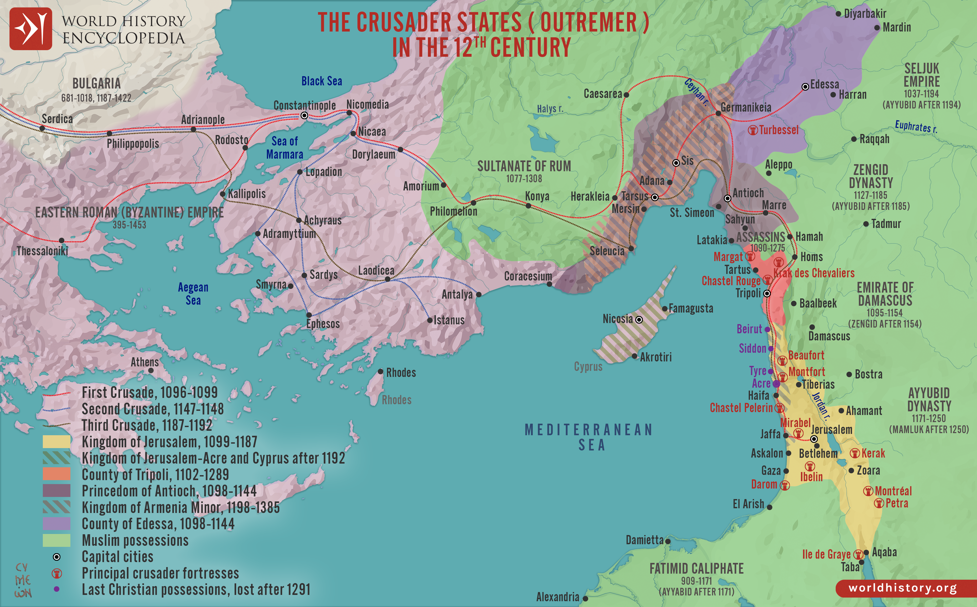
The [Crusader States](https://www.worldhistory.org/Crusader_States/), collectively known as Outremer (from Old French *outre-mer,* “overseas”), were a group of Latin Christian polities established in the eastern [Mediterranean](https://www.worldhistory.org/disambiguation/mediterranean/) following the [First Crusade](https://www.worldhistory.org/First_Crusade/) (1096–1099). Emerging from the [conquest](https://www.worldhistory.org/warfare/) of former [Byzantine](https://www.worldhistory.org/disambiguation/Byzantine/) and Muslim-ruled territories, these states expanded and consolidated during subsequent campaigns, including the [Second Crusade](https://www.worldhistory.org/Second_Crusade/) (1147–1148) and the [Third Crusade](https://www.worldhistory.org/Third_Crusade/) (1187–1192). At their height in the 12th century, Outremer comprised several distinct yet interconnected entities, most notably the [Kingdom of Jerusalem](https://www.worldhistory.org/Kingdom_of_Jerusalem/) (1099–1187), the Principality of [Antioch](https://www.worldhistory.org/Antiochia/) (1098–1144), and the County of [Edessa](https://www.worldhistory.org/edessa/) (1098–1144), stretching along the Levantine coast and into parts of [Anatolia](https://www.worldhistory.org/Asia_Minor/), with later strategic reliance on [Cyprus](https://www.worldhistory.org/cyprus/) (from 1191).
These states developed within a fragmented and highly contested political landscape shaped by interactions between Western crusaders, the Eastern [Roman](https://www.worldhistory.org/disambiguation/Roman/) (Byzantine) [Empire](https://www.worldhistory.org/empire/) (395–1453), and powerful Muslim dynasties, including the Seljuks (1037–1194), Zengids (1127–1185), and Ayyubids (from 1171). Rather than functioning as a unified empire, Outremer consisted of fortified urban centers, castles, and military corridors sustained by both overland routes and Italian maritime supply networks. Key strongholds, such as [Krak des Chevaliers](https://www.worldhistory.org/Krak_Des_Chevaliers/), Chastel Rouge, and Chastel Pèlerin, were essential to defense, communication, and control of territory.
#### Editorial Review
This human-authored image has been reviewed by our editorial team before publication to ensure accuracy, reliability and adherence to academic standards in accordance with our [editorial policy](https://www.worldhistory.org/static/editorial-policy/).
## About the Author
Simeon is a freelance visual designer and history educator, passionate about the human stories that shape the past.
- [Linkedin Profile](https://www.linkedin.com/in/simeon-netchev/)
## Cite This Work
### APA
Netchev, S. (2026, January 28). Map of the Crusader States (Outremer), 1096-1291. *World History Encyclopedia*.
### Chicago
Netchev, Simeon. "Map of the Crusader States (Outremer), 1096-1291." *World History Encyclopedia*, January 28, 2026. .
### MLA
Netchev, Simeon. "Map of the Crusader States (Outremer), 1096-1291." *World History Encyclopedia*, 28 Jan 2026, .
## License & Copyright
Submitted by [Simeon Netchev](https://www.worldhistory.org/user/simeonnetchev/ "User Page: Simeon Netchev"), published on 28 January 2026. The copyright holder has published this content under the following license: [Creative Commons Attribution-NonCommercial-ShareAlike](https://creativecommons.org/licenses/by-nc-sa/4.0/deed.en). This license lets others remix, tweak, and build upon this content non-commercially, as long as they credit the author and license their new creations under the identical terms. When republishing on the web a hyperlink back to the original content source URL must be included. Please note that content linked from this page may have different licensing terms.