---
title: Map of the World in the 14th Century
author: Simeon Netchev
source: https://www.worldhistory.org/image/20507/map-of-the-world-in-the-14th-century/
format: machine-readable-alternate
license: Creative Commons Attribution-NonCommercial-NoDerivs (https://creativecommons.org/licenses/by-nc/4.0)
updated: 2025-05-28
---
# Map of the World in the 14th Century
_Authored by [Simeon Netchev](https://www.worldhistory.org/user/simeonnetchev/)_
## Image File
[](https://www.worldhistory.org/uploads/images/20507.png)
## Image Caption
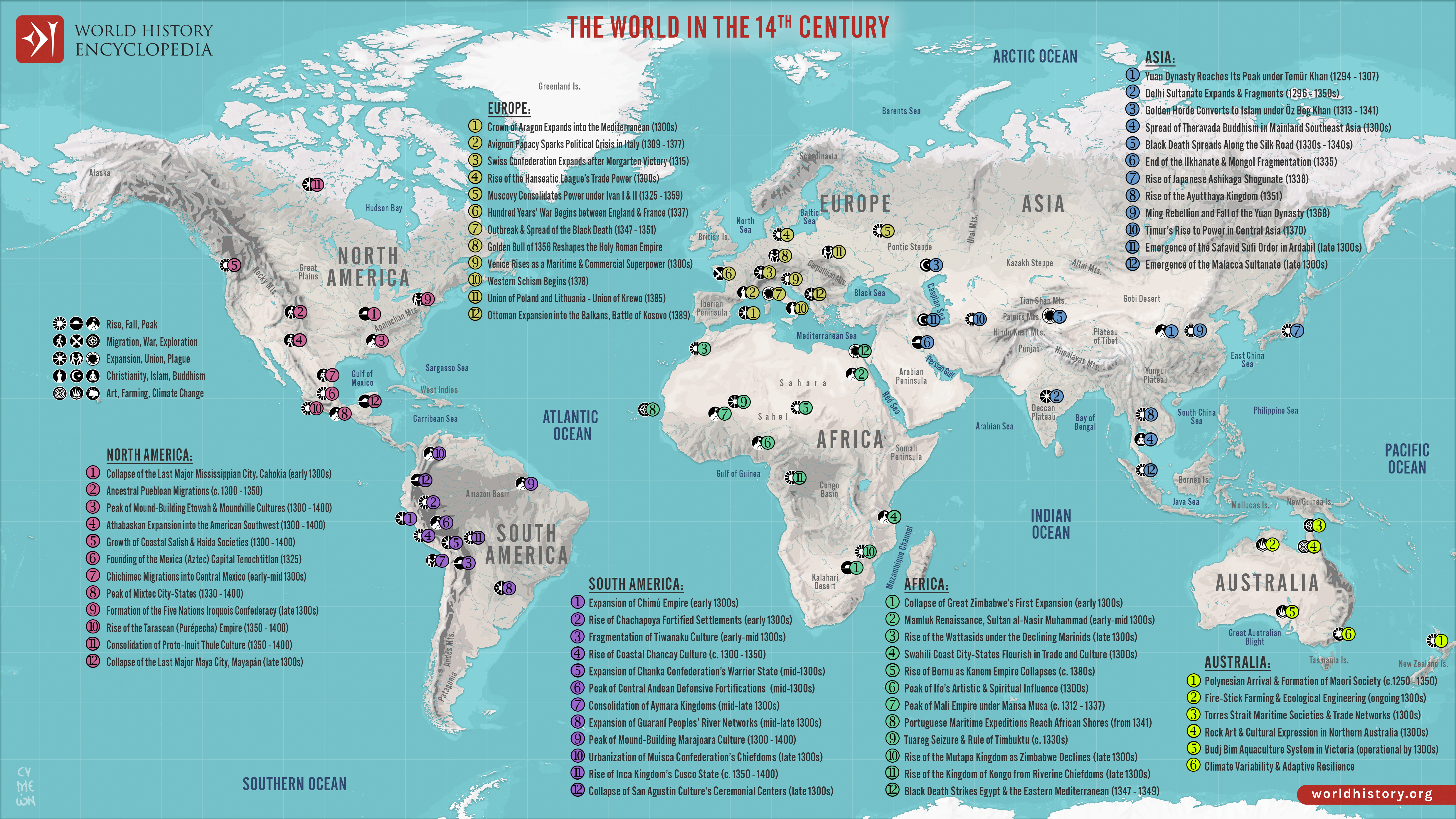
The 14th century was a time of crisis and transformation across much of the world. [Plague](https://www.worldhistory.org/disambiguation/plague/), [war](https://www.worldhistory.org/disambiguation/War/), shifting power structures, and intellectual ferment reshaped societies from Asia to [Africa](https://www.worldhistory.org/disambiguation/africa/), [Europe](https://www.worldhistory.org/europe/) to the Americas. Despite profound instability, new centers of influence emerged and long-distance connections intensified, forging an increasingly intertwined—yet fractured—global landscape.
The [Black Death](https://www.worldhistory.org/Black_Death/) swept from [China](https://www.worldhistory.org/china/) to Europe, decimating populations and disrupting economies, while the Delhi Sultanate expanded deep into the Indian subcontinent and the [Mali Empire](https://www.worldhistory.org/Mali_Empire/) reached its zenith under Mansa Musa. The [Mongol Empire](https://www.worldhistory.org/Mongol_Empire/) fractured, [Byzantium](https://www.worldhistory.org/Byzantium/) faltered, and new dynasties—like the Ming in China—rose from the wreckage. In West Africa, Islamic scholarship flourished in [Timbuktu](https://www.worldhistory.org/Timbuktu/); in the Andes, regional centers consolidated power; and in Mesoamerica, the foundations of future empires were being laid. [Trade](https://www.worldhistory.org/disambiguation/trade/) routes carried goods, stories, and contagion across continents, linking distant cultures even as their internal structures reeled from conflict and change.
#### Editorial Review
This human-authored image has been reviewed by our editorial team before publication to ensure accuracy, reliability and adherence to academic standards in accordance with our [editorial policy](https://www.worldhistory.org/static/editorial-policy/).
## About the Author
Simeon is a freelance visual designer and history educator, passionate about the human stories that shape the past.
- [Linkedin Profile](https://www.linkedin.com/in/simeon-netchev/)
## Cite This Work
### APA
Netchev, S. (2025, May 28). Map of the World in the 14th Century. *World History Encyclopedia*.
### Chicago
Netchev, Simeon. "Map of the World in the 14th Century." *World History Encyclopedia*, May 28, 2025. .
### MLA
Netchev, Simeon. "Map of the World in the 14th Century." *World History Encyclopedia*, 28 May 2025, .
## License & Copyright
Submitted by [Simeon Netchev](https://www.worldhistory.org/user/simeonnetchev/ "User Page: Simeon Netchev"), published on 28 May 2025. The copyright holder has published this content under the following license: [Creative Commons Attribution-NonCommercial-NoDerivs](https://creativecommons.org/licenses/by-nc/4.0deed.en). This licence only allows others to download this content and share it with others as long as the author is credited, but they can't change the content in any way or use it commercially. When republishing on the web a hyperlink back to the original content source URL must be included. Please note that content linked from this page may have different licensing terms.