---
title: Map of the United States on the Eve of Civil War, 1861
author: Simeon Netchev
source: https://www.worldhistory.org/image/20390/map-of-the-united-states-on-the-eve-of-civil-war-1/
format: machine-readable-alternate
license: Creative Commons Attribution-NonCommercial-NoDerivs (https://creativecommons.org/licenses/by-nc/4.0)
updated: 2025-12-10
---
# Map of the United States on the Eve of Civil War, 1861
_Authored by [Simeon Netchev](https://www.worldhistory.org/user/simeonnetchev/)_
## Image File
[](https://www.worldhistory.org/uploads/images/20390.png)
## Image Caption
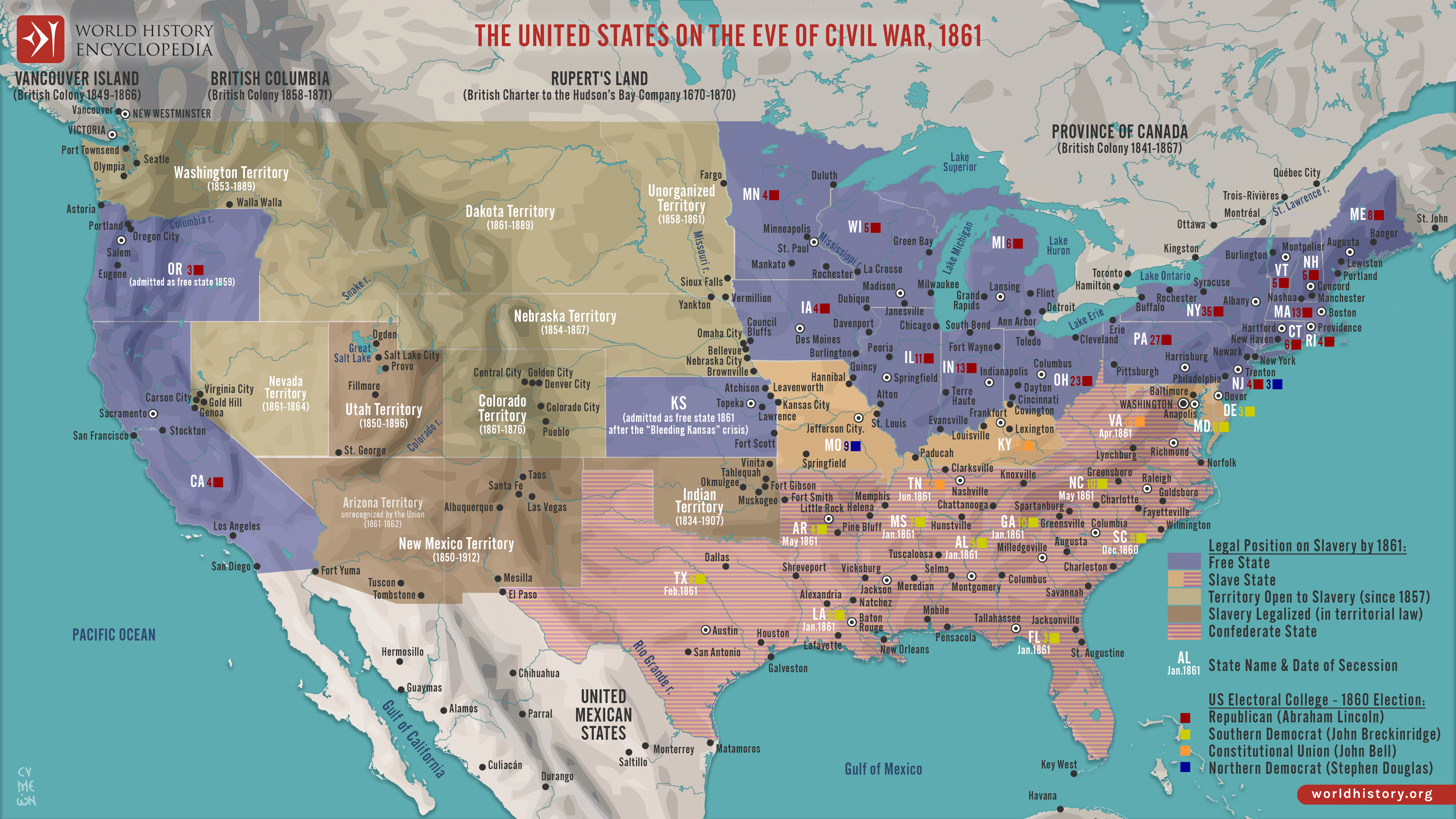
In early 1861, the United States entered the most severe constitutional and political crisis in its history. The election of [Abraham](https://www.worldhistory.org/Abraham,_the_Patriarch/) Lincoln (president 1861–1865) triggered a wave of secessions beginning with South Carolina in December 1860, as Southern leaders claimed that Republican opposition to the expansion of slavery threatened their economic and political order. The map reflects the nation at this pivotal moment, distinguishing free states, slave states, and U.S. federal territories, while also showing the early formation of the Confederate States of America (established February 1861). This spatial division underscores how regional identities had hardened over decades of conflict surrounding slavery, political representation, and federal authority.
In the months before the outbreak of [war](https://www.worldhistory.org/disambiguation/War/) at Fort Sumter (April 1861), the republic still existed formally as one nation, yet its unity had already fractured in practice. The geography of freedom and slavery, shaped by legislation such as the [Missouri Compromise](https://www.worldhistory.org/Missouri_Compromise/) (1820) and the Kansas-Nebraska Act (1854), revealed deep structural fault lines within the federal system. As states withdrew from the Union and border regions weighed their loyalties, Americans confronted an unavoidable collision between competing visions of the republic. This map captures that final, unstable moment before open conflict, when political ideology, sectional identity, and territorial realities converged to make civil war all but inevitable.
#### Editorial Review
This human-authored image has been reviewed by our editorial team before publication to ensure accuracy, reliability and adherence to academic standards in accordance with our [editorial policy](https://www.worldhistory.org/static/editorial-policy/).
## About the Author
Simeon is a freelance visual designer and history educator, passionate about the human stories that shape the past.
- [Linkedin Profile](https://www.linkedin.com/in/simeon-netchev/)
## Cite This Work
### APA
Netchev, S. (2025, April 29). Map of the United States on the Eve of Civil War, 1861. *World History Encyclopedia*.
### Chicago
Netchev, Simeon. "Map of the United States on the Eve of Civil War, 1861." *World History Encyclopedia*, April 29, 2025. .
### MLA
Netchev, Simeon. "Map of the United States on the Eve of Civil War, 1861." *World History Encyclopedia*, 29 Apr 2025, .
## License & Copyright
Submitted by [Simeon Netchev](https://www.worldhistory.org/user/simeonnetchev/ "User Page: Simeon Netchev"), published on 29 April 2025. The copyright holder has published this content under the following license: [Creative Commons Attribution-NonCommercial-NoDerivs](https://creativecommons.org/licenses/by-nc/4.0deed.en). This licence only allows others to download this content and share it with others as long as the author is credited, but they can't change the content in any way or use it commercially. When republishing on the web a hyperlink back to the original content source URL must be included. Please note that content linked from this page may have different licensing terms.