---
title: Map of the Italian Empire in 1942: The Spatial and Political Dimensions of Italian Imperialism
author: Simeon Netchev
source: https://www.worldhistory.org/image/20362/map-of-the-italian-empire-in-1942/
format: machine-readable-alternate
license: Creative Commons Attribution-NonCommercial-NoDerivs (https://creativecommons.org/licenses/by-nc/4.0)
updated: 2025-10-31
---
# Map of the Italian Empire in 1942: The Spatial and Political Dimensions of Italian Imperialism
_Authored by [Simeon Netchev](https://www.worldhistory.org/user/simeonnetchev/)_
## Image File
[](https://www.worldhistory.org/uploads/images/20362.png)
## Image Caption
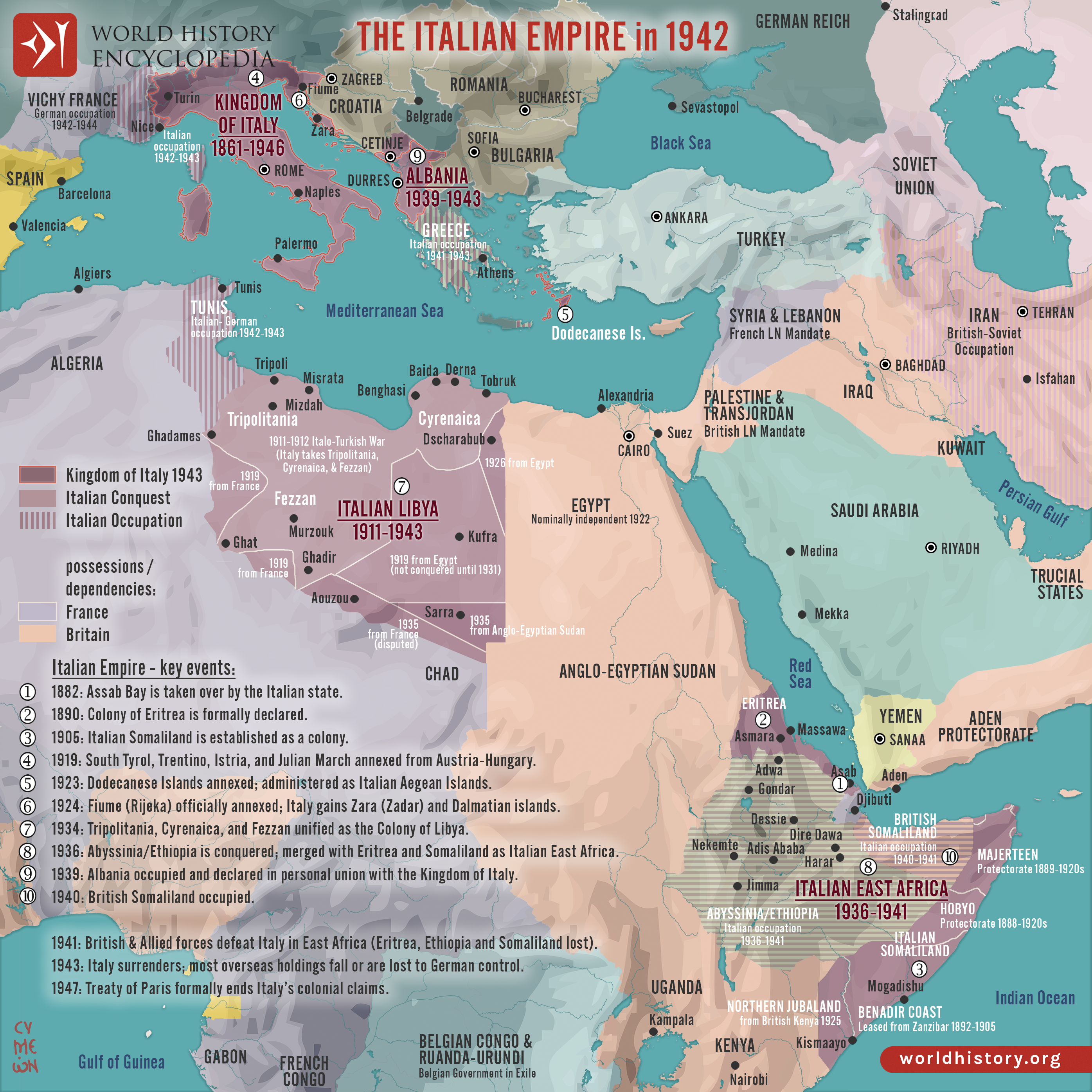
The Italian Colonial [Empire](https://www.worldhistory.org/empire/) emerged during the period of New Imperialism (late 19th–early 20th centuries) as the recently unified Kingdom of [Italy](https://www.worldhistory.org/italy/) sought to secure its place among the European great powers. Motivated by a combination of economic ambition, nationalist aspiration, and geopolitical rivalry, Italy’s colonial ventures were also a means of overcoming feelings of inferiority compared to older empires such as [Britain](https://www.worldhistory.org/disambiguation/Britain/) and France. This imperial drive reflected both the search for raw materials and new markets and the ideological rhetoric of Italy’s “civilizing mission.” Under the fascist regime of [Benito Mussolini](https://www.worldhistory.org/Benito_Mussolini/) (r. 1922–1943), imperial expansion became central to national identity and propaganda, symbolizing a vision of Italy as the heir to ancient [Rome](https://www.worldhistory.org/Rome/)’s glory.
Italy’s overseas presence began with the acquisition of Eritrea (1882) and Somaliland (1889), followed by the [conquest](https://www.worldhistory.org/warfare/) of Libya (1911) from the [Ottoman Empire](https://www.worldhistory.org/Ottoman_Empire/). The invasion of Ethiopia (1935–1936) created Italian East [Africa](https://www.worldhistory.org/disambiguation/africa/), marking the high point of Mussolini’s imperial ambitions. In [Europe](https://www.worldhistory.org/europe/), irredentist policies, claims to “unredeemed” Italian territories, led to the annexation of South Tyrol, Istria, and the Dodecanese Islands, and the occupation of Albania (1939) as well as parts of [Greece](https://www.worldhistory.org/greece/) and Dalmatia during the Second World [War](https://www.worldhistory.org/disambiguation/War/) (1939–1945). The collapse of the fascist regime and Italy’s defeat ended these ambitions; by the [Treaty of Paris](https://www.worldhistory.org/Treaty_of_Paris_of_1783/) (1947), Italy formally renounced all colonial claims, leaving behind a legacy of contested memory, limited economic gain, and enduring regional impact.
#### Editorial Review
This human-authored image has been reviewed by our editorial team before publication to ensure accuracy, reliability and adherence to academic standards in accordance with our [editorial policy](https://www.worldhistory.org/static/editorial-policy/).
## About the Author
Simeon is a freelance visual designer and history educator, passionate about the human stories that shape the past.
- [Linkedin Profile](https://www.linkedin.com/in/simeon-netchev/)
## Cite This Work
### APA
Netchev, S. (2025, April 16). Map of the Italian Empire in 1942: The Spatial and Political Dimensions of Italian Imperialism. *World History Encyclopedia*.
### Chicago
Netchev, Simeon. "Map of the Italian Empire in 1942: The Spatial and Political Dimensions of Italian Imperialism." *World History Encyclopedia*, April 16, 2025. .
### MLA
Netchev, Simeon. "Map of the Italian Empire in 1942: The Spatial and Political Dimensions of Italian Imperialism." *World History Encyclopedia*, 16 Apr 2025, .
## License & Copyright
Submitted by [Simeon Netchev](https://www.worldhistory.org/user/simeonnetchev/ "User Page: Simeon Netchev"), published on 16 April 2025. The copyright holder has published this content under the following license: [Creative Commons Attribution-NonCommercial-NoDerivs](https://creativecommons.org/licenses/by-nc/4.0deed.en). This licence only allows others to download this content and share it with others as long as the author is credited, but they can't change the content in any way or use it commercially. When republishing on the web a hyperlink back to the original content source URL must be included. Please note that content linked from this page may have different licensing terms.