---
title: Map of the African Slave Trade Networks, c. 1750: Atlantic, Trans-Saharan, Red Sea & Indian Ocean Routes
author: Simeon Netchev
source: https://www.worldhistory.org/image/20311/map-of--the-african-slave-trade-networks-c-1750/
format: machine-readable-alternate
license: Creative Commons Attribution-NonCommercial-NoDerivs (https://creativecommons.org/licenses/by-nc/4.0)
updated: 2026-09-05
---
# Map of the African Slave Trade Networks, c. 1750: Atlantic, Trans-Saharan, Red Sea & Indian Ocean Routes
_Authored by [Simeon Netchev](https://www.worldhistory.org/user/simeonnetchev/)_
## Image File
[](https://www.worldhistory.org/uploads/images/20311.png)
## Image Caption
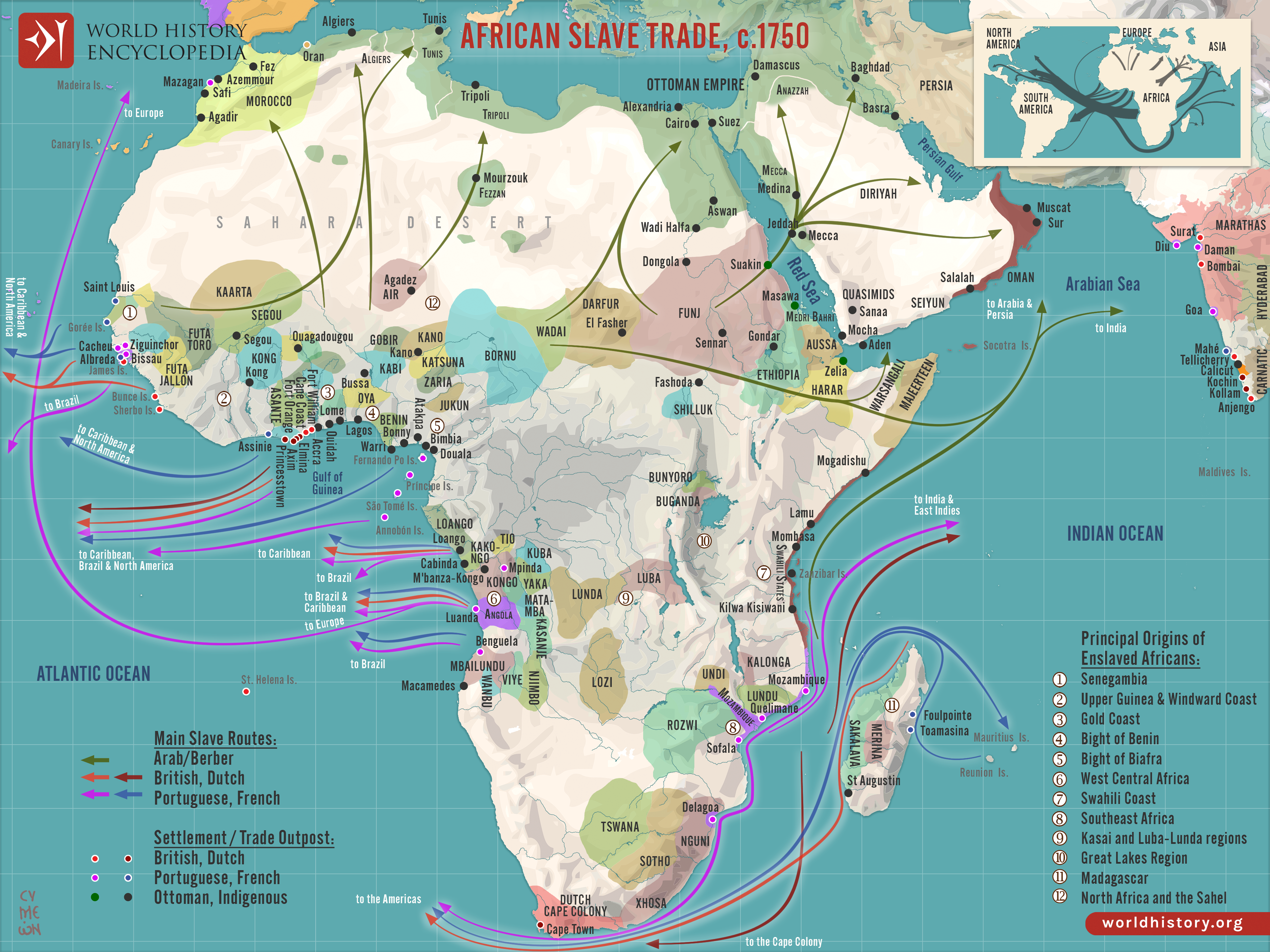
By c. 1750, the slave trades affecting [Africa](https://www.worldhistory.org/disambiguation/africa/) were entering a period of major transformation. Long-established trans-Saharan, Red Sea, and Indian Ocean networks continued to carry enslaved people toward North Africa, the Middle East, and Asia, while the [transatlantic slave trade](https://www.worldhistory.org/Transatlantic_Slave_Trade/) expanded on an unprecedented scale with the growth of plantation economies in the Americas. Their scale and character varied by region, shaped by [warfare](https://www.worldhistory.org/warfare/), political rivalry, tribute, commercial exchange, and changing overseas demand, while increasingly drawing inland societies into wider circuits of forced migration.
The consequences were uneven but profound. African rulers, merchants, and intermediaries participated in these systems in different ways, and some states gained wealth, technology, and greater political leverage. Elsewhere, competition for captives intensified raiding, displacement, insecurity, and demographic loss, contributing to long-term political instability and shifts in regional power.
#### Editorial Review
This human-authored image has been reviewed by our editorial team before publication to ensure accuracy, reliability and adherence to academic standards in accordance with our [editorial policy](https://www.worldhistory.org/static/editorial-policy/).
## About the Author
Simeon is a freelance visual designer and history educator, passionate about the human stories that shape the past.
- [Linkedin Profile](https://www.linkedin.com/in/simeon-netchev/)
## Cite This Work
### APA
Netchev, S. (2026, September 05). Map of the African Slave Trade Networks, c. 1750: Atlantic, Trans-Saharan, Red Sea & Indian Ocean Routes. *World History Encyclopedia*.
### Chicago
Netchev, Simeon. "Map of the African Slave Trade Networks, c. 1750: Atlantic, Trans-Saharan, Red Sea & Indian Ocean Routes." *World History Encyclopedia*, September 05, 2026. .
### MLA
Netchev, Simeon. "Map of the African Slave Trade Networks, c. 1750: Atlantic, Trans-Saharan, Red Sea & Indian Ocean Routes." *World History Encyclopedia*, 05 Sep 2026, .
## License & Copyright
Submitted by [Simeon Netchev](https://www.worldhistory.org/user/simeonnetchev/ "User Page: Simeon Netchev"), published on 05 September 2026. The copyright holder has published this content under the following license: [Creative Commons Attribution-NonCommercial-NoDerivs](https://creativecommons.org/licenses/by-nc/4.0deed.en). This licence only allows others to download this content and share it with others as long as the author is credited, but they can't change the content in any way or use it commercially. When republishing on the web a hyperlink back to the original content source URL must be included. Please note that content linked from this page may have different licensing terms.