---
title: Map of the African Slave Trade, c. 1750
author: Simeon Netchev
source: https://www.worldhistory.org/image/20311/map-of--the-african-slave-trade-c-1750/
format: machine-readable-alternate
license: Creative Commons Attribution-NonCommercial-NoDerivs (https://creativecommons.org/licenses/by-nc/4.0)
updated: 2025-11-21
---
# Map of the African Slave Trade, c. 1750
_Authored by [Simeon Netchev](https://www.worldhistory.org/user/simeonnetchev/)_
## Image File
[](https://www.worldhistory.org/uploads/images/20311.png)
## Image Caption
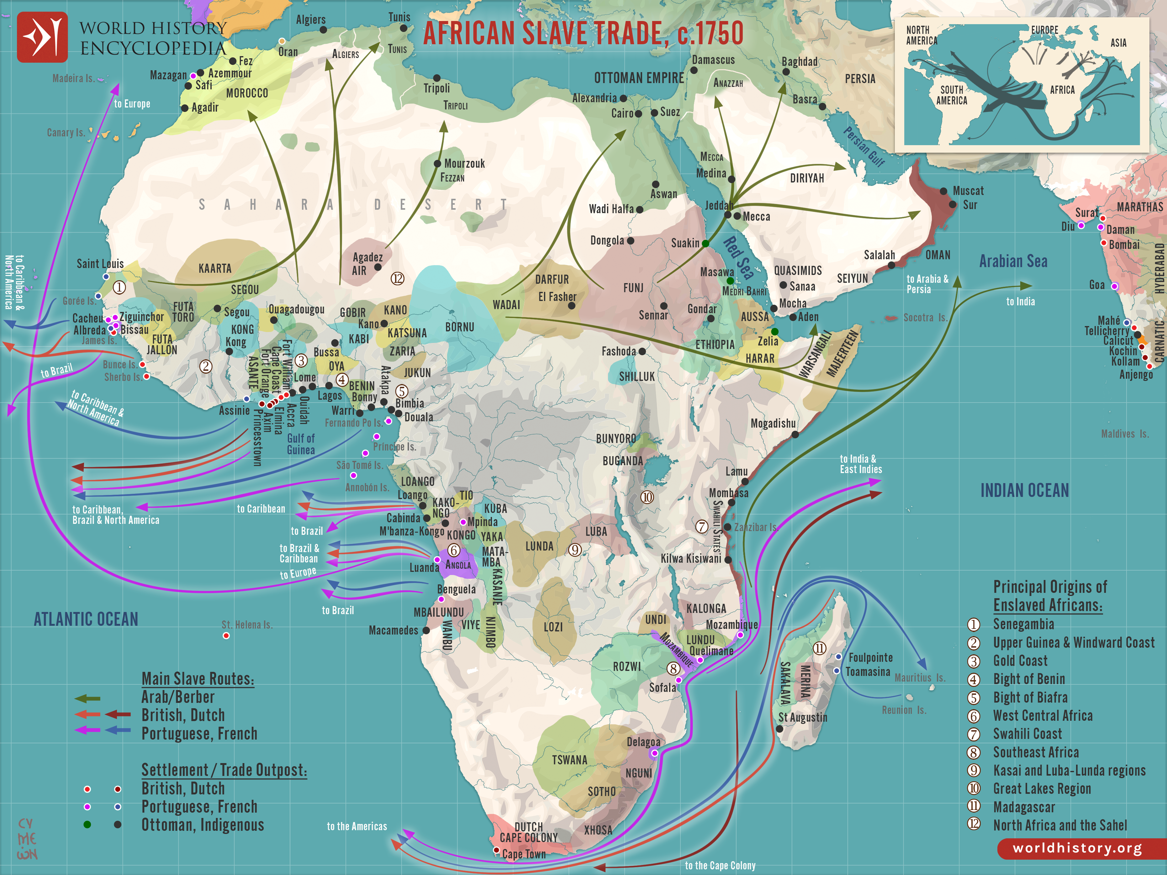
By c. 1750, [Africa](https://www.worldhistory.org/disambiguation/africa/) stood at the center of three major slave-trading systems, the transatlantic, trans-Saharan, and Indian Ocean trades, each connecting African societies to wider global economies. These networks operated simultaneously but unevenly across regions, drawing in West Africa, Central Africa, the Sahel, and the [Swahili Coast](https://www.worldhistory.org/Swahili_Coast/) through shifting political alliances, [warfare](https://www.worldhistory.org/warfare/), and commercial incentives. The scale and direction of each [trade](https://www.worldhistory.org/disambiguation/trade/) reflected long-term regional dynamics as well as the expanding economic ambitions of European, Middle Eastern, and Asian powers.
In West and Central Africa, the [transatlantic slave trade](https://www.worldhistory.org/Transatlantic_Slave_Trade/) became dominant, driven by European demand for plantation labor in the Americas. States such as Dahomey, Oyo, and Kongo captured and sold captives in exchange for firearms, textiles, alcohol, and manufactured goods, while coastal hubs like Elmina and Luanda functioned as major export centers. On the Swahili Coast, merchants from Zanzibar, [Kilwa](https://www.worldhistory.org/Kilwa/), and Mombasa traded enslaved people across the Indian Ocean to [Arabia](https://www.worldhistory.org/Arabia/), [Persia](https://www.worldhistory.org/Persia/), and [India](https://www.worldhistory.org/india/), continuing older commercial links. Meanwhile, trans-Saharan routes connected inland powers, including the Bornu [Empire](https://www.worldhistory.org/empire/) and [Hausaland](https://www.worldhistory.org/Hausaland/), to North African markets in Tripoli, Tunis, and Cairo. Together, these systems reshaped African political economies: some states centralized and expanded through participation, others experienced intensified warfare and raiding, and many regions reoriented toward export-driven structures. The combined effect was a profound redistribution of power, population, and economic resources across the continent.
#### Editorial Review
This human-authored image has been reviewed by our editorial team before publication to ensure accuracy, reliability and adherence to academic standards in accordance with our [editorial policy](https://www.worldhistory.org/static/editorial-policy/).
## About the Author
Simeon is a freelance visual designer and history educator, passionate about the human stories that shape the past.
- [Linkedin Profile](https://www.linkedin.com/in/simeon-netchev/)
## Cite This Work
### APA
Netchev, S. (2025, April 08). Map of the African Slave Trade, c. 1750. *World History Encyclopedia*.
### Chicago
Netchev, Simeon. "Map of the African Slave Trade, c. 1750." *World History Encyclopedia*, April 08, 2025. .
### MLA
Netchev, Simeon. "Map of the African Slave Trade, c. 1750." *World History Encyclopedia*, 08 Apr 2025, .
## License & Copyright
Submitted by [Simeon Netchev](https://www.worldhistory.org/user/simeonnetchev/ "User Page: Simeon Netchev"), published on 08 April 2025. The copyright holder has published this content under the following license: [Creative Commons Attribution-NonCommercial-NoDerivs](https://creativecommons.org/licenses/by-nc/4.0deed.en). This licence only allows others to download this content and share it with others as long as the author is credited, but they can't change the content in any way or use it commercially. When republishing on the web a hyperlink back to the original content source URL must be included. Please note that content linked from this page may have different licensing terms.