---
title: Map of the Trade in the Indian Ocean 15th-16th century: From Afro-Asian Exchange to European Intervention
author: Simeon Netchev
source: https://www.worldhistory.org/image/20178/map-of-the-trade-in-the-indian-ocean-15th-16th-cen/
format: machine-readable-alternate
license: Creative Commons Attribution-NonCommercial-NoDerivs (https://creativecommons.org/licenses/by-nc/4.0)
updated: 2026-03-27
---
# Map of the Trade in the Indian Ocean 15th-16th century: From Afro-Asian Exchange to European Intervention
_Authored by [Simeon Netchev](https://www.worldhistory.org/user/simeonnetchev/)_
## Image File
[](https://www.worldhistory.org/uploads/images/20178.png)
## Image Caption
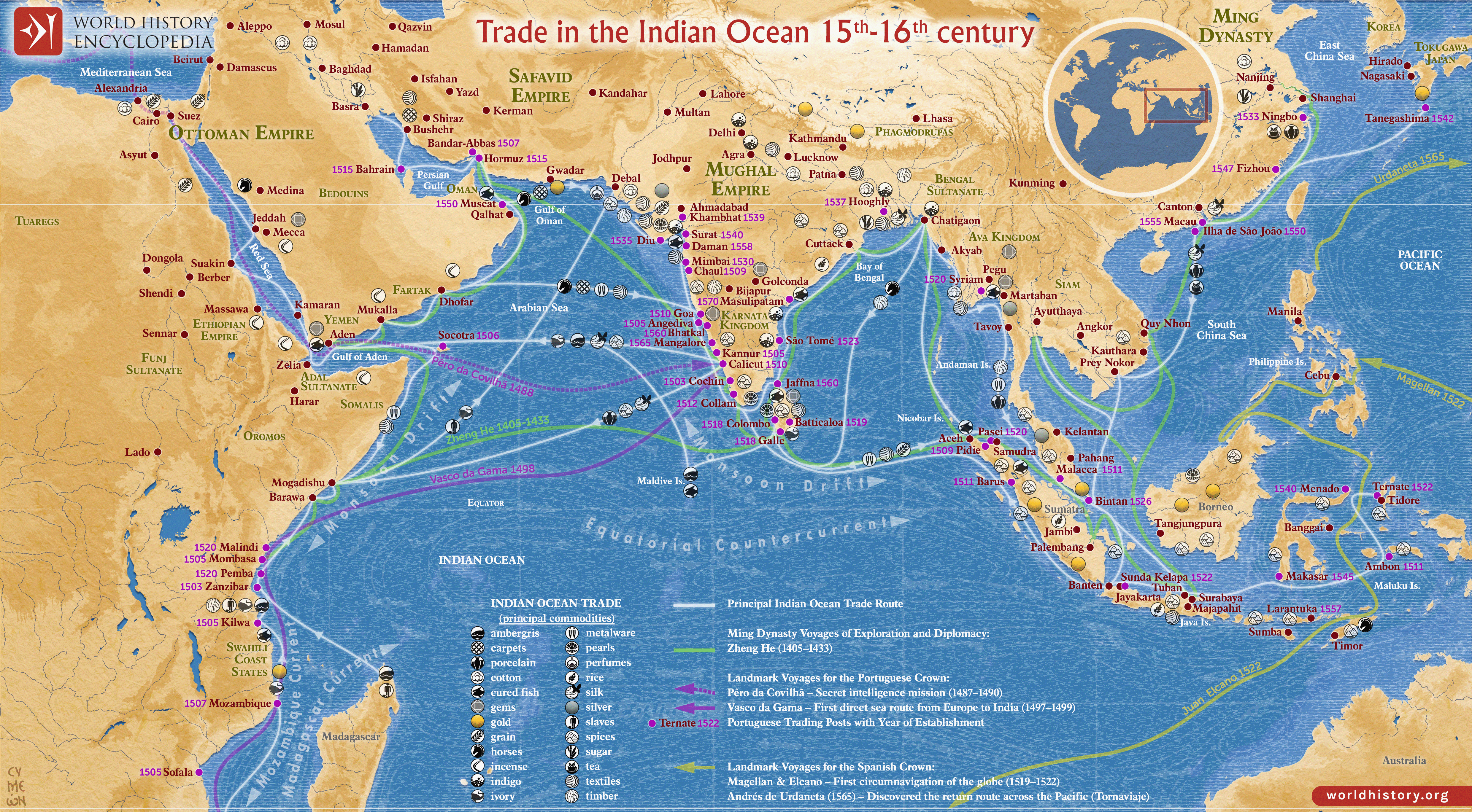
The Indian Ocean [trade](https://www.worldhistory.org/disambiguation/trade/) network of the 15th and 16th centuries formed one of the most extensive and dynamic systems of exchange in the premodern world, linking East [Africa](https://www.worldhistory.org/disambiguation/africa/), the Middle East, South Asia, and Southeast Asia. This maritime system facilitated the circulation of spices, textiles, metals, timber, and luxury goods, sustained by long-established commercial traditions dominated by Arab, Persian, Indian, and Southeast Asian merchants. Key port [cities](https://www.worldhistory.org/city/) such as Calicut, Malacca, Hormuz, and Aden functioned as major nodes of redistribution and cultural interaction. The system was further shaped by regional powers, including the [Ottoman Empire](https://www.worldhistory.org/Ottoman_Empire/), whose rulers [Mehmed II](https://www.worldhistory.org/Mehmed_II/) (reign 1451–1481) and [Suleiman the Magnificent](https://www.worldhistory.org/Suleiman_the_Magnificent/) (reign 1520–1566) controlled key overland and maritime routes through the eastern [Mediterranean](https://www.worldhistory.org/disambiguation/mediterranean/), Red Sea, and Persian Gulf, linking Indian Ocean commerce with wider Eurasian trade networks.
From the late 15th century, this established system was increasingly challenged by European maritime expansion. The arrival of the Portuguese following [Vasco da Gama](https://www.worldhistory.org/Vasco_da_Gama/)’s voyage to [India](https://www.worldhistory.org/india/) marked the beginning of direct European participation in Indian Ocean trade. Through the use of armed fleets, fortified ports, and attempts to control key choke points, the Portuguese sought to impose monopolies over high-value commodities, especially spices. They were later joined by other European powers, including the Spanish and the Dutch, whose commercial and military strategies gradually altered existing patterns of exchange.
#### Editorial Review
This human-authored image has been reviewed by our editorial team before publication to ensure accuracy, reliability and adherence to academic standards in accordance with our [editorial policy](https://www.worldhistory.org/static/editorial-policy/).
## About the Author
Simeon is a freelance visual designer and history educator, passionate about the human stories that shape the past.
- [Linkedin Profile](https://www.linkedin.com/in/simeon-netchev/)
## Cite This Work
### APA
Netchev, S. (2025, March 12). Map of the Trade in the Indian Ocean 15th-16th century: From Afro-Asian Exchange to European Intervention. *World History Encyclopedia*.
### Chicago
Netchev, Simeon. "Map of the Trade in the Indian Ocean 15th-16th century: From Afro-Asian Exchange to European Intervention." *World History Encyclopedia*, March 12, 2025. .
### MLA
Netchev, Simeon. "Map of the Trade in the Indian Ocean 15th-16th century: From Afro-Asian Exchange to European Intervention." *World History Encyclopedia*, 12 Mar 2025, .
## License & Copyright
Submitted by [Simeon Netchev](https://www.worldhistory.org/user/simeonnetchev/ "User Page: Simeon Netchev"), published on 12 March 2025. The copyright holder has published this content under the following license: [Creative Commons Attribution-NonCommercial-NoDerivs](https://creativecommons.org/licenses/by-nc/4.0deed.en). This licence only allows others to download this content and share it with others as long as the author is credited, but they can't change the content in any way or use it commercially. When republishing on the web a hyperlink back to the original content source URL must be included. Please note that content linked from this page may have different licensing terms.