---
title: Map of Thor Heyerdahl’s Kon-Tiki Expedition, 1947
author: Simeon Netchev
source: https://www.worldhistory.org/image/20099/map-of-thor-heyerdahls-kon-tiki-expedition-1947/
format: machine-readable-alternate
license: Creative Commons Attribution-NonCommercial-NoDerivs (https://creativecommons.org/licenses/by-nc/4.0)
updated: 2026-01-05
---
# Map of Thor Heyerdahl’s Kon-Tiki Expedition, 1947
_Authored by [Simeon Netchev](https://www.worldhistory.org/user/simeonnetchev/)_
## Image File
[](https://www.worldhistory.org/uploads/images/20099.png)
## Image Caption
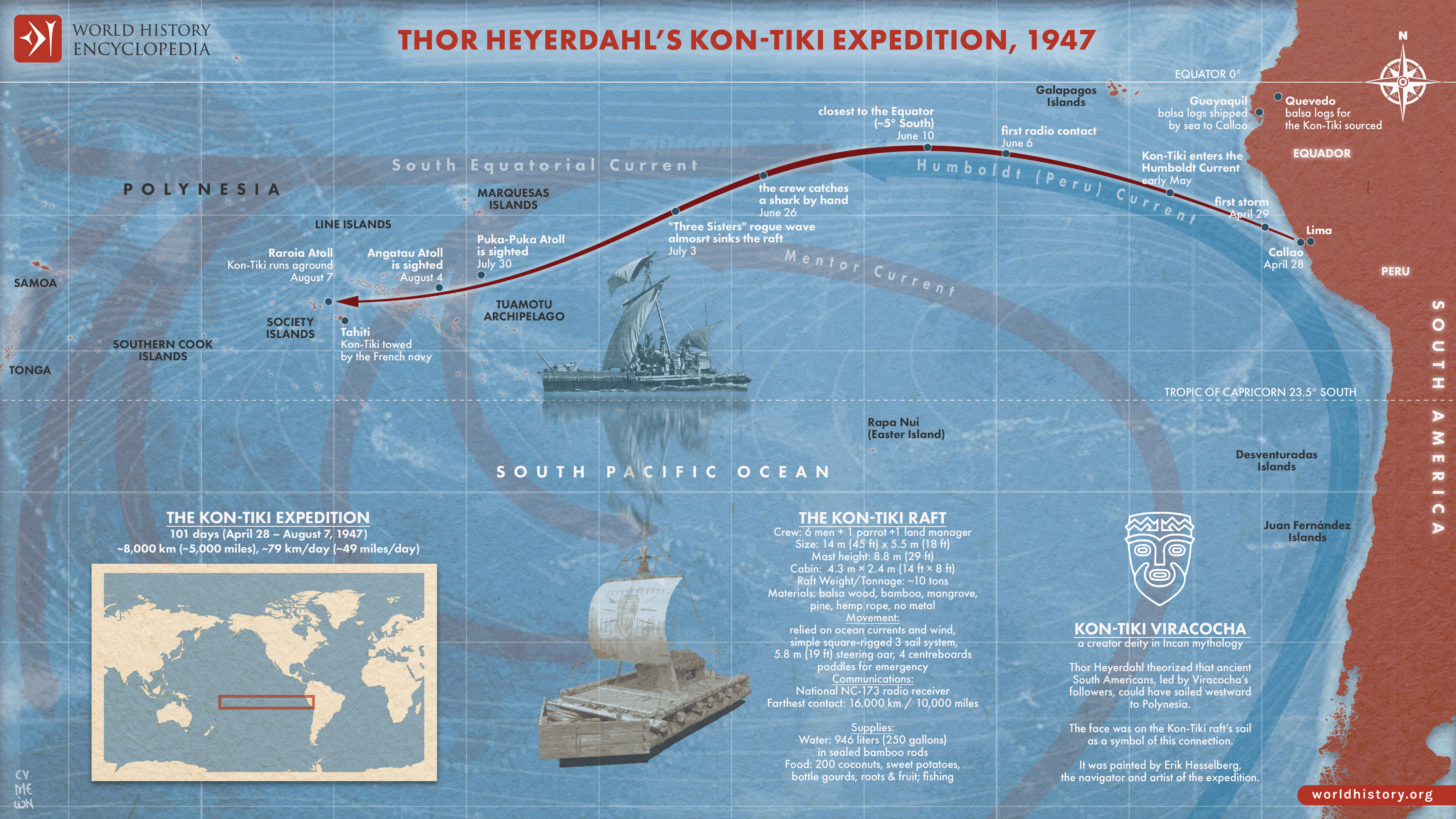
The [Kon-Tiki Expedition](https://www.worldhistory.org/Kon-Tiki_Expedition/) (1947) was an experimental voyage led by Norwegian explorer [Thor](https://www.worldhistory.org/Thor/) Heyerdahl (1914–2002), designed to test the feasibility of long-distance ocean travel using ancient technologies. Departing from Callao, Peru, a crew of six sailed a balsa-wood raft constructed with pre-modern materials and techniques, navigating the Pacific Ocean using winds and currents rather than modern propulsion. The expedition reflected a postwar surge in interest in human migration, experimental [archaeology](https://www.worldhistory.org/Archaeology/), and the practical limits of early seafaring.
Over 101 days, the Kon-Tiki traveled approximately 8,000 km (5,000 miles) before reaching Raroia Atoll in the Tuamotu Islands. Heyerdahl’s aim was not to prove that Polynesia was settled from South America (a claim now rejected by genetic, linguistic, and archaeological evidence), but to demonstrate that such a journey was technically possible. In this respect, the expedition succeeded: it showed that prehistoric technologies could sustain intercontinental travel under favorable conditions. The Kon-Tiki thus remains a landmark in experimental archaeology, illustrating how empirical testing can complement historical and scientific inquiry, even when original hypotheses are later revised.
#### Editorial Review
This human-authored image has been reviewed by our editorial team before publication to ensure accuracy, reliability and adherence to academic standards in accordance with our [editorial policy](https://www.worldhistory.org/static/editorial-policy/).
## About the Author
Simeon is a freelance visual designer and history educator, passionate about the human stories that shape the past.
- [Linkedin Profile](https://www.linkedin.com/in/simeon-netchev/)
## Cite This Work
### APA
Netchev, S. (2025, February 26). Map of Thor Heyerdahl’s Kon-Tiki Expedition, 1947. *World History Encyclopedia*.
### Chicago
Netchev, Simeon. "Map of Thor Heyerdahl’s Kon-Tiki Expedition, 1947." *World History Encyclopedia*, February 26, 2025. .
### MLA
Netchev, Simeon. "Map of Thor Heyerdahl’s Kon-Tiki Expedition, 1947." *World History Encyclopedia*, 26 Feb 2025, .
## License & Copyright
Submitted by [Simeon Netchev](https://www.worldhistory.org/user/simeonnetchev/ "User Page: Simeon Netchev"), published on 26 February 2025. The copyright holder has published this content under the following license: [Creative Commons Attribution-NonCommercial-NoDerivs](https://creativecommons.org/licenses/by-nc/4.0deed.en). This licence only allows others to download this content and share it with others as long as the author is credited, but they can't change the content in any way or use it commercially. When republishing on the web a hyperlink back to the original content source URL must be included. Please note that content linked from this page may have different licensing terms.