---
title: Map of Roman Gaul from Conquest to Integration, c. 200 CE: Provincial Order and Frontier Power in the Roman West
author: Simeon Netchev
source: https://www.worldhistory.org/image/19880/map-of-roman-gaul-from-conquest-to-integration-c-2/
format: machine-readable-alternate
license: Creative Commons Attribution-NonCommercial-NoDerivs (https://creativecommons.org/licenses/by-nc/4.0)
updated: 2026-03-26
---
# Map of Roman Gaul from Conquest to Integration, c. 200 CE: Provincial Order and Frontier Power in the Roman West
_Authored by [Simeon Netchev](https://www.worldhistory.org/user/simeonnetchev/)_
## Image File
[](https://www.worldhistory.org/uploads/images/19880.png)
## Image Caption
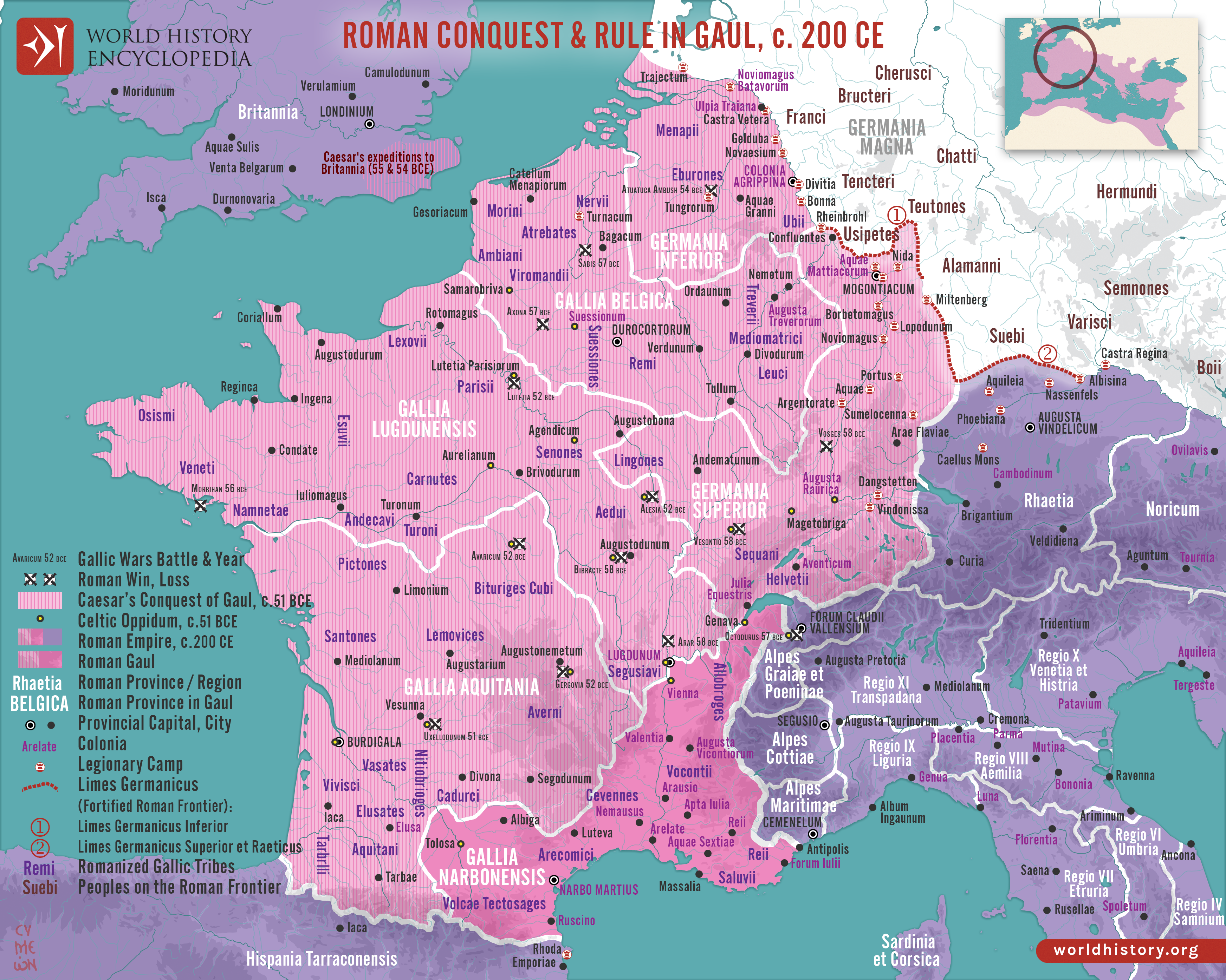
The [Roman](https://www.worldhistory.org/disambiguation/Roman/) incorporation of [Gaul](https://www.worldhistory.org/gaul/) began with the campaigns of [Julius Caesar](https://www.worldhistory.org/Julius_Caesar/) (58–51 BCE) and resulted in the gradual transformation of a diverse [Celtic](https://www.worldhistory.org/celt/) region into an integral part of the Roman world. By c. 200 CE, Gaul was organized into a structured provincial system including [Gallia](https://www.worldhistory.org/gaul/) Narbonensis, Gallia Lugdunensis, Gallia Belgica, and the frontier provinces of Germania Inferior and Germania Superior. These northern provinces were closely tied to the Limes [Germanicus](https://www.worldhistory.org/Germanicus/), the fortified frontier along the Rhine that marked both a military boundary and a zone of interaction with non-Roman peoples. This administrative framework reflects the broader Roman approach to governance: combining direct rule, local elites, and military presence to secure stability and integrate newly conquered territories.
Over the following two centuries, Roman rule reshaped Gaul through [urbanization](https://www.worldhistory.org/urbanization/), infrastructure, and cultural exchange. Major centers such as Lugdunum (Lyon) emerged as administrative capitals and hubs of imperial authority, while an extensive network of roads facilitated [trade](https://www.worldhistory.org/disambiguation/trade/), communication, and troop movement. The spread of Latin language, [Roman law](https://www.worldhistory.org/Roman_Law/), and civic institutions coexisted with enduring local traditions, producing a distinctive Gallo-Roman [culture](https://www.worldhistory.org/disambiguation/culture/). Economically, Gaul became a vital region for [agriculture](https://www.worldhistory.org/disambiguation/Agriculture/), artisanal production, and military recruitment.
#### Editorial Review
This human-authored image has been reviewed by our editorial team before publication to ensure accuracy, reliability and adherence to academic standards in accordance with our [editorial policy](https://www.worldhistory.org/static/editorial-policy/).
## About the Author
Simeon is a freelance visual designer and history educator, passionate about the human stories that shape the past.
- [Linkedin Profile](https://www.linkedin.com/in/simeon-netchev/)
## Cite This Work
### APA
Netchev, S. (2025, January 16). Map of Roman Gaul from Conquest to Integration, c. 200 CE: Provincial Order and Frontier Power in the Roman West. *World History Encyclopedia*.
### Chicago
Netchev, Simeon. "Map of Roman Gaul from Conquest to Integration, c. 200 CE: Provincial Order and Frontier Power in the Roman West." *World History Encyclopedia*, January 16, 2025. .
### MLA
Netchev, Simeon. "Map of Roman Gaul from Conquest to Integration, c. 200 CE: Provincial Order and Frontier Power in the Roman West." *World History Encyclopedia*, 16 Jan 2025, .
## License & Copyright
Submitted by [Simeon Netchev](https://www.worldhistory.org/user/simeonnetchev/ "User Page: Simeon Netchev"), published on 16 January 2025. The copyright holder has published this content under the following license: [Creative Commons Attribution-NonCommercial-NoDerivs](https://creativecommons.org/licenses/by-nc/4.0deed.en). This licence only allows others to download this content and share it with others as long as the author is credited, but they can't change the content in any way or use it commercially. When republishing on the web a hyperlink back to the original content source URL must be included. Please note that content linked from this page may have different licensing terms.