---
title: Map of the Bosporan Kingdom, c.100 CE: Gateway Between Steppe, Caucasus, and Rome
author: Simeon Netchev
source: https://www.worldhistory.org/image/19765/map-of-the-bosporan-kingdom-c100-ce/
format: machine-readable-alternate
license: Creative Commons Attribution-NonCommercial-NoDerivs (https://creativecommons.org/licenses/by-nc/4.0)
updated: 2026-03-31
---
# Map of the Bosporan Kingdom, c.100 CE: Gateway Between Steppe, Caucasus, and Rome
_Authored by [Simeon Netchev](https://www.worldhistory.org/user/simeonnetchev/)_
## Image File
[](https://www.worldhistory.org/uploads/images/19765.png)
## Image Caption
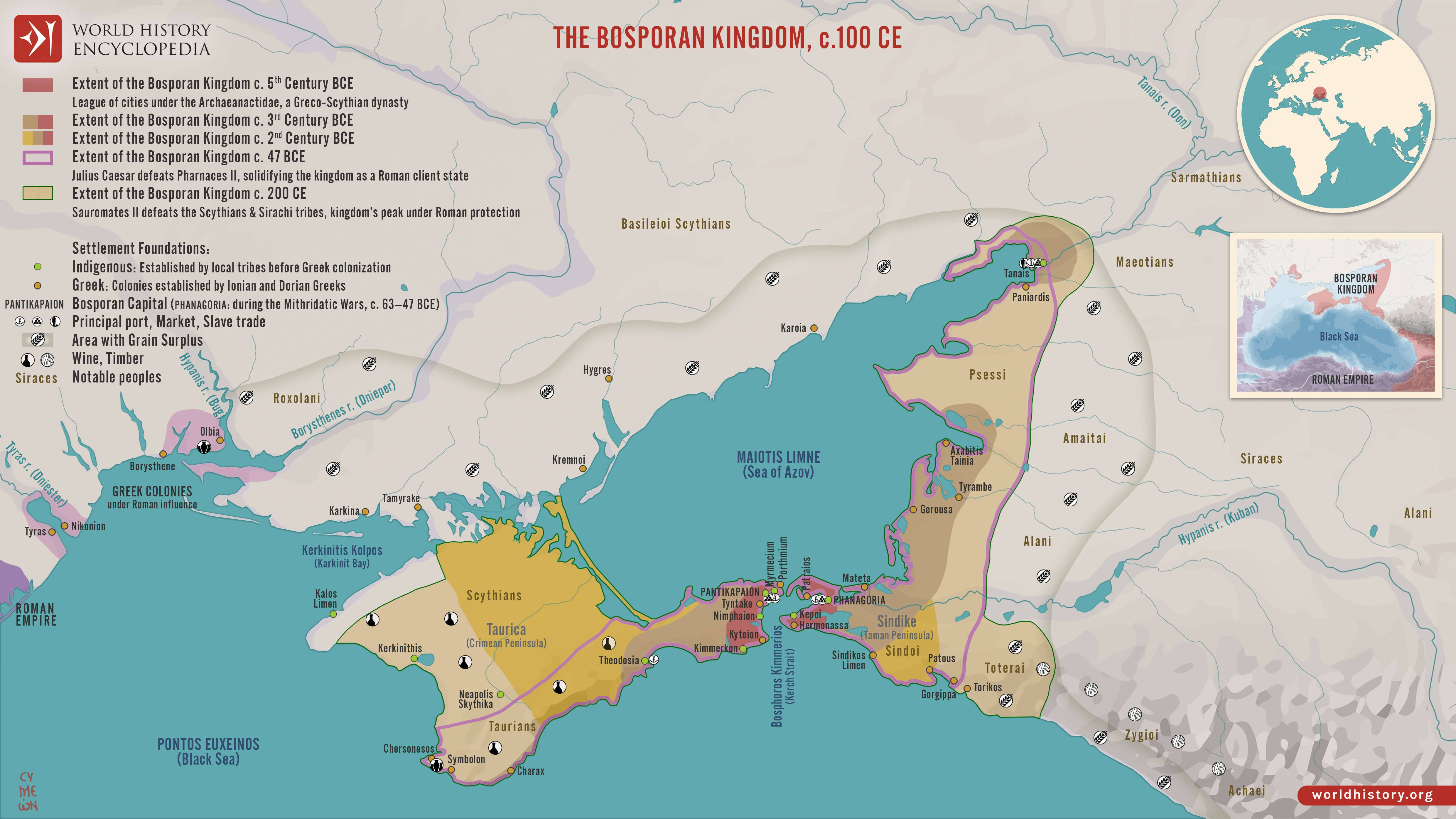
The Bosporan Kingdom (c. 480 BCE–341 CE) emerged around the Cimmerian Bosporus (modern Kerch Strait) as a hybrid Greco-local state founded by [Greek](https://www.worldhistory.org/disambiguation/greek/) colonists from [cities](https://www.worldhistory.org/city/) such as Miletus. Rather than a single unified polity in the modern sense, it developed as a network of coastal cities, agricultural hinterlands, and allied territories linking the northern Black Sea to the wider Greek world. Early rule under the Archaeanactid dynasty (c. 480–438 BCE) gave way to the Spartocid dynasty (438–110 BCE), which consolidated authority and transformed the kingdom into a major supplier of grain, fish, timber, and slaves, particularly to the [Aegean](https://www.worldhistory.org/aegean/). Positioned between steppe and sea, the Bosporan state functioned as a key intermediary zone of exchange, where Greek urban [culture](https://www.worldhistory.org/disambiguation/culture/) interacted with [Scythian](https://www.worldhistory.org/Scythians/) and other local traditions.
In the late [Hellenistic period](https://www.worldhistory.org/Hellenistic_Period/), the kingdom became entangled in the ambitions of [Mithridates VI](https://www.worldhistory.org/Mithridates_VI/) of Pontus (reign 120–63 BCE) before emerging as a [Roman](https://www.worldhistory.org/disambiguation/Roman/) client state by the mid-1st century BCE. Under rulers such as [Tiberius](https://www.worldhistory.org/Tiberius/) [Julius](https://www.worldhistory.org/disambiguation/Julius/) Aspurgus (reign 8 BCE–38 CE), a dynastic line developed that blended Greek and local identities, reflecting the region’s role as a cultural crossroads. Supported by [Rome](https://www.worldhistory.org/Rome/) yet retaining internal autonomy, the kingdom prospered for several centuries as part of the wider Black Sea economic system. From the 3rd century CE onward, however, increasing pressure from groups such as the [Goths](https://www.worldhistory.org/Goths/) and Alans, followed by the [Huns](https://www.worldhistory.org/Huns/) in the 370s CE, destabilized the region. By 341 CE, the Bosporan Kingdom had ceased to exist as an independent political entity, marking the end of one of the longest-lasting states of the ancient Black Sea world.
#### Editorial Review
This human-authored image has been reviewed by our editorial team before publication to ensure accuracy, reliability and adherence to academic standards in accordance with our [editorial policy](https://www.worldhistory.org/static/editorial-policy/).
## About the Author
Simeon is a freelance visual designer and history educator, passionate about the human stories that shape the past.
- [Linkedin Profile](https://www.linkedin.com/in/simeon-netchev/)
## Cite This Work
### APA
Netchev, S. (2026, March 31). Map of the Bosporan Kingdom, c.100 CE: Gateway Between Steppe, Caucasus, and Rome. *World History Encyclopedia*.
### Chicago
Netchev, Simeon. "Map of the Bosporan Kingdom, c.100 CE: Gateway Between Steppe, Caucasus, and Rome." *World History Encyclopedia*, March 31, 2026. .
### MLA
Netchev, Simeon. "Map of the Bosporan Kingdom, c.100 CE: Gateway Between Steppe, Caucasus, and Rome." *World History Encyclopedia*, 31 Mar 2026, .
## License & Copyright
Submitted by [Simeon Netchev](https://www.worldhistory.org/user/simeonnetchev/ "User Page: Simeon Netchev"), published on 31 March 2026. The copyright holder has published this content under the following license: [Creative Commons Attribution-NonCommercial-NoDerivs](https://creativecommons.org/licenses/by-nc/4.0deed.en). This licence only allows others to download this content and share it with others as long as the author is credited, but they can't change the content in any way or use it commercially. When republishing on the web a hyperlink back to the original content source URL must be included. Please note that content linked from this page may have different licensing terms.