---
title: Map of the U.S. Presidential Election of 1800
author: Simeon Netchev
source: https://www.worldhistory.org/image/19611/map-of-the-us-presidential-election-of-1800/
format: machine-readable-alternate
license: Creative Commons Attribution-NonCommercial-NoDerivs (https://creativecommons.org/licenses/by-nc/4.0)
updated: 2025-06-03
---
# Map of the U.S. Presidential Election of 1800
_Authored by [Simeon Netchev](https://www.worldhistory.org/user/simeonnetchev/)_
## Image File
[](https://www.worldhistory.org/uploads/images/19611.png)
## Image Caption
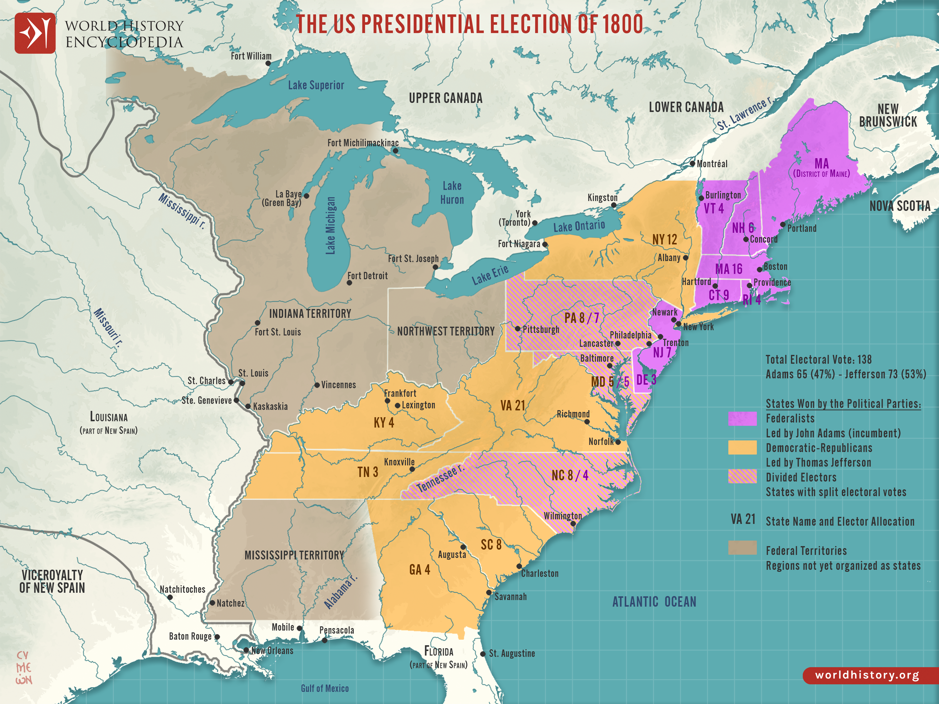
This map illustrates the fiercely contested U.S. presidential election of 1800, pitting Federalist incumbent [John Adams](https://www.worldhistory.org/John_Adams/) against Democratic-Republican [Thomas Jefferson](https://www.worldhistory.org/Thomas_Jefferson/). An electoral tie with running mate [Aaron Burr](https://www.worldhistory.org/Aaron_Burr/) sent the decision to the House, where Jefferson prevailed after 36 ballots, proving the nation could transfer power peacefully.
Behind the drama lay stark ideological rifts: Federalists favored centralized authority and closer ties to [Britain](https://www.worldhistory.org/disambiguation/Britain/), while Democratic-Republicans championed agrarian interests and states’ rights. The deadlock exposed flaws in the original Electoral College rules, prompting the 12th Amendment (1804), which required separate votes for president and vice president to prevent future ties.
#### Editorial Review
This human-authored image has been reviewed by our editorial team before publication to ensure accuracy, reliability and adherence to academic standards in accordance with our [editorial policy](https://www.worldhistory.org/static/editorial-policy/).
## About the Author
Simeon is a freelance visual designer and history educator, passionate about the human stories that shape the past.
- [Linkedin Profile](https://www.linkedin.com/in/simeon-netchev/)
## Cite This Work
### APA
Netchev, S. (2024, November 04). Map of the U.S. Presidential Election of 1800. *World History Encyclopedia*.
### Chicago
Netchev, Simeon. "Map of the U.S. Presidential Election of 1800." *World History Encyclopedia*, November 04, 2024. .
### MLA
Netchev, Simeon. "Map of the U.S. Presidential Election of 1800." *World History Encyclopedia*, 04 Nov 2024, .
## License & Copyright
Submitted by [Simeon Netchev](https://www.worldhistory.org/user/simeonnetchev/ "User Page: Simeon Netchev"), published on 04 November 2024. The copyright holder has published this content under the following license: [Creative Commons Attribution-NonCommercial-NoDerivs](https://creativecommons.org/licenses/by-nc/4.0deed.en). This licence only allows others to download this content and share it with others as long as the author is credited, but they can't change the content in any way or use it commercially. When republishing on the web a hyperlink back to the original content source URL must be included. Please note that content linked from this page may have different licensing terms.