---
title: Map of the Louisiana Purchase
author: Simeon Netchev
source: https://www.worldhistory.org/image/19608/map-of-the-louisiana-purchase/
format: machine-readable-alternate
license: Creative Commons Attribution-NonCommercial-NoDerivs (https://creativecommons.org/licenses/by-nc/4.0)
updated: 2024-10-31
---
# Map of the Louisiana Purchase
_Authored by [Simeon Netchev](https://www.worldhistory.org/user/simeonnetchev/)_
## Image File
[](https://www.worldhistory.org/uploads/images/19608.png)
## Image Caption
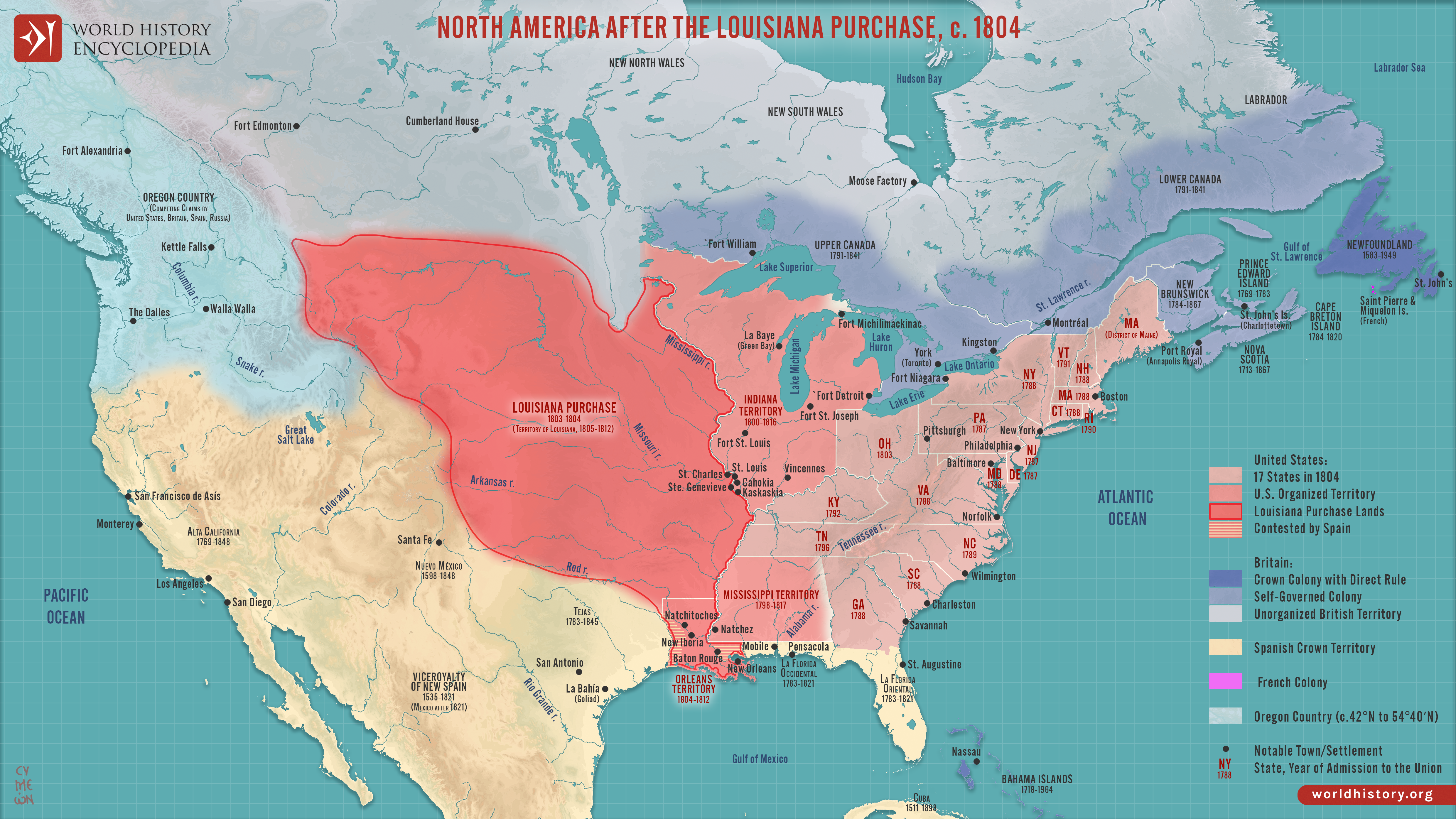
This map illustrates the geo-political situation in North America after The [Louisiana Purchase](https://www.worldhistory.org/Louisiana_Purchase/) - the 1803 acquisition by the United States of 828,000 square miles (2,144,000 square km) of French territory west of the Mississippi River. By doubling the size of the United States, The Louisiana Purchase set the stage for aggressive westward expansion and transformed the nation’s economic and political landscape. It allowed the U.S. to control the Mississippi River and the port of New Orleans, crucial for [trade](https://www.worldhistory.org/disambiguation/trade/) and [agriculture](https://www.worldhistory.org/disambiguation/Agriculture/). The acquisition also spurred the notion of *Manifest Destiny*, the belief that Americans were destined to settle across the continent, which justified expansion and conflict with Indigenous nations.
The Purchase pressured Spain’s hold on its North American territories and intensified rivalry with [Britain](https://www.worldhistory.org/disambiguation/Britain/) over the Oregon Country. Additionally, the vast new lands escalated the contentious debate over slavery as new states and territories were formed, eventually deepening the sectional divide that culminated in the Civil [War](https://www.worldhistory.org/disambiguation/War/).
#### Editorial Review
This human-authored image has been reviewed by our editorial team before publication to ensure accuracy, reliability and adherence to academic standards in accordance with our [editorial policy](https://www.worldhistory.org/static/editorial-policy/).
## About the Author
Simeon is a freelance visual designer and history educator, passionate about the human stories that shape the past.
- [Linkedin Profile](https://www.linkedin.com/in/simeon-netchev/)
## Cite This Work
### APA
Netchev, S. (2024, October 30). Map of the Louisiana Purchase. *World History Encyclopedia*.
### Chicago
Netchev, Simeon. "Map of the Louisiana Purchase." *World History Encyclopedia*, October 30, 2024. .
### MLA
Netchev, Simeon. "Map of the Louisiana Purchase." *World History Encyclopedia*, 30 Oct 2024, .
## License & Copyright
Submitted by [Simeon Netchev](https://www.worldhistory.org/user/simeonnetchev/ "User Page: Simeon Netchev"), published on 30 October 2024. The copyright holder has published this content under the following license: [Creative Commons Attribution-NonCommercial-NoDerivs](https://creativecommons.org/licenses/by-nc/4.0deed.en). This licence only allows others to download this content and share it with others as long as the author is credited, but they can't change the content in any way or use it commercially. When republishing on the web a hyperlink back to the original content source URL must be included. Please note that content linked from this page may have different licensing terms.