---
title: Map of the Sultanate of Rum & Anatolia, c. 1200: From Manzikert to Köse Dağ - Seljuk Expansion and Fall
author: Simeon Netchev
source: https://www.worldhistory.org/image/19415/map-of-the-sultanate-of-rum--anatolia-c-1200/
format: machine-readable-alternate
license: Creative Commons Attribution-NonCommercial-NoDerivs (https://creativecommons.org/licenses/by-nc/4.0)
updated: 2026-08-21
---
# Map of the Sultanate of Rum & Anatolia, c. 1200: From Manzikert to Köse Dağ - Seljuk Expansion and Fall
_Authored by [Simeon Netchev](https://www.worldhistory.org/user/simeonnetchev/)_
## Image File
[](https://www.worldhistory.org/uploads/images/19415.png)
## Image Caption
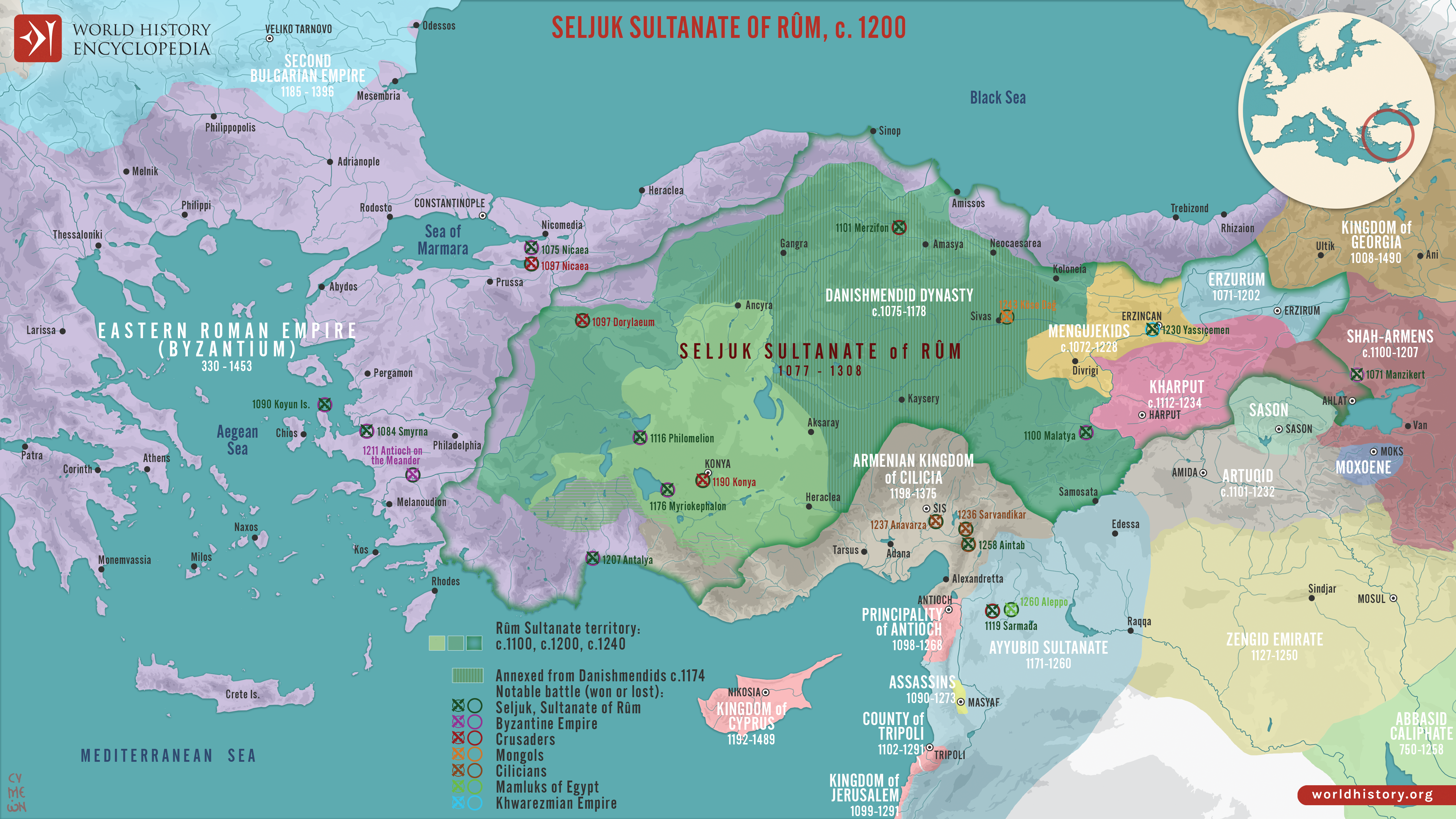
The Seljuk Sultanate of Rum (1077–1308) emerged amid the political fragmentation of [Anatolia](https://www.worldhistory.org/Asia_Minor/) following the Great Seljuk victory over the [Byzantine Empire](https://www.worldhistory.org/Byzantine_Empire/) at the [Battle of Manzikert](https://www.worldhistory.org/article/1189/battle-of-manzikert/) (1071), which accelerated Turkic migration, settlement, and military expansion across the region. The name *Rum*, derived from “Rome,” reflected Seljuk rule over territories long associated with the medieval [Eastern Roman Empire](https://www.worldhistory.org/Byzantine_Empire/). Established by the Seljuk prince Süleyman ibn Qutalmış (reign 1077–1086), the sultanate was first centred on Nicaea before shifting inland to Konya following the [First Crusade](https://www.worldhistory.org/First_Crusade/) (1096–1099). Over time, Persian administrative traditions, Turkic military elites, Islamic institutions, and the diverse Christian communities of Anatolia contributed to a complex political and cultural society.
During the 12th and early 13th centuries, Rum consolidated much of central Anatolia and expanded toward the [Mediterranean](https://www.worldhistory.org/disambiguation/mediterranean/) and Black Sea, while competing with Byzantines, Armenian [Cilicia](https://www.worldhistory.org/Cilicia/), neighbouring Turkish dynasties, [Crusader states](https://www.worldhistory.org/Crusader_States/), and other regional powers. Under Kaykhusraw I (reign 1192–1196; 1205–1211) and especially Kayqubad I (reign 1220–1237), expanding [trade](https://www.worldhistory.org/disambiguation/trade/) networks, urban development, caravanserais, and monumental [architecture](https://www.worldhistory.org/disambiguation/architecture/) reflected growing prosperity and political influence. This expansion was reversed after the [Mongol](https://www.worldhistory.org/Mongol_Empire/) victory at Köse Dağ (1243), which placed Rum under Mongol supremacy. During the later 13th century, declining central authority encouraged the rise of competing Anatolian beyliks, including the Ottomans, while the Sultanate of Rum finally disappeared in 1308.
#### Editorial Review
This human-authored image has been reviewed by our editorial team before publication to ensure accuracy, reliability and adherence to academic standards in accordance with our [editorial policy](https://www.worldhistory.org/static/editorial-policy/).
## About the Author
Simeon is a freelance visual designer and history educator, passionate about the human stories that shape the past.
- [Linkedin Profile](https://www.linkedin.com/in/simeon-netchev/)
## External Links
- [Raiders and Neighbours: The Turks (1040–1304) (Chapter 19)](https://www.cambridge.org/core/books/abs/cambridge-history-of-the-byzantine-empire-c5001492/raiders-and-neighbours-the-turks-10401304/8EBD7B875A29FE109BBB14E6796E302C)
## Cite This Work
### APA
Netchev, S. (2026, August 21). Map of the Sultanate of Rum & Anatolia, c. 1200: From Manzikert to Köse Dağ - Seljuk Expansion and Fall. *World History Encyclopedia*.
### Chicago
Netchev, Simeon. "Map of the Sultanate of Rum & Anatolia, c. 1200: From Manzikert to Köse Dağ - Seljuk Expansion and Fall." *World History Encyclopedia*, August 21, 2026. .
### MLA
Netchev, Simeon. "Map of the Sultanate of Rum & Anatolia, c. 1200: From Manzikert to Köse Dağ - Seljuk Expansion and Fall." *World History Encyclopedia*, 21 Aug 2026, .
## License & Copyright
Submitted by [Simeon Netchev](https://www.worldhistory.org/user/simeonnetchev/ "User Page: Simeon Netchev"), published on 21 August 2026. The copyright holder has published this content under the following license: [Creative Commons Attribution-NonCommercial-NoDerivs](https://creativecommons.org/licenses/by-nc/4.0deed.en). This licence only allows others to download this content and share it with others as long as the author is credited, but they can't change the content in any way or use it commercially. When republishing on the web a hyperlink back to the original content source URL must be included. Please note that content linked from this page may have different licensing terms.