---
title: Map of The D-Day and the Normandy Landings, June 1944: Operation Overlord & History's Largest Amphibious Invasion
author: Simeon Netchev
source: https://www.worldhistory.org/image/18983/map-of-the-d-day-and-the-normandy-landings-june-19/
format: machine-readable-alternate
license: Creative Commons Attribution-NonCommercial-NoDerivs (https://creativecommons.org/licenses/by-nc/4.0)
updated: 2026-06-08
---
# Map of The D-Day and the Normandy Landings, June 1944: Operation Overlord & History's Largest Amphibious Invasion
_Authored by [Simeon Netchev](https://www.worldhistory.org/user/simeonnetchev/)_
## Image File
[](https://www.worldhistory.org/uploads/images/18983.png)
## Image Caption
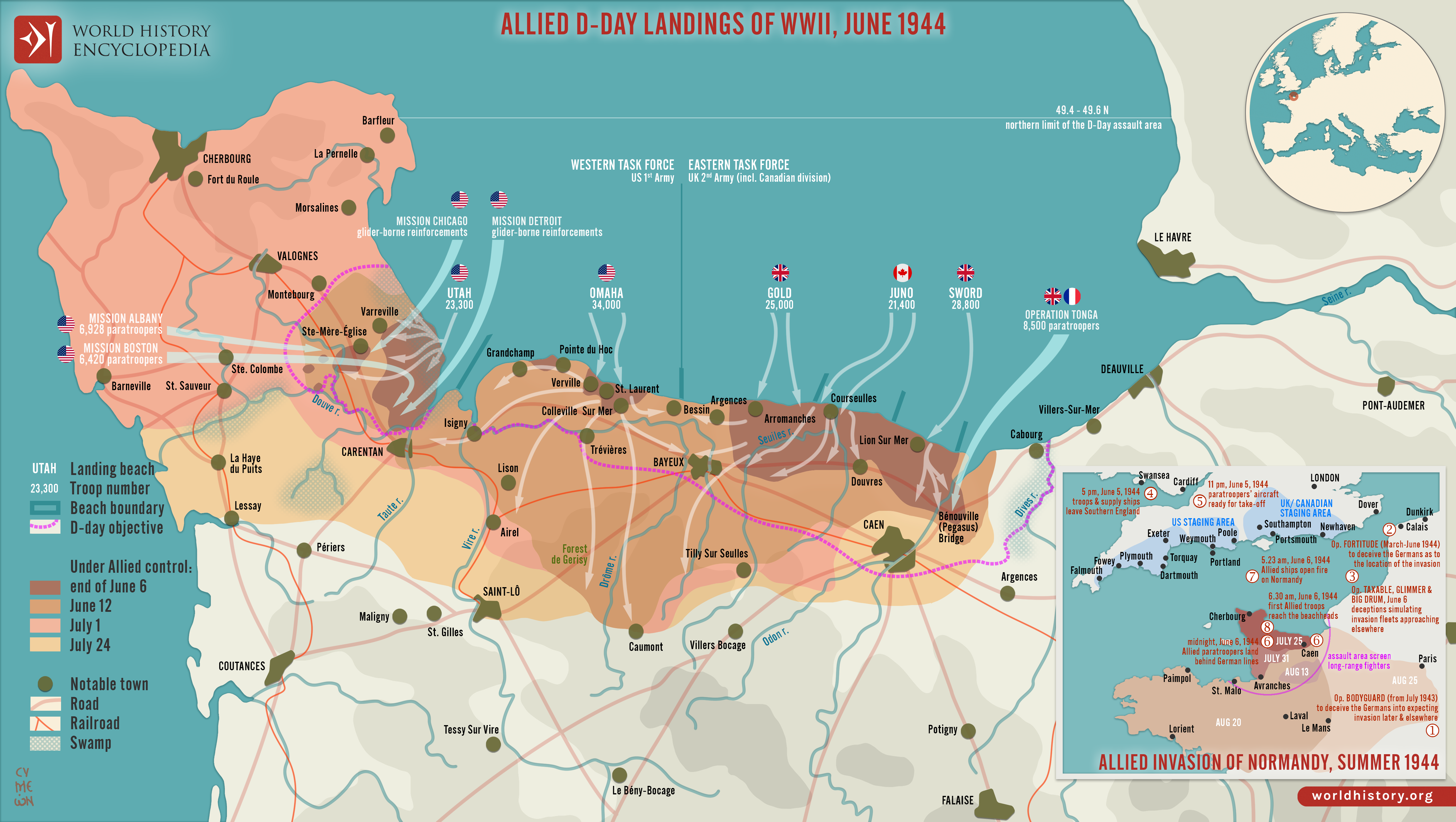
The Allied landings in Normandy on 6 June 1944, commonly known as [D-Day](https://www.worldhistory.org/D-Day/), marked one of the most significant operations of the Second World [War](https://www.worldhistory.org/disambiguation/War/) (1939-1945) and the largest amphibious invasion in military history. As the opening phase of Operation Overlord, the invasion sought to establish a permanent Allied foothold in German-occupied Western [Europe](https://www.worldhistory.org/europe/) and create the conditions for the liberation of France. Forces from the United States, United Kingdom, Canada, and numerous Allied nations crossed the English Channel and assaulted five designated landing beaches, Utah, Omaha, [Gold](https://www.worldhistory.org/gold/), [Juno](https://www.worldhistory.org/Juno/), and Sword, supported by extensive naval, airborne, and air operations. The success of the landings reflected years of planning, logistical preparation, intelligence gathering, and multinational coordination.
Despite strong resistance from German forces under [Adolf Hitler](https://www.worldhistory.org/Adolf_Hitler/) (rule 1933-1945) and the extensive fortifications of the Atlantic [Wall](https://www.worldhistory.org/wall/), Allied troops secured critical beachheads and gradually expanded their position in Normandy. The campaign that followed culminated in the liberation of [Paris](https://www.worldhistory.org/disambiguation/paris/) in August 1944 and opened a major Western Front against Nazi Germany. D-Day did not end the war, but it fundamentally altered the strategic balance in Europe by forcing Germany to fight a sustained two-front conflict. As a result, the [Normandy landings](https://www.worldhistory.org/collection/243/the-normandy-landings/) are widely regarded as a decisive turning point in the defeat of Nazi Germany and the liberation of Western Europe.
#### Editorial Review
This human-authored image has been reviewed by our editorial team before publication to ensure accuracy, reliability and adherence to academic standards in accordance with our [editorial policy](https://www.worldhistory.org/static/editorial-policy/).
## About the Author
Simeon is a freelance visual designer and history educator, passionate about the human stories that shape the past.
- [Linkedin Profile](https://www.linkedin.com/in/simeon-netchev/)
## External Links
- [10 Things You Need to Know about D-Day - IWM](https://www.iwm.org.uk/history/the-10-things-you-need-to-know-about-d-day)
- [World War II: D-Day, The Invasion of Normandy](https://www.eisenhowerlibrary.gov/research/online-documents/world-war-ii-d-day-invasion-normandy)
- [D-Day (June 6, 1944) | World War II (1941-1945) | Serving: Our Voices | Veterans History Project Collection | Digital Collections | Library of Congress](https://www.loc.gov/collections/veterans-history-project-collection/serving-our-voices/world-war-ii/d-day-june-6-1944/)
## Cite This Work
### APA
Netchev, S. (2024, May 22). Map of The D-Day and the Normandy Landings, June 1944: Operation Overlord & History's Largest Amphibious Invasion. *World History Encyclopedia*.
### Chicago
Netchev, Simeon. "Map of The D-Day and the Normandy Landings, June 1944: Operation Overlord & History's Largest Amphibious Invasion." *World History Encyclopedia*, May 22, 2024. .
### MLA
Netchev, Simeon. "Map of The D-Day and the Normandy Landings, June 1944: Operation Overlord & History's Largest Amphibious Invasion." *World History Encyclopedia*, 22 May 2024, .
## License & Copyright
Submitted by [Simeon Netchev](https://www.worldhistory.org/user/simeonnetchev/ "User Page: Simeon Netchev"), published on 22 May 2024. The copyright holder has published this content under the following license: [Creative Commons Attribution-NonCommercial-NoDerivs](https://creativecommons.org/licenses/by-nc/4.0deed.en). This licence only allows others to download this content and share it with others as long as the author is credited, but they can't change the content in any way or use it commercially. When republishing on the web a hyperlink back to the original content source URL must be included. Please note that content linked from this page may have different licensing terms.