---
title: Map of Ibn Battuta’s Travels, 1325-1354: Medieval Travel, Scholarship & Connectivity in Afro-Eurasia
author: Simeon Netchev
source: https://www.worldhistory.org/image/18929/map-of-ibn-battutas-travels-1325-1354/
format: machine-readable-alternate
license: Creative Commons Attribution-NonCommercial-NoDerivs (https://creativecommons.org/licenses/by-nc/4.0)
updated: 2026-05-08
---
# Map of Ibn Battuta’s Travels, 1325-1354: Medieval Travel, Scholarship & Connectivity in Afro-Eurasia
_Authored by [Simeon Netchev](https://www.worldhistory.org/user/simeonnetchev/)_
## Image File
[](https://www.worldhistory.org/uploads/images/18929.png)
## Image Caption
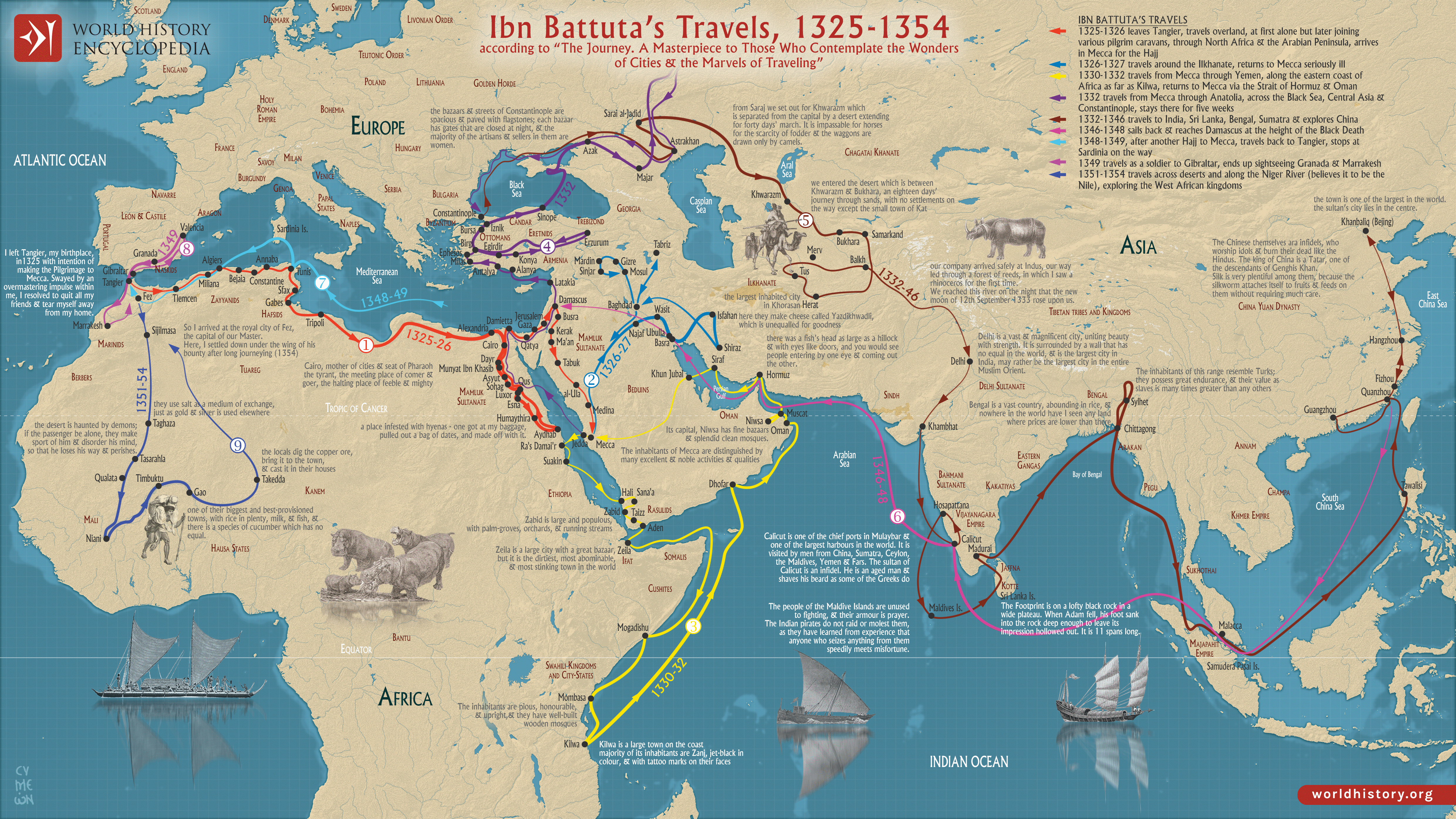
[Ibn Battuta](https://www.worldhistory.org/Ibn_Battuta/) ((Abū Abd Allāh Muḥammad ibn Abd Allāh Al-Lawātī, 1304–c. 1368 CE) was a traveler, jurist, and scholar from Tangier whose journeys across Afro-Eurasia remain among the most extensive recorded in the medieval world. Beginning in 1325 with a pilgrimage to Mecca, his travels eventually spanned North and West [Africa](https://www.worldhistory.org/disambiguation/africa/), [Egypt](https://www.worldhistory.org/egypt/), [Syria](https://www.worldhistory.org/syria/), East Africa, [Persia](https://www.worldhistory.org/Persia/), Central Asia, [India](https://www.worldhistory.org/india/), Southeast Asia, and [China](https://www.worldhistory.org/china/), covering an estimated 120,000 kilometers (75,000 miles) over nearly three decades. His experiences reflected the high degree of connectivity that linked much of the Islamic world during the post-[Mongol](https://www.worldhistory.org/Mongol_Empire/) era, where shared religious institutions, [trade](https://www.worldhistory.org/disambiguation/trade/) routes, and scholarly networks facilitated movement across vast distances within the broader framework of Dar al-[Islam](https://www.worldhistory.org/islam/) (*“the Abode of Islam”*).
After returning to the Marinid Sultanate in the 1350s, Ibn Battuta dictated his experiences to the scholar Ibn Juzayy, producing the *Rihla* (“The Journey”), one of the most important travel accounts of the medieval period. The work documents political systems, urban life, trade, religious practice, and cultural diversity across regions ranging from the [Mali Empire](https://www.worldhistory.org/Mali_Empire/) and the Delhi Sultanate to Yuan China. Although parts of the narrative likely contain embellishment or second-hand material, the Rihla remains an invaluable primary source for understanding the interconnected commercial, intellectual, and political worlds of the 14th century.
#### Editorial Review
This human-authored image has been reviewed by our editorial team before publication to ensure accuracy, reliability and adherence to academic standards in accordance with our [editorial policy](https://www.worldhistory.org/static/editorial-policy/).
## About the Author
Simeon is a freelance visual designer and history educator, passionate about the human stories that shape the past.
- [Linkedin Profile](https://www.linkedin.com/in/simeon-netchev/)
## External Links
- [Ibn Battuta Travels In Asia And Africa 1325-1354 ](https://archive.org/details/in.ernet.dli.2015.62617/page/n1/mode/2up)
- [Medieval Trade Routes Map](https://easyzoom.com/image/218139)
## Cite This Work
### APA
Netchev, S. (2026, May 08). Map of Ibn Battuta’s Travels, 1325-1354: Medieval Travel, Scholarship & Connectivity in Afro-Eurasia. *World History Encyclopedia*.
### Chicago
Netchev, Simeon. "Map of Ibn Battuta’s Travels, 1325-1354: Medieval Travel, Scholarship & Connectivity in Afro-Eurasia." *World History Encyclopedia*, May 08, 2026. .
### MLA
Netchev, Simeon. "Map of Ibn Battuta’s Travels, 1325-1354: Medieval Travel, Scholarship & Connectivity in Afro-Eurasia." *World History Encyclopedia*, 08 May 2026, .
## License & Copyright
Submitted by [Simeon Netchev](https://www.worldhistory.org/user/simeonnetchev/ "User Page: Simeon Netchev"), published on 08 May 2026. The copyright holder has published this content under the following license: [Creative Commons Attribution-NonCommercial-NoDerivs](https://creativecommons.org/licenses/by-nc/4.0deed.en). This licence only allows others to download this content and share it with others as long as the author is credited, but they can't change the content in any way or use it commercially. When republishing on the web a hyperlink back to the original content source URL must be included. Please note that content linked from this page may have different licensing terms.