---
title: Map of a Circumnavigation of the Black Sea c. 130 CE: Arrian of Nicomedia's "Periplus Ponti Euxini"
author: Simeon Netchev
source: https://www.worldhistory.org/image/18252/map-of-a-circumnavigation-of-the-black-sea-c-130-c/
format: machine-readable-alternate
license: Creative Commons Attribution-NonCommercial-NoDerivs (https://creativecommons.org/licenses/by-nc/4.0)
updated: 2025-10-17
---
# Map of a Circumnavigation of the Black Sea c. 130 CE: Arrian of Nicomedia's "Periplus Ponti Euxini"
_Authored by [Simeon Netchev](https://www.worldhistory.org/user/simeonnetchev/)_
## Image File
[](https://www.worldhistory.org/uploads/images/18252.png)
## Image Caption
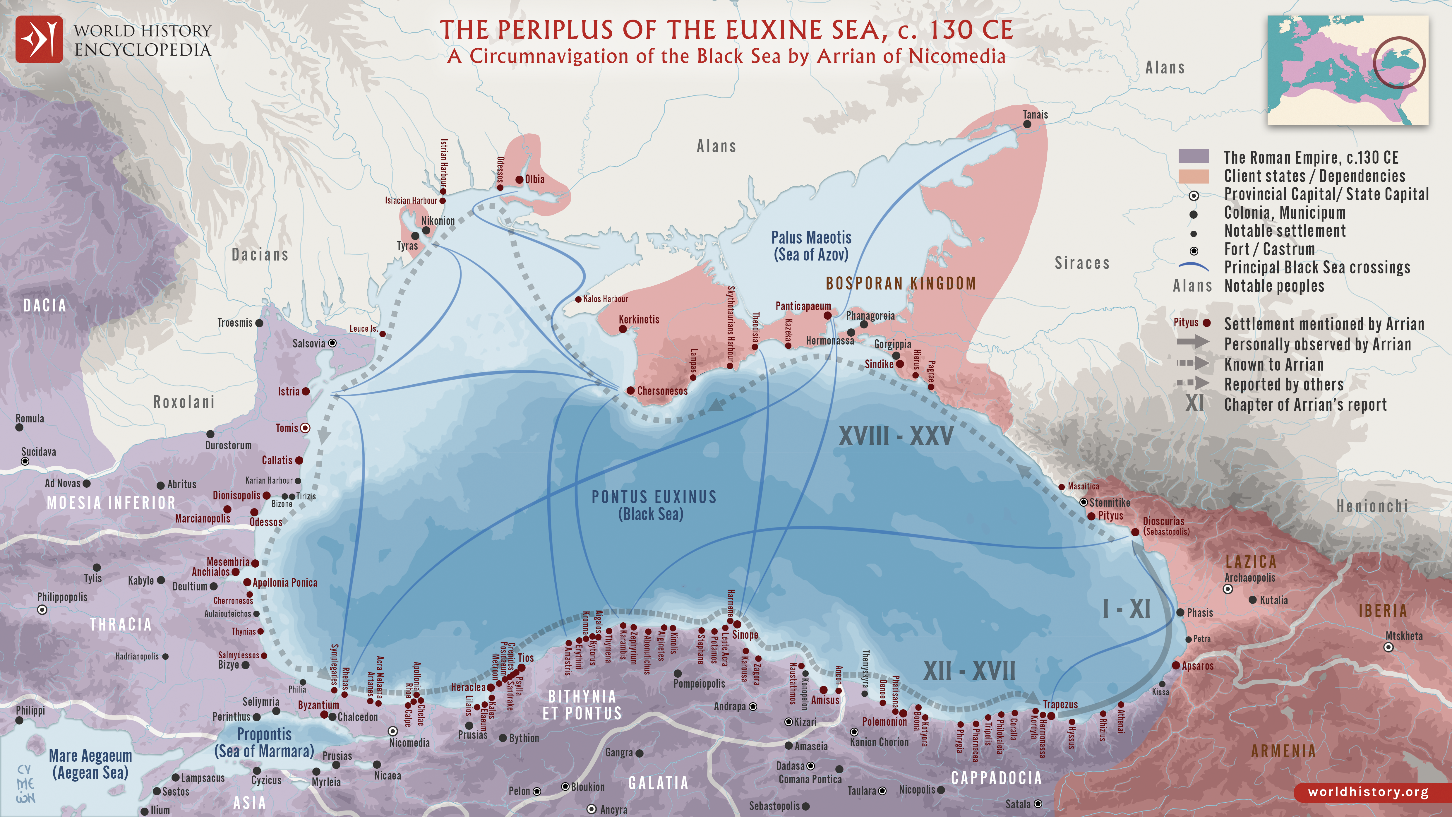
*The Periplus Ponti Euxini* (“Circumnavigation of the Black Sea”) by [Arrian](https://www.worldhistory.org/Arrian/) of Nicomedia (c. 86–after 146 CE) is a remarkable example of [Roman](https://www.worldhistory.org/disambiguation/Roman/) geographical and administrative [writing](https://www.worldhistory.org/writing/) from the early 2nd century CE. The term Periplus, derived from the [Greek](https://www.worldhistory.org/disambiguation/greek/) periplous (“a sailing-around”), refers to a navigational text describing a coastal voyage. Written around 130 CE, the work takes the form of a letter from Arrian, then Governor of Cappadocia under Emperor [Hadrian](https://www.worldhistory.org/hadrian/) (reign 117–138 CE), to the emperor himself. Arrian details his journey around the Black Sea, combining practical maritime descriptions with political and strategic observations - an account that mirrors Hadrian’s broader interest in consolidating and understanding the [empire](https://www.worldhistory.org/empire/)’s frontiers.
The text serves both as a navigational manual and as a document of imperial governance, listing ports, harbors, and coastal landmarks while recording the distances and conditions faced by sailors. Beyond its technical value, the Periplus offers insight into Roman control and economic integration of the Black Sea region, highlighting its role as a hub for [trade](https://www.worldhistory.org/disambiguation/trade/) between the [Mediterranean](https://www.worldhistory.org/disambiguation/mediterranean/) and Eurasian interiors. It reflects the Roman worldview of exploration, order, and connectivity, illustrating how geography, administration, and imperial ideology intertwined during Hadrian’s reign.
#### Editorial Review
This human-authored image has been reviewed by our editorial team before publication to ensure accuracy, reliability and adherence to academic standards in accordance with our [editorial policy](https://www.worldhistory.org/static/editorial-policy/).
## About the Author
Simeon is a freelance visual designer and history educator, passionate about the human stories that shape the past.
- [Linkedin Profile](https://www.linkedin.com/in/simeon-netchev/)
## Cite This Work
### APA
Netchev, S. (2023, December 12). Map of a Circumnavigation of the Black Sea c. 130 CE: Arrian of Nicomedia's "Periplus Ponti Euxini". *World History Encyclopedia*.
### Chicago
Netchev, Simeon. "Map of a Circumnavigation of the Black Sea c. 130 CE: Arrian of Nicomedia's "Periplus Ponti Euxini"." *World History Encyclopedia*, December 12, 2023. .
### MLA
Netchev, Simeon. "Map of a Circumnavigation of the Black Sea c. 130 CE: Arrian of Nicomedia's "Periplus Ponti Euxini"." *World History Encyclopedia*, 12 Dec 2023, .
## License & Copyright
Submitted by [Simeon Netchev](https://www.worldhistory.org/user/simeonnetchev/ "User Page: Simeon Netchev"), published on 12 December 2023. The copyright holder has published this content under the following license: [Creative Commons Attribution-NonCommercial-NoDerivs](https://creativecommons.org/licenses/by-nc/4.0deed.en). This licence only allows others to download this content and share it with others as long as the author is credited, but they can't change the content in any way or use it commercially. When republishing on the web a hyperlink back to the original content source URL must be included. Please note that content linked from this page may have different licensing terms.