---
title: Map of Settlement & Mobility in the Aegean, c. 1100-550 BCE: Migration, Memory, and the Making of the Greek World
author: Simeon Netchev
source: https://www.worldhistory.org/image/17921/map-of-settlement--mobility-in-the-aegean-c-1100-5/
format: machine-readable-alternate
license: Creative Commons Attribution-NonCommercial-NoDerivs (https://creativecommons.org/licenses/by-nc/4.0)
updated: 2026-03-04
---
# Map of Settlement & Mobility in the Aegean, c. 1100-550 BCE: Migration, Memory, and the Making of the Greek World
_Authored by [Simeon Netchev](https://www.worldhistory.org/user/simeonnetchev/)_
## Image File
[](https://www.worldhistory.org/uploads/images/17921.png)
## Image Caption
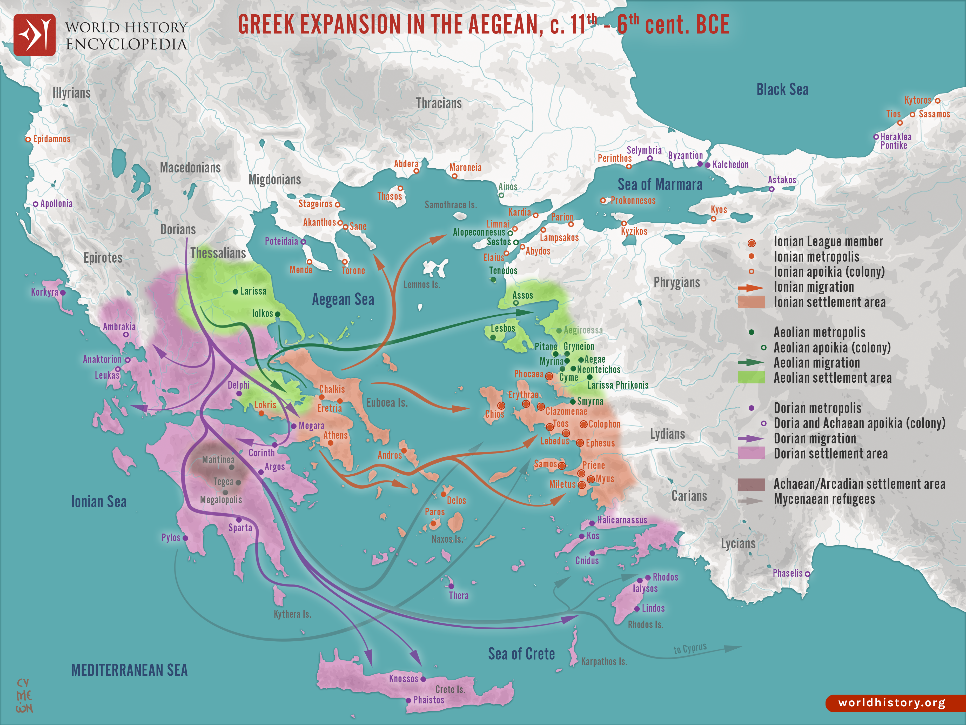
The period following the collapse of the [Mycenaean](https://www.worldhistory.org/Mycenaean_Civilization/) palatial system (c. 1200–1100 BCE) saw profound demographic and cultural reorganization across the [Aegean](https://www.worldhistory.org/aegean/). During the so-called [Greek](https://www.worldhistory.org/disambiguation/greek/) “Dark Age” (c. 1100–800 BCE), communities fragmented into smaller settlements while populations gradually redistributed across mainland [Greece](https://www.worldhistory.org/greece/), the Aegean islands, and the western coast of [Anatolia](https://www.worldhistory.org/Asia_Minor/). Ancient Greek traditions later described these movements as migrations of distinct tribal groups, Aeolian, Ionian, Doric, and Achaean/Arcadian, although modern scholarship generally interprets them as complex processes of mobility, resettlement, and cultural transformation rather than single invasion events. In regions such as Aeolis, [Ionia](https://www.worldhistory.org/ionia/), and the Dodecanese, emerging communities preserved elements of earlier Mycenaean heritage while adapting to new political and economic realities.
By the early [Archaic period](https://www.worldhistory.org/Archaic_Period/) (c. 800–550 BCE), these networks of settlements formed the foundation of a revitalized Greek world organized around the Aegean Sea and western Anatolia. Communities such as Miletus, [Ephesus](https://www.worldhistory.org/ephesos/), and Smyrna became important hubs of [trade](https://www.worldhistory.org/disambiguation/trade/), craftsmanship, and intellectual exchange. These developments coincided with the emergence of the Greek [polis](https://www.worldhistory.org/Polis/) ([city-state](https://www.worldhistory.org/Polis/)), the revival of [writing](https://www.worldhistory.org/writing/) through the adoption of the [alphabet](https://www.worldhistory.org/alphabet/) (c. 8th century BCE), and expanding maritime connections throughout the [Mediterranean](https://www.worldhistory.org/disambiguation/mediterranean/). Thus, the centuries of mobility and resettlement after the Mycenaean collapse ultimately produced a more interconnected Aegean world, setting the stage for the political, economic, and cultural dynamism of [Archaic](https://www.worldhistory.org/disambiguation/Archaic/) Greece.
#### Editorial Review
This human-authored image has been reviewed by our editorial team before publication to ensure accuracy, reliability and adherence to academic standards in accordance with our [editorial policy](https://www.worldhistory.org/static/editorial-policy/).
## About the Author
Simeon is a freelance visual designer and history educator, passionate about the human stories that shape the past.
- [Linkedin Profile](https://www.linkedin.com/in/simeon-netchev/)
## Cite This Work
### APA
Netchev, S. (2026, March 04). Map of Settlement & Mobility in the Aegean, c. 1100-550 BCE: Migration, Memory, and the Making of the Greek World. *World History Encyclopedia*.
### Chicago
Netchev, Simeon. "Map of Settlement & Mobility in the Aegean, c. 1100-550 BCE: Migration, Memory, and the Making of the Greek World." *World History Encyclopedia*, March 04, 2026. .
### MLA
Netchev, Simeon. "Map of Settlement & Mobility in the Aegean, c. 1100-550 BCE: Migration, Memory, and the Making of the Greek World." *World History Encyclopedia*, 04 Mar 2026, .
## License & Copyright
Submitted by [Simeon Netchev](https://www.worldhistory.org/user/simeonnetchev/ "User Page: Simeon Netchev"), published on 04 March 2026. The copyright holder has published this content under the following license: [Creative Commons Attribution-NonCommercial-NoDerivs](https://creativecommons.org/licenses/by-nc/4.0deed.en). This licence only allows others to download this content and share it with others as long as the author is credited, but they can't change the content in any way or use it commercially. When republishing on the web a hyperlink back to the original content source URL must be included. Please note that content linked from this page may have different licensing terms.