---
title: Map of the The Roman Empire under the Flavian Dynasty, c. 96: Provinces, Frontiers, and Expansion after 69 CE
author: Simeon Netchev
source: https://www.worldhistory.org/image/17609/map-of-the-the-roman-empire-under-the-flavian-dyna/
format: machine-readable-alternate
license: Creative Commons Attribution-NonCommercial-NoDerivs (https://creativecommons.org/licenses/by-nc/4.0)
updated: 2026-10-02
---
# Map of the The Roman Empire under the Flavian Dynasty, c. 96: Provinces, Frontiers, and Expansion after 69 CE
_Authored by [Simeon Netchev](https://www.worldhistory.org/user/simeonnetchev/)_
## Image File
[](https://www.worldhistory.org/uploads/images/17609.png)
## Image Caption
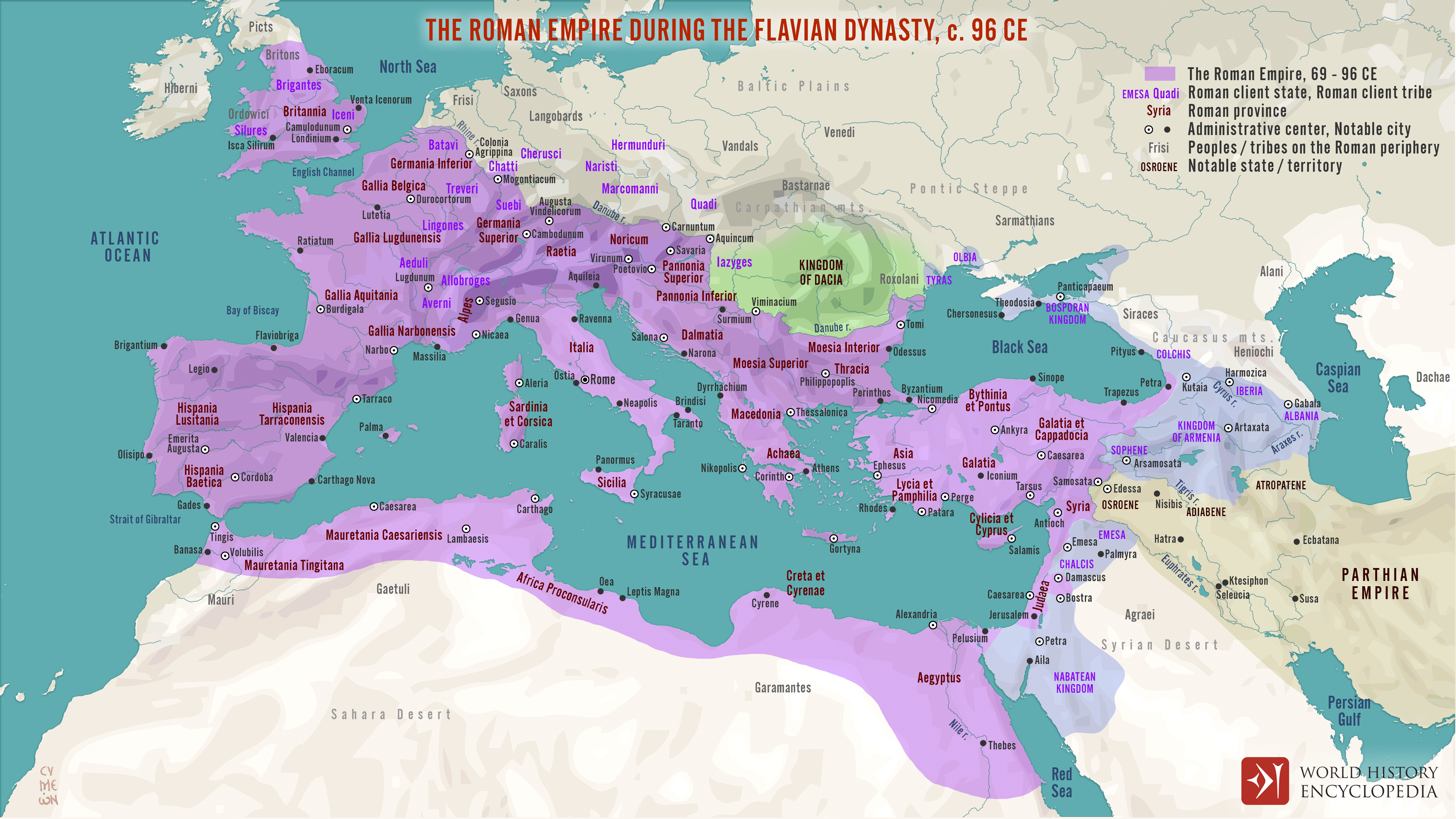
The [Roman Empire](https://www.worldhistory.org/Roman_Empire/) at the close of the Flavian dynasty (69–96 CE) reflected a period of political recovery and administrative consolidation following the [Year of the Four Emperors](https://www.worldhistory.org/Year_of_the_Four_Emperors/). [Vespasian](https://www.worldhistory.org/Vespasian/) (r. 69–79 CE) founded a new imperial house, followed by [Titus](https://www.worldhistory.org/disambiguation/Titus/) (reign 79–81 CE) and [Domitian](https://www.worldhistory.org/domitian/) (reign 81–96 CE). The Flavians strengthened provincial government, expanded imperial administration, reinforced the army and frontier system, and incorporated several territories more firmly into [Roman](https://www.worldhistory.org/disambiguation/Roman/) rule. Their reigns demonstrate how emperors used military power, provincial administration, and monumental building to restore authority after civil conflict.
By 96 CE, Roman power extended from [Britain](https://www.worldhistory.org/disambiguation/Britain/) and the Rhine–Danube frontier to North [Africa](https://www.worldhistory.org/disambiguation/africa/), [Syria](https://www.worldhistory.org/syria/), and the Euphrates. The First Jewish–Roman [War](https://www.worldhistory.org/disambiguation/War/) ended with [Jerusalem](https://www.worldhistory.org/jerusalem/)'s capture in 70 CE; Agricola campaigned deep into northern Britain; Roman control expanded through the Agri Decumates; and Domitian's wars with [Dacia](https://www.worldhistory.org/dacia/) made the Danube a major strategic theater. In the East, [Rome](https://www.worldhistory.org/Rome/) confronted Parthian influence through fortified provinces and allied kingdoms such as [Armenia](https://www.worldhistory.org/armenia/). These developments strengthened the [empire](https://www.worldhistory.org/empire/) while leaving frontier challenges that would shape Roman policy under [Trajan](https://www.worldhistory.org/trajan/) and his successors.
#### Editorial Review
This human-authored image has been reviewed by our editorial team before publication to ensure accuracy, reliability and adherence to academic standards in accordance with our [editorial policy](https://www.worldhistory.org/static/editorial-policy/).
## About the Author
Simeon is a freelance visual designer and history educator, passionate about the human stories that shape the past.
- [Linkedin Profile](https://www.linkedin.com/in/simeon-netchev/)
## Cite This Work
### APA
Netchev, S. (2026, October 02). Map of the The Roman Empire under the Flavian Dynasty, c. 96: Provinces, Frontiers, and Expansion after 69 CE. *World History Encyclopedia*.
### Chicago
Netchev, Simeon. "Map of the The Roman Empire under the Flavian Dynasty, c. 96: Provinces, Frontiers, and Expansion after 69 CE." *World History Encyclopedia*, October 02, 2026. .
### MLA
Netchev, Simeon. "Map of the The Roman Empire under the Flavian Dynasty, c. 96: Provinces, Frontiers, and Expansion after 69 CE." *World History Encyclopedia*, 02 Oct 2026, .
## License & Copyright
Submitted by [Simeon Netchev](https://www.worldhistory.org/user/simeonnetchev/ "User Page: Simeon Netchev"), published on 02 October 2026. The copyright holder has published this content under the following license: [Creative Commons Attribution-NonCommercial-NoDerivs](https://creativecommons.org/licenses/by-nc/4.0deed.en). This licence only allows others to download this content and share it with others as long as the author is credited, but they can't change the content in any way or use it commercially. When republishing on the web a hyperlink back to the original content source URL must be included. Please note that content linked from this page may have different licensing terms.