---
title: Map of the Roman Rule in Britain c. 43 - 410 CE: Four Centuries of Empire at the Edge of the World
author: Simeon Netchev
source: https://www.worldhistory.org/image/17564/map-of-the-roman-rule-in-britain-c-43---410-ce/
format: machine-readable-alternate
license: Creative Commons Attribution-NonCommercial-NoDerivs (https://creativecommons.org/licenses/by-nc/4.0)
updated: 2025-11-17
---
# Map of the Roman Rule in Britain c. 43 - 410 CE: Four Centuries of Empire at the Edge of the World
_Authored by [Simeon Netchev](https://www.worldhistory.org/user/simeonnetchev/)_
## Image File
[](https://www.worldhistory.org/uploads/images/17564.png)
## Image Caption
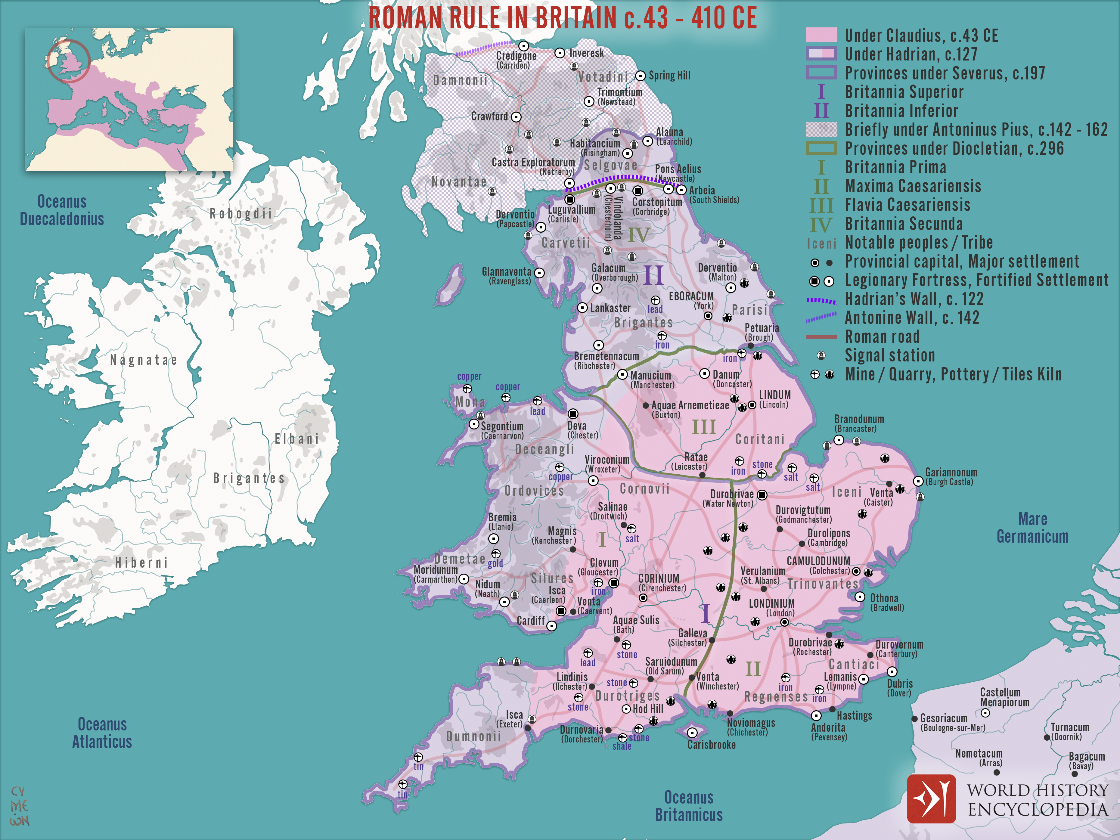
[Roman](https://www.worldhistory.org/disambiguation/Roman/) rule in [Britain](https://www.worldhistory.org/disambiguation/Britain/) developed between 43 and 410 CE, reshaping the island from a [mosaic](https://www.worldhistory.org/Mosaic/) of tribal societies into a province integrated into the political, economic, and cultural structures of the [Roman Empire](https://www.worldhistory.org/Roman_Empire/). Although [Julius Caesar](https://www.worldhistory.org/Julius_Caesar/)’s expeditions (55–54 BCE) first established contact, sustained [conquest](https://www.worldhistory.org/warfare/) began only under Emperor [Claudius](https://www.worldhistory.org/claudius/) (reign 41–54 CE), whose legions invaded in 43 CE and gradually secured control of southeastern Britain. Roman administration introduced centralized governance, taxation, [coinage](https://www.worldhistory.org/coinage/), and urban planning, while an expanding network of roads, forts, baths, and towns connected [Britannia](https://www.worldhistory.org/Roman_Britain/) to wider imperial systems. These developments encouraged varying degrees of Romanization: many Britons adopted Latin, new fashions, and imported goods, though local identities and regional differences persisted.
Over nearly four centuries, the province remained a militarized frontier, shaped by both continuity and pressure. Successive emperors invested in defensive systems, most notably [Hadrian](https://www.worldhistory.org/hadrian/)’s [Wall](https://www.worldhistory.org/wall/), begun under Hadrian (reign 117–138 CE), to contain persistent threats from Caledonian and later Pictish groups. By the early 5th century, escalating crises across the [empire](https://www.worldhistory.org/empire/), including civil wars and external invasions, forced strategic retrenchment. In 410 CE, Emperor Honorius (reign 393–423 CE) instructed the [cities](https://www.worldhistory.org/city/) of Britain to organize their own defense, effectively ending imperial administration. Yet the withdrawal was not an abrupt rupture: many soldiers, settlers, and officials remained, and aspects of Roman governance and [culture](https://www.worldhistory.org/disambiguation/culture/) endured, shaping the slow and uneven transition into post-[Roman Britain](https://www.worldhistory.org/Roman_Britain/).
#### Editorial Review
This human-authored image has been reviewed by our editorial team before publication to ensure accuracy, reliability and adherence to academic standards in accordance with our [editorial policy](https://www.worldhistory.org/static/editorial-policy/).
## About the Author
Simeon is a freelance visual designer and history educator, passionate about the human stories that shape the past.
- [Linkedin Profile](https://www.linkedin.com/in/simeon-netchev/)
## Cite This Work
### APA
Netchev, S. (2023, June 21). Map of the Roman Rule in Britain c. 43 - 410 CE: Four Centuries of Empire at the Edge of the World. *World History Encyclopedia*.
### Chicago
Netchev, Simeon. "Map of the Roman Rule in Britain c. 43 - 410 CE: Four Centuries of Empire at the Edge of the World." *World History Encyclopedia*, June 21, 2023. .
### MLA
Netchev, Simeon. "Map of the Roman Rule in Britain c. 43 - 410 CE: Four Centuries of Empire at the Edge of the World." *World History Encyclopedia*, 21 Jun 2023, .
## License & Copyright
Submitted by [Simeon Netchev](https://www.worldhistory.org/user/simeonnetchev/ "User Page: Simeon Netchev"), published on 21 June 2023. The copyright holder has published this content under the following license: [Creative Commons Attribution-NonCommercial-NoDerivs](https://creativecommons.org/licenses/by-nc/4.0deed.en). This licence only allows others to download this content and share it with others as long as the author is credited, but they can't change the content in any way or use it commercially. When republishing on the web a hyperlink back to the original content source URL must be included. Please note that content linked from this page may have different licensing terms.