---
title: Map of the ancient Near East during the Amarna Period
author: Briangotts
source: https://www.worldhistory.org/image/171/map-of-the-ancient-near-east-during-the-amarna-per/
format: machine-readable-alternate
license: Creative Commons Attribution-ShareAlike (https://creativecommons.org/licenses/by-sa/4.0)
updated: 1970-01-01
---
# Map of the ancient Near East during the Amarna Period
_Authored by Briangotts_
## Image File
[](https://www.worldhistory.org/uploads/images/171.png)
## Image Caption
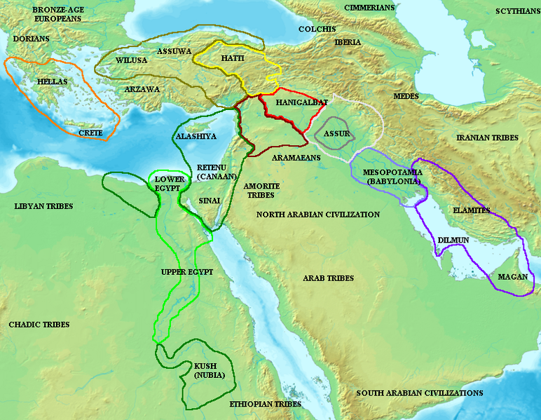
Map of the ancient [Near East](https://www.worldhistory.org/Near_East/) during the [Amarna Period](https://www.worldhistory.org/Amarna_Period_of_Egypt/), showing the great powers of the period: [Egypt](https://www.worldhistory.org/egypt/) (green), [Hatti](https://www.worldhistory.org/hatti/) (yellow), the [Kassite](https://www.worldhistory.org/kassite/) kingdom of [Babylon](https://www.worldhistory.org/babylon/) (purple), [Assyria](https://www.worldhistory.org/assyria/) (grey), and [Mittani](https://www.worldhistory.org/Mitanni/) (red). Lighter areas show direct control, darker areas represent spheres of influence. The extent of the Achaean/[Mycenaean civilization](https://www.worldhistory.org/Mycenaean_Civilization/) is shown in orange.
## Cite This Work
### APA
Briangotts. (2012, April 26). Map of the ancient Near East during the Amarna Period. *World History Encyclopedia*.
### Chicago
Briangotts. "Map of the ancient Near East during the Amarna Period." *World History Encyclopedia*, April 26, 2012. .
### MLA
Briangotts. "Map of the ancient Near East during the Amarna Period." *World History Encyclopedia*, 26 Apr 2012, .
## License & Copyright
[Original image](http://en.wikipedia.org/wiki/File:Amarnamap.png) by [**Briangotts**](http://en.wikipedia.org/wiki/File:Amarnamap.png). Submitted by [Jan van der Crabben](https://www.worldhistory.org/user/jvdc/ "User Page: Jan van der Crabben"), published on 26 April 2012. The copyright holder has published this content under the following license: [Creative Commons Attribution-ShareAlike](https://creativecommons.org/licenses/by-sa/4.0deed.en). This license lets others remix, tweak, and build upon a work even for commercial reasons, as long as they credit the author and license their new creations under the identical terms. When republishing on the web a hyperlink back to the original content source URL must be included. Please note that content linked from this page may have different licensing terms.