---
title: Map of the Parthian (Arsacid) Empire, c. 150 CE: Iran’s Cavalry Empire Between Rome and the Silk Roads
author: Simeon Netchev
source: https://www.worldhistory.org/image/16824/map-of-the-parthian-arsacid-empire-c-150-ce/
format: machine-readable-alternate
license: Creative Commons Attribution-NonCommercial-NoDerivs (https://creativecommons.org/licenses/by-nc/4.0)
updated: 2026-07-12
---
# Map of the Parthian (Arsacid) Empire, c. 150 CE: Iran’s Cavalry Empire Between Rome and the Silk Roads
_Authored by [Simeon Netchev](https://www.worldhistory.org/user/simeonnetchev/)_
## Image File
[](https://www.worldhistory.org/uploads/images/16824.png)
## Image Caption
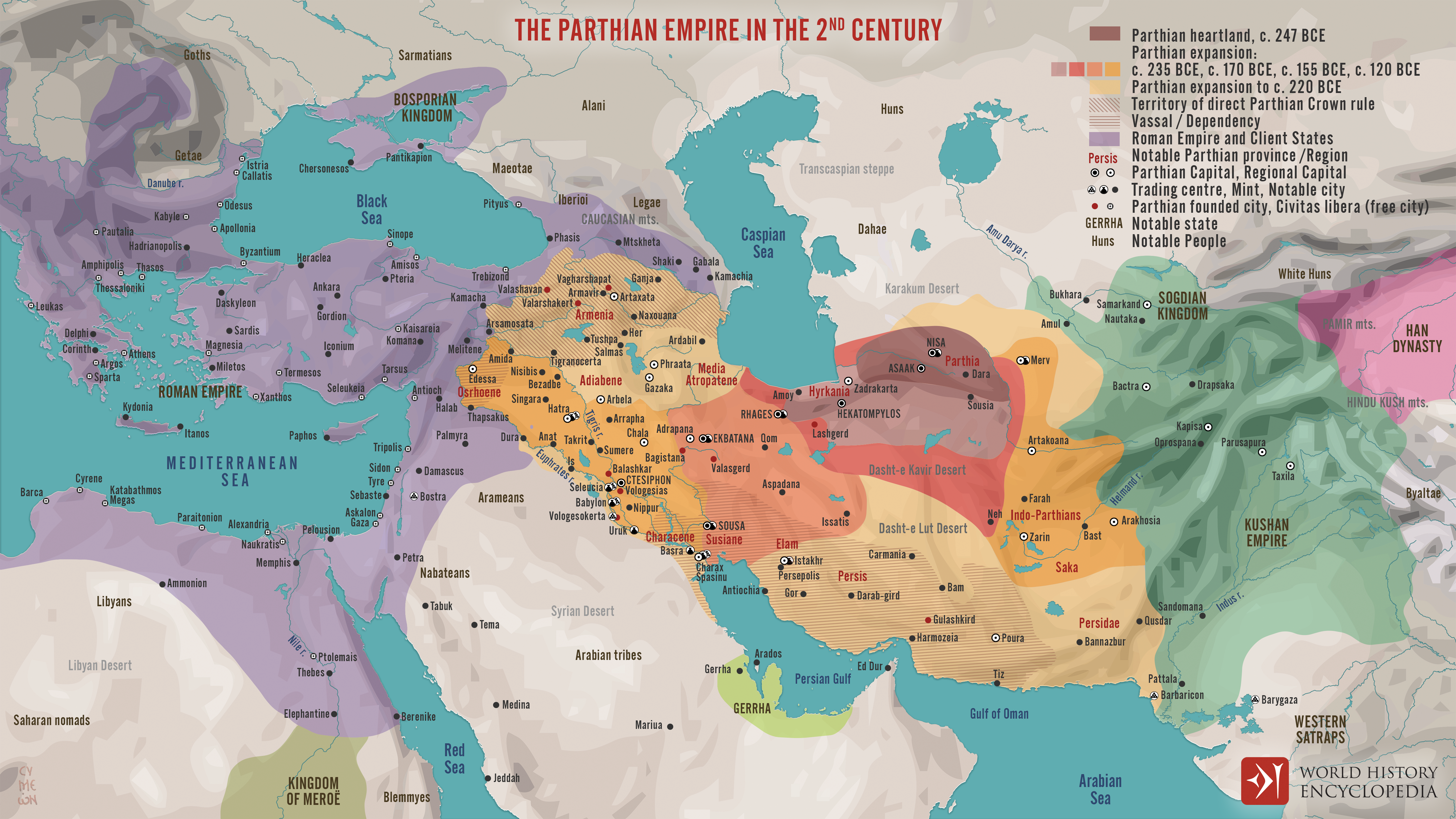
The Parthian, or Arsacid, [Empire](https://www.worldhistory.org/empire/) (c. 247 BCE–224 CE) was an Iranian imperial state that emerged as [Seleucid](https://www.worldhistory.org/Seleucid_Empire/) authority weakened in northeastern Iran. Arsaces I (reign c. 247–211 BCE), leader of the Parni, established the dynasty, but its transformation into a major empire occurred under Mithridates I (reign c. 165–132 BCE), who conquered [Media](https://www.worldhistory.org/disambiguation/media/) and [Babylonia](https://www.worldhistory.org/babylon/). The Arsacids combined Iranian traditions of kingship with institutions and urban cultures inherited from the [Hellenistic world](https://www.worldhistory.org/Hellenistic_Period/), governing through royal territories, powerful aristocratic houses, subordinate dynasties, and semi-autonomous [cities](https://www.worldhistory.org/city/).
[Parthia](https://www.worldhistory.org/disambiguation/Parthia/)’s historical significance arose from its position between the [Mediterranean](https://www.worldhistory.org/disambiguation/mediterranean/), the Iranian plateau, Central Asia, and northern [India](https://www.worldhistory.org/india/). It supported long-distance exchange while limiting [Roman](https://www.worldhistory.org/disambiguation/Roman/) expansion, most famously at the [Battle](https://www.worldhistory.org/disambiguation/battle/) of Carrhae (53 BCE). The Roman–Parthian frontier was not a fixed boundary: [Armenia](https://www.worldhistory.org/armenia/) and northern [Mesopotamia](https://www.worldhistory.org/Mesopotamia/) repeatedly shifted in alignment, demonstrating that dynastic legitimacy, client kingship, and military influence could matter as much as direct annexation. Succession disputes and the growing independence of regional rulers eventually weakened the Arsacid monarchy, allowing [Ardashir I](https://www.worldhistory.org/Ardashir_I/) (reign 224–240 CE) to defeat Artabanus IV/V in 224 CE and establish the [Sasanian Empire](https://www.worldhistory.org/Sasanian_Empire/).
#### Editorial Review
This human-authored image has been reviewed by our editorial team before publication to ensure accuracy, reliability and adherence to academic standards in accordance with our [editorial policy](https://www.worldhistory.org/static/editorial-policy/).
## About the Author
Simeon is a freelance visual designer and history educator, passionate about the human stories that shape the past.
- [Linkedin Profile](https://www.linkedin.com/in/simeon-netchev/)
## Cite This Work
### APA
Netchev, S. (2026, July 12). Map of the Parthian (Arsacid) Empire, c. 150 CE: Iran’s Cavalry Empire Between Rome and the Silk Roads. *World History Encyclopedia*.
### Chicago
Netchev, Simeon. "Map of the Parthian (Arsacid) Empire, c. 150 CE: Iran’s Cavalry Empire Between Rome and the Silk Roads." *World History Encyclopedia*, July 12, 2026. .
### MLA
Netchev, Simeon. "Map of the Parthian (Arsacid) Empire, c. 150 CE: Iran’s Cavalry Empire Between Rome and the Silk Roads." *World History Encyclopedia*, 12 Jul 2026, .
## License & Copyright
Submitted by [Simeon Netchev](https://www.worldhistory.org/user/simeonnetchev/ "User Page: Simeon Netchev"), published on 12 July 2026. The copyright holder has published this content under the following license: [Creative Commons Attribution-NonCommercial-NoDerivs](https://creativecommons.org/licenses/by-nc/4.0deed.en). This licence only allows others to download this content and share it with others as long as the author is credited, but they can't change the content in any way or use it commercially. When republishing on the web a hyperlink back to the original content source URL must be included. Please note that content linked from this page may have different licensing terms.