---
title: Map of Roman North Africa (146 BCE - 395 CE)
author: Simeon Netchev
source: https://www.worldhistory.org/image/16818/map-of-roman-north-africa-146-bce---395-ce/
format: machine-readable-alternate
license: Creative Commons Attribution-NonCommercial-NoDerivs (https://creativecommons.org/licenses/by-nc/4.0)
updated: 2025-06-11
---
# Map of Roman North Africa (146 BCE - 395 CE)
_Authored by [Simeon Netchev](https://www.worldhistory.org/user/simeonnetchev/)_
## Image File
[](https://www.worldhistory.org/uploads/images/16818.png)
## Image Caption
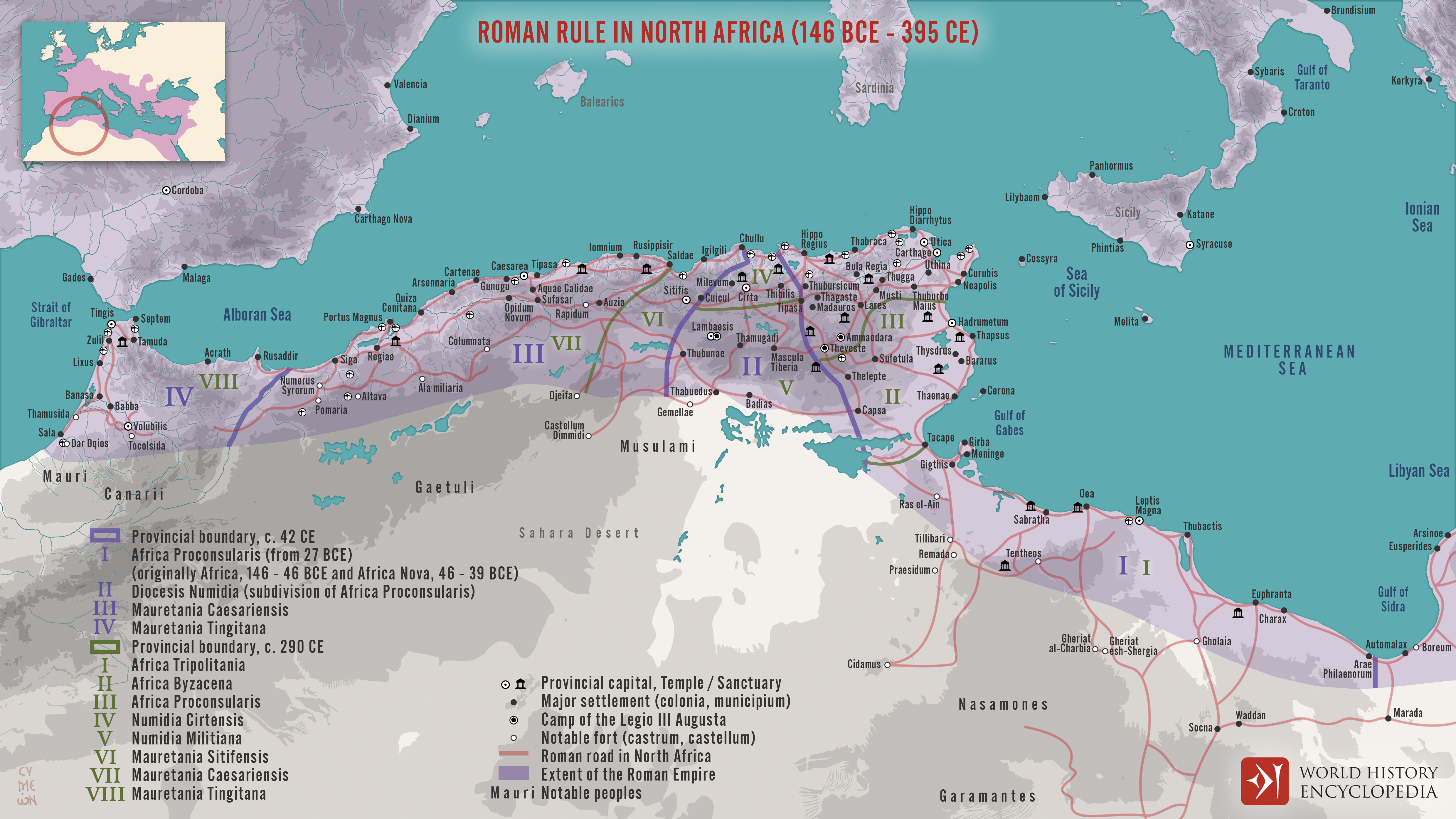
This map illustrates the scope and administrative organization of the [Roman](https://www.worldhistory.org/disambiguation/Roman/) provinces in North [Africa](https://www.worldhistory.org/disambiguation/africa/), from the initial [conquest](https://www.worldhistory.org/warfare/) in 146 BCE to their full integration into the [empire](https://www.worldhistory.org/empire/). Following the destruction of [Carthage](https://www.worldhistory.org/carthage/) at the end of the [Third Punic War](https://www.worldhistory.org/Third_Punic_War/), [Rome](https://www.worldhistory.org/Rome/) began establishing provinces across the Maghreb, shaping a region that would become central to the empire’s [economy](https://www.worldhistory.org/disambiguation/economy/) and stability.
From the formation of Africa Proconsularis (in what is now Tunisia and western Libya) to the later provinces of [Mauretania](https://www.worldhistory.org/Mauretania/) Caesariensis and Mauretania Tingitana (in modern Algeria and Morocco), Roman North Africa flourished between the 2nd century BCE and the 4th century CE. Rich in grain, olive oil, and [trade](https://www.worldhistory.org/disambiguation/trade/) wealth, these provinces were among the most productive in the empire. The map also reflects the layered provincial governance system—ranging from senatorial provinces to imperial territories—highlighting Rome’s sophisticated approach to managing distant yet economically vital lands.
#### Editorial Review
This human-authored image has been reviewed by our editorial team before publication to ensure accuracy, reliability and adherence to academic standards in accordance with our [editorial policy](https://www.worldhistory.org/static/editorial-policy/).
## About the Author
Simeon is a freelance visual designer and history educator, passionate about the human stories that shape the past.
- [Linkedin Profile](https://www.linkedin.com/in/simeon-netchev/)
## Cite This Work
### APA
Netchev, S. (2022, December 13). Map of Roman North Africa (146 BCE - 395 CE). *World History Encyclopedia*.
### Chicago
Netchev, Simeon. "Map of Roman North Africa (146 BCE - 395 CE)." *World History Encyclopedia*, December 13, 2022. .
### MLA
Netchev, Simeon. "Map of Roman North Africa (146 BCE - 395 CE)." *World History Encyclopedia*, 13 Dec 2022, .
## License & Copyright
Submitted by [Simeon Netchev](https://www.worldhistory.org/user/simeonnetchev/ "User Page: Simeon Netchev"), published on 13 December 2022. The copyright holder has published this content under the following license: [Creative Commons Attribution-NonCommercial-NoDerivs](https://creativecommons.org/licenses/by-nc/4.0deed.en). This licence only allows others to download this content and share it with others as long as the author is credited, but they can't change the content in any way or use it commercially. When republishing on the web a hyperlink back to the original content source URL must be included. Please note that content linked from this page may have different licensing terms.