---
title: Map of Roman North Africa - Provinces, Roads & Frontiers: Expansion, administration & economic foundations 146 BCE–395
author: Simeon Netchev
source: https://www.worldhistory.org/image/16818/map-of-roman-north-africa---provinces-roads--front/
format: machine-readable-alternate
license: Creative Commons Attribution-NonCommercial-NoDerivs (https://creativecommons.org/licenses/by-nc/4.0)
updated: 2026-06-02
---
# Map of Roman North Africa - Provinces, Roads & Frontiers: Expansion, administration & economic foundations 146 BCE–395
_Authored by [Simeon Netchev](https://www.worldhistory.org/user/simeonnetchev/)_
## Image File
[](https://www.worldhistory.org/uploads/images/16818.png)
## Image Caption
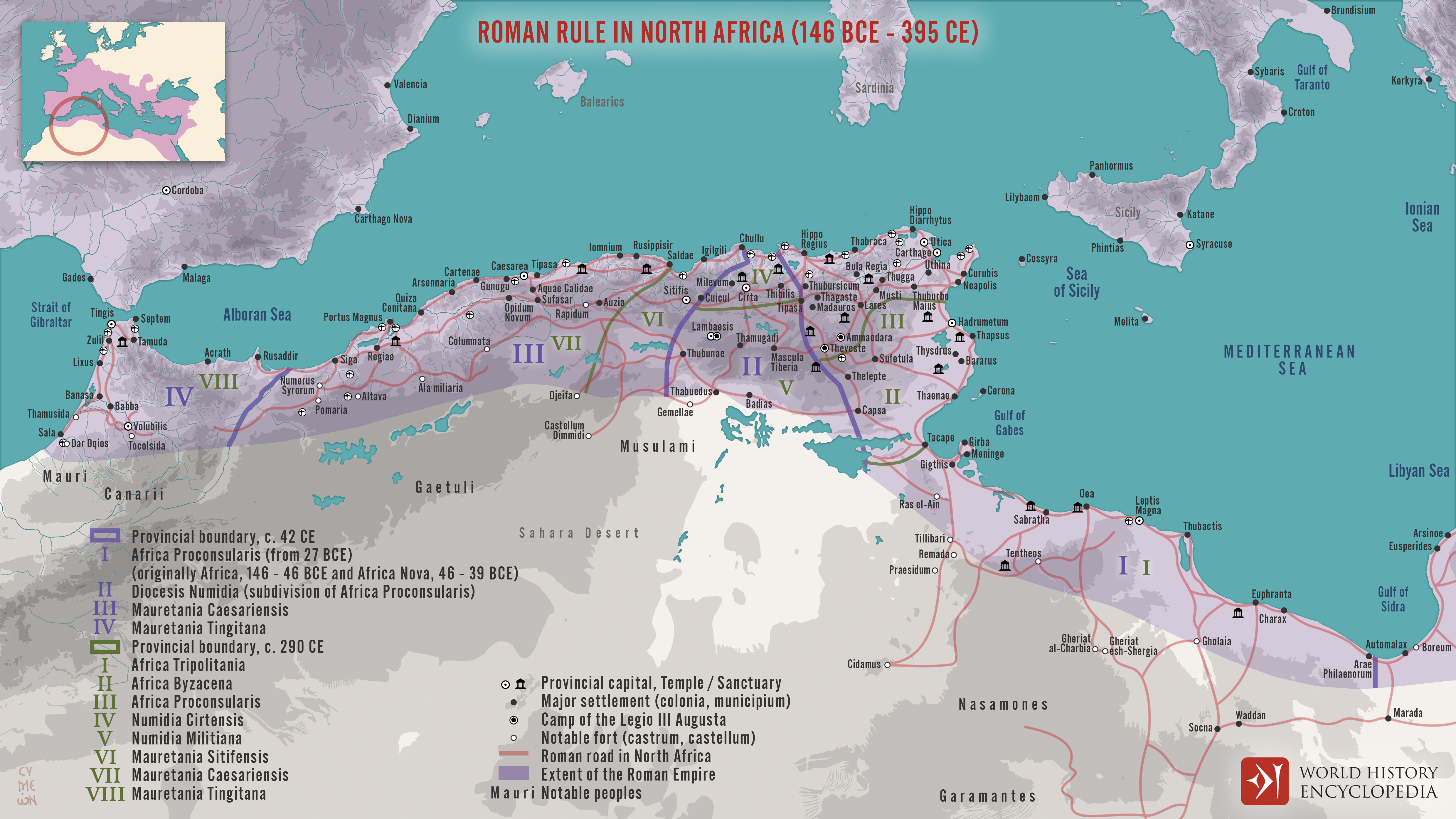
[Roman](https://www.worldhistory.org/disambiguation/Roman/) involvement in North [Africa](https://www.worldhistory.org/disambiguation/africa/) began with the destruction of [Carthage](https://www.worldhistory.org/carthage/) in the [Third Punic War](https://www.worldhistory.org/Third_Punic_War/) (149-146 BCE), after which [Rome](https://www.worldhistory.org/Rome/) established the province of Africa and gradually expanded its authority across the Maghreb. Over the following centuries, particularly under rulers such as [Augustus](https://www.worldhistory.org/augustus/) (reign 27 BCE-14 CE), [Claudius](https://www.worldhistory.org/claudius/) (reign 41-54 CE), and [Diocletian](https://www.worldhistory.org/Diocletian/) (reign 284-305 CE), North Africa was reorganized into a network of provinces stretching from Cyrenaica in modern Libya to [Mauretania](https://www.worldhistory.org/Mauretania/) Tingitana in present-day Morocco. This process transformed the region from a frontier of [conquest](https://www.worldhistory.org/warfare/) into one of the most stable and strategically important parts of the Roman world.
By the High [Empire](https://www.worldhistory.org/empire/) (1st-3rd centuries CE), North Africa had become a major center of agricultural production, [trade](https://www.worldhistory.org/disambiguation/trade/), and urban development. Provinces such as Africa Proconsularis, Numidia, and the Mauretanias supplied grain, olive oil, livestock, and tax revenues that helped sustain the wider empire. Roman authority was maintained through a combination of provincial administration, military frontiers, road networks, and alliances with local communities. The region's evolving administrative structure, from senatorial provinces to imperial territories and, later, Diocletian's smaller provincial units, illustrates Rome's ability to adapt its governance to the diverse economic, military, and cultural realities of one of its most prosperous provinces.
#### Editorial Review
This human-authored image has been reviewed by our editorial team before publication to ensure accuracy, reliability and adherence to academic standards in accordance with our [editorial policy](https://www.worldhistory.org/static/editorial-policy/).
## About the Author
Simeon is a freelance visual designer and history educator, passionate about the human stories that shape the past.
- [Linkedin Profile](https://www.linkedin.com/in/simeon-netchev/)
## Cite This Work
### APA
Netchev, S. (2026, June 02). Map of Roman North Africa - Provinces, Roads & Frontiers: Expansion, administration & economic foundations 146 BCE–395. *World History Encyclopedia*.
### Chicago
Netchev, Simeon. "Map of Roman North Africa - Provinces, Roads & Frontiers: Expansion, administration & economic foundations 146 BCE–395." *World History Encyclopedia*, June 02, 2026. .
### MLA
Netchev, Simeon. "Map of Roman North Africa - Provinces, Roads & Frontiers: Expansion, administration & economic foundations 146 BCE–395." *World History Encyclopedia*, 02 Jun 2026, .
## License & Copyright
Submitted by [Simeon Netchev](https://www.worldhistory.org/user/simeonnetchev/ "User Page: Simeon Netchev"), published on 02 June 2026. The copyright holder has published this content under the following license: [Creative Commons Attribution-NonCommercial-NoDerivs](https://creativecommons.org/licenses/by-nc/4.0deed.en). This licence only allows others to download this content and share it with others as long as the author is credited, but they can't change the content in any way or use it commercially. When republishing on the web a hyperlink back to the original content source URL must be included. Please note that content linked from this page may have different licensing terms.