---
title: Map of the British Raj c. 1930
author: Simeon Netchev
source: https://www.worldhistory.org/image/16537/map-of-the-british-raj-c-1930/
format: machine-readable-alternate
license: Creative Commons Attribution-NonCommercial-NoDerivs (https://creativecommons.org/licenses/by-nc/4.0)
updated: 2025-05-16
---
# Map of the British Raj c. 1930
_Authored by [Simeon Netchev](https://www.worldhistory.org/user/simeonnetchev/)_
## Image File
[](https://www.worldhistory.org/uploads/images/16537.png)
## Image Caption
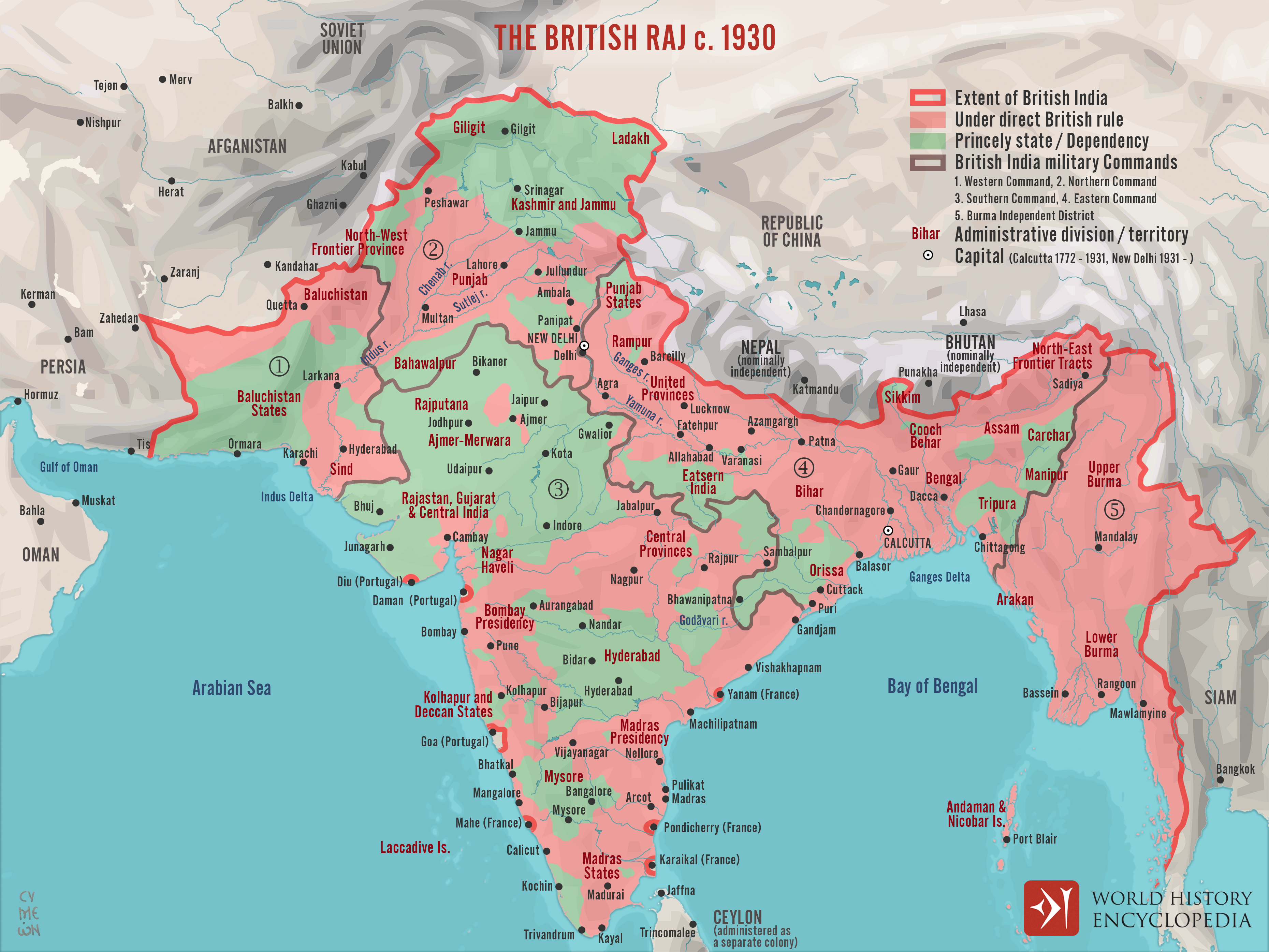
A map illustrating the British Raj around 1930, a period of direct British rule over the Indian subcontinent that began in 1858. Following the [Sepoy Mutiny](https://www.worldhistory.org/Sepoy_Mutiny/) of 1857, also known as the First [War](https://www.worldhistory.org/disambiguation/War/) of Independence, the British Parliament passed the *Act for the Better Government of [India](https://www.worldhistory.org/india/)*. This legislation transferred power from the [East India Company](https://www.worldhistory.org/East_India_Company/) to the British Crown. The last Mughal Emperor, Bahadur Shah II, was exiled to Burma, and [Queen Victoria](https://www.worldhistory.org/Queen_Victoria/) (reign 1837–1901) was declared Empress of India, marking the formal start of the Raj.
While [Britain](https://www.worldhistory.org/disambiguation/Britain/) exercised direct control over vast regions of South Asia, approximately two-fifths of the subcontinent remained divided among nearly 800 princely states. These were native-led territories with varying degrees of autonomy, governed under British supervision through subsidiary alliances. The British Raj persisted until 1947, when decolonization and nationalist movements culminated in the partition of British India into two independent dominions: India and Pakistan.
#### Editorial Review
This human-authored image has been reviewed by our editorial team before publication to ensure accuracy, reliability and adherence to academic standards in accordance with our [editorial policy](https://www.worldhistory.org/static/editorial-policy/).
## About the Author
Simeon is a freelance visual designer and history educator, passionate about the human stories that shape the past.
- [Linkedin Profile](https://www.linkedin.com/in/simeon-netchev/)
## Cite This Work
### APA
Netchev, S. (2022, October 13). Map of the British Raj c. 1930. *World History Encyclopedia*.
### Chicago
Netchev, Simeon. "Map of the British Raj c. 1930." *World History Encyclopedia*, October 13, 2022. .
### MLA
Netchev, Simeon. "Map of the British Raj c. 1930." *World History Encyclopedia*, 13 Oct 2022, .
## License & Copyright
Submitted by [Simeon Netchev](https://www.worldhistory.org/user/simeonnetchev/ "User Page: Simeon Netchev"), published on 13 October 2022. The copyright holder has published this content under the following license: [Creative Commons Attribution-NonCommercial-NoDerivs](https://creativecommons.org/licenses/by-nc/4.0deed.en). This licence only allows others to download this content and share it with others as long as the author is credited, but they can't change the content in any way or use it commercially. When republishing on the web a hyperlink back to the original content source URL must be included. Please note that content linked from this page may have different licensing terms.