---
title: Map of the Mughal Empire at Its Greatest Extent, c. 1707: Expansion, provinces, and contested frontiers
author: Simeon Netchev
source: https://www.worldhistory.org/image/16429/map-of-the-mughal-empire-at-its-greatest-extent-c/
format: machine-readable-alternate
license: Creative Commons Attribution-NonCommercial-NoDerivs (https://creativecommons.org/licenses/by-nc/4.0)
updated: 2026-08-03
---
# Map of the Mughal Empire at Its Greatest Extent, c. 1707: Expansion, provinces, and contested frontiers
_Authored by [Simeon Netchev](https://www.worldhistory.org/user/simeonnetchev/)_
## Image File
[](https://www.worldhistory.org/uploads/images/16429.png)
## Image Caption
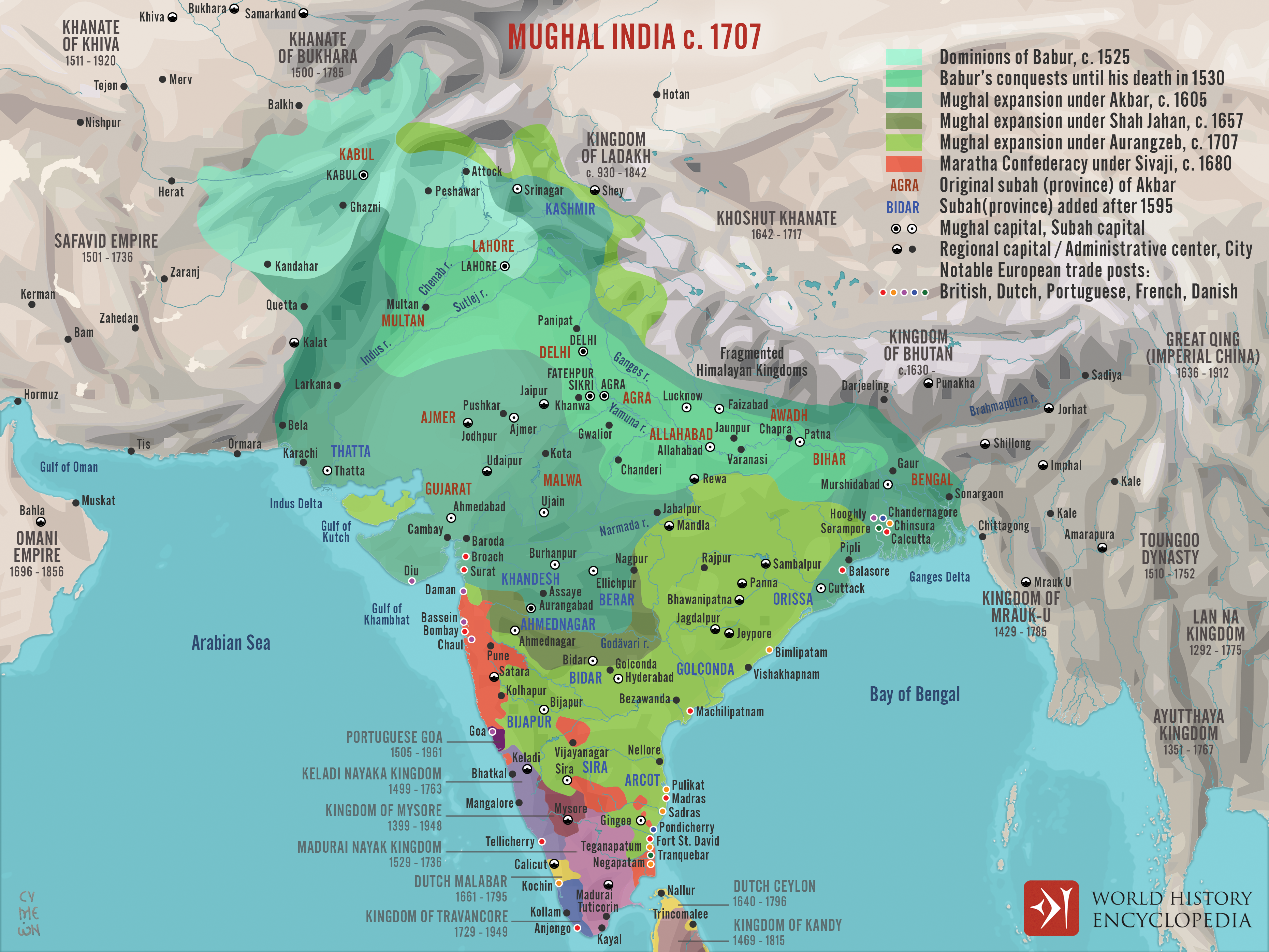
The Mughal [Empire](https://www.worldhistory.org/empire/) (1526–1857) emerged from the military and political ambitions of Ẓahīr al-Dīn Muḥammad Babur (reign 1526–1530), a Timurid prince from Central Asia who ruled Kabul before invading northern [India](https://www.worldhistory.org/india/). His victory over Ibrahim Lodi at the First [Battle](https://www.worldhistory.org/disambiguation/battle/) of Panipat (1526) established a new dynasty, but stable imperial government developed gradually. Under Akbar (reign 1556–1605), territorial expansion was combined with a more systematic provincial administration, revenue collection, military organization, and alliances with powerful regional elites, particularly Rajput rulers. These institutions allowed the dynasty to govern a culturally, religiously, and politically diverse population while integrating older Indian administrative traditions into a Persianate imperial framework.
Mughal power reached its greatest geographical extent under Aurangzeb (reign 1658–1707), following the annexation of the Deccan sultanates of Bijapur (1686) and Golconda (1687) and prolonged [warfare](https://www.worldhistory.org/warfare/) against Maratha forces and other regional opponents. By the beginning of the eighteenth century, the empire encompassed most of the Indian subcontinent and governed an estimated 100–150 million people. Its strength rested on extensive agrarian revenues, a large military establishment, productive [cities](https://www.worldhistory.org/city/), and participation in expanding Indian Ocean [trade](https://www.worldhistory.org/disambiguation/trade/). However, expansion did not produce uniform control: imperial authority ranged from direct provincial administration to tributary relationships and contested frontier influence. The costs of continuous warfare, succession disputes, regional resistance, and the growing autonomy of provincial elites became increasingly significant after Aurangzeb’s [death](https://www.worldhistory.org/disambiguation/Death/) in 1707, contributing to political fragmentation of the Mughal state.
#### Editorial Review
This human-authored image has been reviewed by our editorial team before publication to ensure accuracy, reliability and adherence to academic standards in accordance with our [editorial policy](https://www.worldhistory.org/static/editorial-policy/).
## About the Author
Simeon is a freelance visual designer and history educator, passionate about the human stories that shape the past.
- [Linkedin Profile](https://www.linkedin.com/in/simeon-netchev/)
## Cite This Work
### APA
Netchev, S. (2026, August 03). Map of the Mughal Empire at Its Greatest Extent, c. 1707: Expansion, provinces, and contested frontiers. *World History Encyclopedia*.
### Chicago
Netchev, Simeon. "Map of the Mughal Empire at Its Greatest Extent, c. 1707: Expansion, provinces, and contested frontiers." *World History Encyclopedia*, August 03, 2026. .
### MLA
Netchev, Simeon. "Map of the Mughal Empire at Its Greatest Extent, c. 1707: Expansion, provinces, and contested frontiers." *World History Encyclopedia*, 03 Aug 2026, .
## License & Copyright
Submitted by [Simeon Netchev](https://www.worldhistory.org/user/simeonnetchev/ "User Page: Simeon Netchev"), published on 03 August 2026. The copyright holder has published this content under the following license: [Creative Commons Attribution-NonCommercial-NoDerivs](https://creativecommons.org/licenses/by-nc/4.0deed.en). This licence only allows others to download this content and share it with others as long as the author is credited, but they can't change the content in any way or use it commercially. When republishing on the web a hyperlink back to the original content source URL must be included. Please note that content linked from this page may have different licensing terms.