---
title: Map of the Hadrian’s wall (Vallum Hadriani) c. 122 CE
author: Simeon Netchev
source: https://www.worldhistory.org/image/16294/map-of-the-hadrians-wall-vallum-hadriani-c-122-ce/
format: machine-readable-alternate
license: Creative Commons Attribution-NonCommercial-NoDerivs (https://creativecommons.org/licenses/by-nc/4.0)
updated: 2026-01-11
---
# Map of the Hadrian’s wall (Vallum Hadriani) c. 122 CE
_Authored by [Simeon Netchev](https://www.worldhistory.org/user/simeonnetchev/)_
## Image File
[](https://www.worldhistory.org/uploads/images/16294.png)
## Image Caption
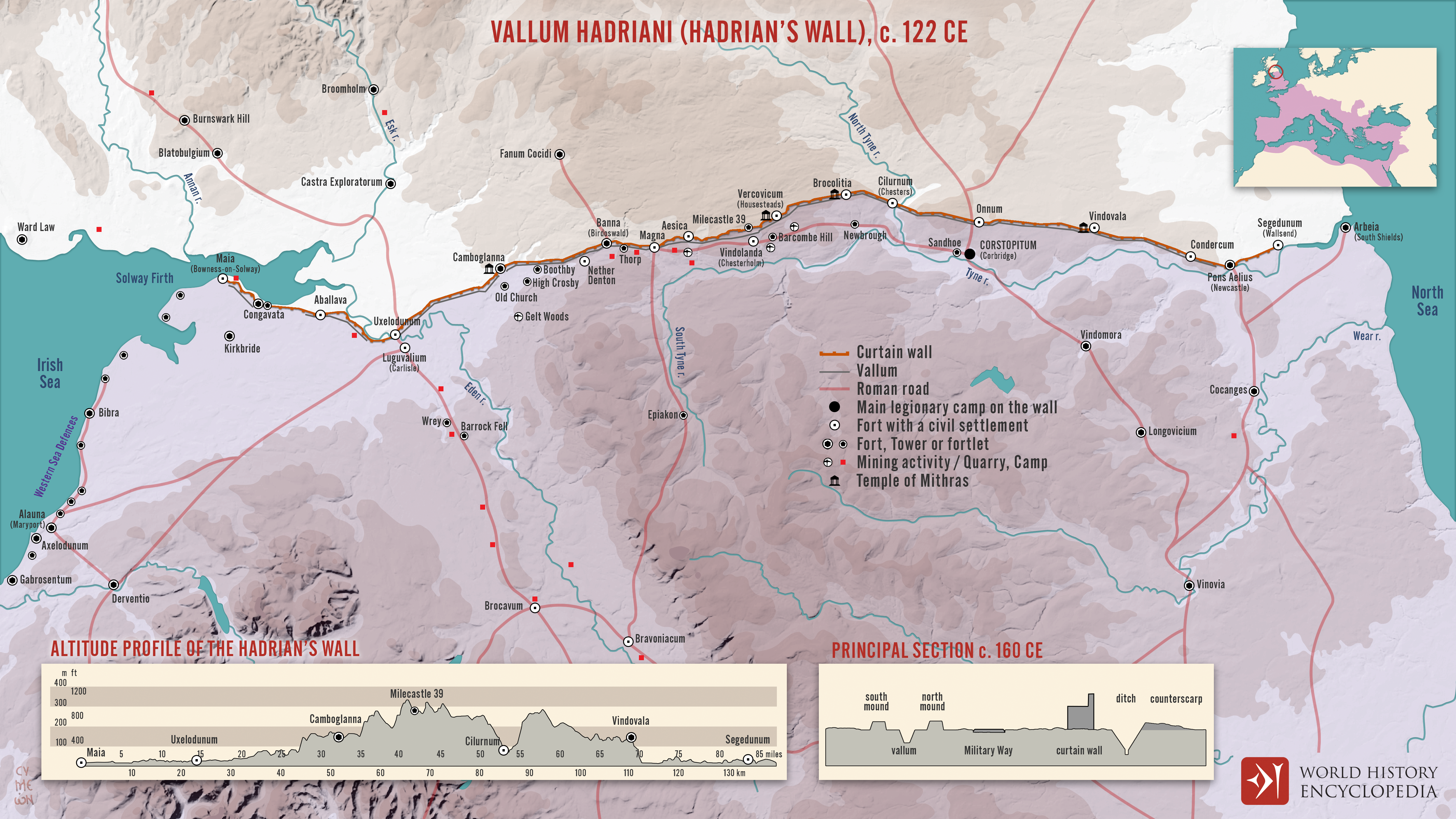
[Hadrian](https://www.worldhistory.org/hadrian/)’s [Wall](https://www.worldhistory.org/wall/) was constructed from c. 122 CE onward during the reign of Emperor Hadrian (reign 117–138 CE) as part of a broader imperial strategy to consolidate, rather than endlessly expand, [Roman](https://www.worldhistory.org/disambiguation/Roman/) power. Running 73 miles (118 km) across northern [Britain](https://www.worldhistory.org/disambiguation/Britain/) from the Tyne to the Solway Firth, the wall marked the formal northern frontier of Roman authority. It did not simply divide Romans from northern peoples, such as later groups identified as [Picts](https://www.worldhistory.org/picts/), but defined a controlled zone where movement, taxation, and military response could be regulated.
Built and maintained by soldiers from the three Roman legions stationed in Britain, Hadrian’s Wall functioned as a complex frontier system rather than a single barrier. Forts, milecastles, watchtowers, roads, and civilian settlements created a militarized landscape that facilitated surveillance, communication, and supply. Although the frontier briefly shifted north to the [Antonine Wall](https://www.worldhistory.org/Antonine_Wall/) (c. 142–162 CE) under [Antoninus Pius](https://www.worldhistory.org/Antoninus_Pius/) (reign 138–161 CE), Hadrian’s Wall remained the [empire](https://www.worldhistory.org/empire/)’s principal northern boundary for much of the 2nd to 4th centuries CE. As both an instrument of control and a statement of imperial presence, the wall embodied [Rome](https://www.worldhistory.org/Rome/)’s approach to managing diversity, security, and power at the edges of empire.
#### Editorial Review
This human-authored image has been reviewed by our editorial team before publication to ensure accuracy, reliability and adherence to academic standards in accordance with our [editorial policy](https://www.worldhistory.org/static/editorial-policy/).
## About the Author
Simeon is a freelance visual designer and history educator, passionate about the human stories that shape the past.
- [Linkedin Profile](https://www.linkedin.com/in/simeon-netchev/)
## Cite This Work
### APA
Netchev, S. (2026, January 11). Map of the Hadrian’s wall (Vallum Hadriani) c. 122 CE. *World History Encyclopedia*.
### Chicago
Netchev, Simeon. "Map of the Hadrian’s wall (Vallum Hadriani) c. 122 CE." *World History Encyclopedia*, January 11, 2026. .
### MLA
Netchev, Simeon. "Map of the Hadrian’s wall (Vallum Hadriani) c. 122 CE." *World History Encyclopedia*, 11 Jan 2026, .
## License & Copyright
Submitted by [Simeon Netchev](https://www.worldhistory.org/user/simeonnetchev/ "User Page: Simeon Netchev"), published on 11 January 2026. The copyright holder has published this content under the following license: [Creative Commons Attribution-NonCommercial-NoDerivs](https://creativecommons.org/licenses/by-nc/4.0deed.en). This licence only allows others to download this content and share it with others as long as the author is credited, but they can't change the content in any way or use it commercially. When republishing on the web a hyperlink back to the original content source URL must be included. Please note that content linked from this page may have different licensing terms.