---
title: Map of the Achaemenid Persian Empire c. 500 BCE
author: Simeon Netchev
source: https://www.worldhistory.org/image/16107/map-of-the-achaemenid-persian-empire-c-500-bce/
format: machine-readable-alternate
license: Creative Commons Attribution-NonCommercial-NoDerivs (https://creativecommons.org/licenses/by-nc/4.0)
updated: 2025-11-26
---
# Map of the Achaemenid Persian Empire c. 500 BCE
_Authored by [Simeon Netchev](https://www.worldhistory.org/user/simeonnetchev/)_
## Image File
[](https://www.worldhistory.org/uploads/images/16107.png)
## Image Caption
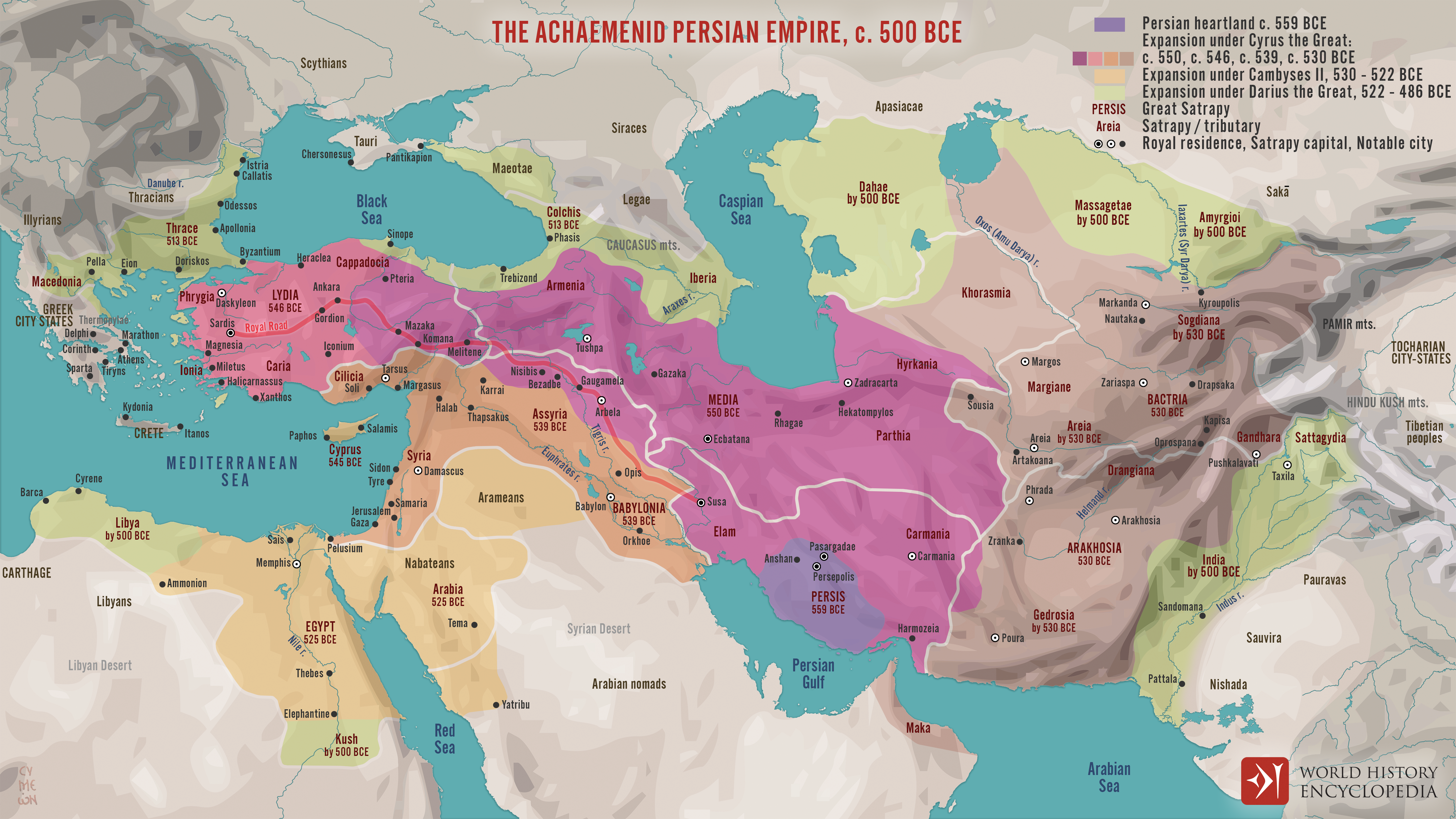
The [Achaemenid](https://www.worldhistory.org/disambiguation/Achaemenid/) [Persian Empire](https://www.worldhistory.org/disambiguation/Persian_Empire/) emerged in the mid-6th century BCE when [Cyrus II](https://www.worldhistory.org/Cyrus_the_Great/) (reign 559–530 BCE) united the Persian tribes and overthrew the Median kingdom (c. 550 BCE), establishing a new imperial state that would reshape the political landscape of the Ancient [Near East](https://www.worldhistory.org/Near_East/). Under [Cyrus](https://www.worldhistory.org/disambiguation/Cyrus/) and his successors, the [empire](https://www.worldhistory.org/empire/) expanded rapidly across [Anatolia](https://www.worldhistory.org/Asia_Minor/), [Mesopotamia](https://www.worldhistory.org/Mesopotamia/), and the eastern Iranian plateau. By the early 5th century BCE, during the reign of [Darius I](https://www.worldhistory.org/Darius_I/) (reign 522–486 BCE), the Achaemenid realm reached its greatest extent, integrating the three great early centers of [civilization](https://www.worldhistory.org/civilization/): Mesopotamia, the [Nile](https://www.worldhistory.org/nile/) Valley, and the Indus River valley. This unified territory became a vast administrative and cultural network linking peoples, religions, and economies across more than 5,000 km.
For nearly two centuries, the [Achaemenid Empire](https://www.worldhistory.org/Achaemenid_Empire/) functioned as a sophisticated imperial system characterized by satrapal governance, standardized taxation, an extensive road network, monumental [architecture](https://www.worldhistory.org/disambiguation/architecture/), and a policy of cultural accommodation that allowed diverse communities to maintain local traditions. Its [cities](https://www.worldhistory.org/city/), [Persepolis](https://www.worldhistory.org/persepolis/), [Susa](https://www.worldhistory.org/susa/), [Babylon](https://www.worldhistory.org/babylon/), [Memphis](https://www.worldhistory.org/Memphis_(Ancient_Egypt)/), served as hubs of diplomacy, scholarship, and artistic production, illustrating the empire’s role as a center of innovation in [science](https://www.worldhistory.org/science/), engineering, [religion](https://www.worldhistory.org/religion/), and statecraft. The empire’s decline began in the 4th century BCE amid internal revolts and external pressures, culminating in its [conquest](https://www.worldhistory.org/warfare/) by [Alexander](https://www.worldhistory.org/disambiguation/Alexander/) III, the Great, of [Macedon](https://www.worldhistory.org/macedon/) (reign 336–323 BCE) in 329 BCE. Yet its administrative models, artistic traditions, and political ideals profoundly influenced later empires across the [Mediterranean](https://www.worldhistory.org/disambiguation/mediterranean/) and the Near East.
#### Editorial Review
This human-authored image has been reviewed by our editorial team before publication to ensure accuracy, reliability and adherence to academic standards in accordance with our [editorial policy](https://www.worldhistory.org/static/editorial-policy/).
## About the Author
Simeon is a freelance visual designer and history educator, passionate about the human stories that shape the past.
- [Linkedin Profile](https://www.linkedin.com/in/simeon-netchev/)
## Cite This Work
### APA
Netchev, S. (2025, November 26). Map of the Achaemenid Persian Empire c. 500 BCE. *World History Encyclopedia*.
### Chicago
Netchev, Simeon. "Map of the Achaemenid Persian Empire c. 500 BCE." *World History Encyclopedia*, November 26, 2025. .
### MLA
Netchev, Simeon. "Map of the Achaemenid Persian Empire c. 500 BCE." *World History Encyclopedia*, 26 Nov 2025, .
## License & Copyright
Submitted by [Simeon Netchev](https://www.worldhistory.org/user/simeonnetchev/ "User Page: Simeon Netchev"), published on 26 November 2025. The copyright holder has published this content under the following license: [Creative Commons Attribution-NonCommercial-NoDerivs](https://creativecommons.org/licenses/by-nc/4.0deed.en). This licence only allows others to download this content and share it with others as long as the author is credited, but they can't change the content in any way or use it commercially. When republishing on the web a hyperlink back to the original content source URL must be included. Please note that content linked from this page may have different licensing terms.